Work in Progress
Bikepacking to the Colorado 14ers is currently being written and published publicly. Get news and updates by joining the Facebook group, Instagram, Twitter, subreddit, and mailing list.
Introduction
Segment #1 and Pikes Peak should now have given you a taste for things to come. We’ll delve deeper into the Front Range, where towns are replaced with saloon stops and Wilderness areas surrounding you will be the norm.
Both the MTB and All Road routes for Segment #2 will follow similar paths, as the Lost Creek Wilderness to the North and East of our starting point won’t be accessible by bike. Both versions will be taking advantage of the Tarryall Road Colorado Trail bike detour route around the Lost Creek Wilderness, so expect some friendly company along the way.
Hopefully the allure of singletrack all the way to Summit County starting at Kenosha Pass won’t persuade you to change your trip’s itinerary before you get to the next trailhead! But if it does, I’ll be describing a side trip for you.
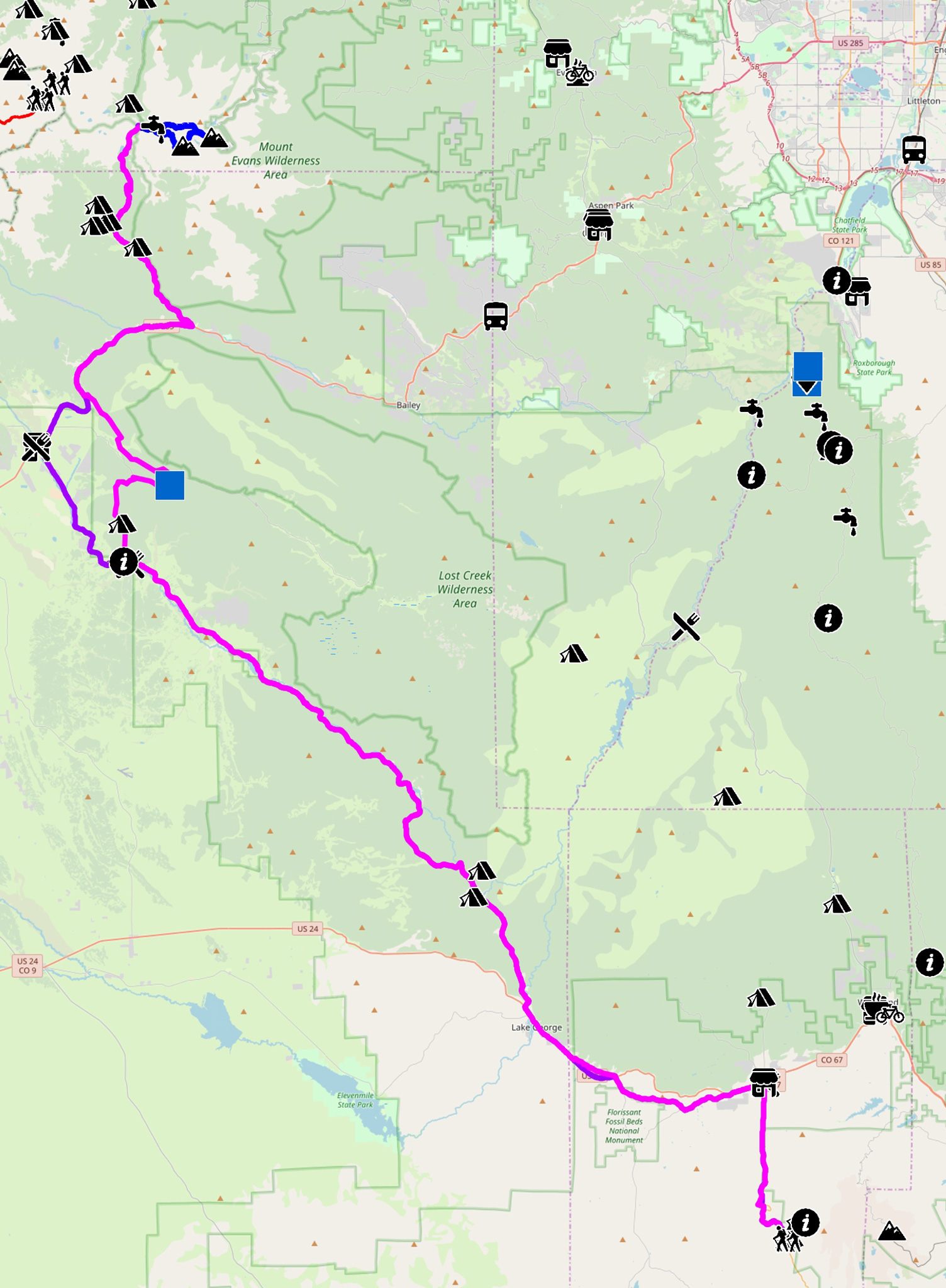
We’ll end our route somewhere near the crest of Guanella Pass, to take on a hike of Mt. Bierstadt, and optionally a traverse over to Mt. Evans via the Sawtooth Ridge (Class 3).
The MTB Narrative will take 2-4 days; the Road Narrative 2-3. Again, take a full day for the hiking portion and leave for your hike as early in the morning as possible.
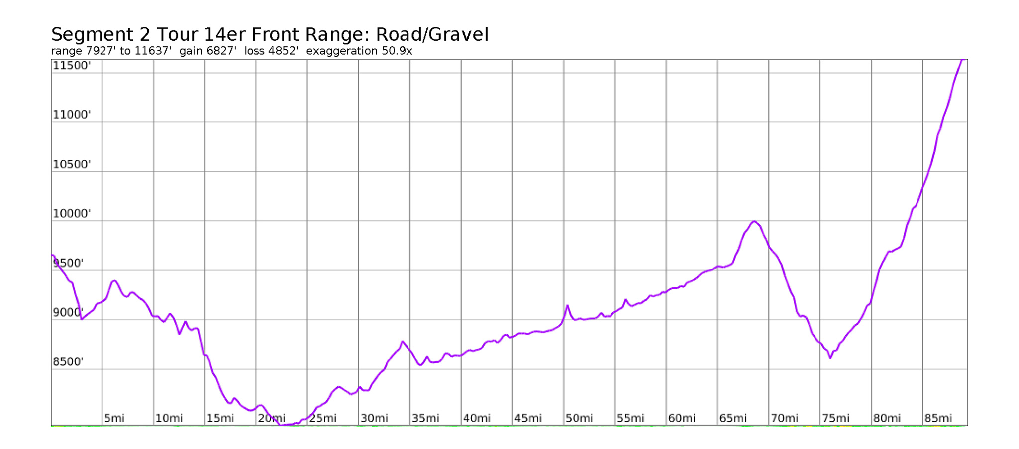
MTB Narrative

- Mileage: 91 miles
- Elevation Gain/Loss: +8048’/-6101′
Segment #2 starts at Horsethief Park TH and HW 67. Ride north on HW 67 towards the small town of Divide. A Grocery Store and Irish Pub/Pizza Joint are available right off the highway (see Segment 1 Narrative). If you’re looking for camping for the night, continue north up CR 5 and find a dispersed campsite after the National Forest boundary.
Resupply at Divide – the small towns that dot the highway leading up to Tarryall Road may be able to work as a resupply, but the grocery store in Divide is your last great chance until Georgetown, many miles away, and on the other side of Guanella Pass.
Ride west on HW 24 until reaching Lower Twin Rocks Road/CR 42 and turn left to cut off a little highway riding. Take CR 42 southwest, until you reach CR 421, and take a right on this road to head west. CR 421 ends at CR 1. Turn right onto CR1 and take it back to HW 24.
Enter the small town of Florissant.
Florissant Services
- Coffee: Costello Street Coffee House
2679 US-24
costellostreetcoffeehouse.com - Restaurant/Beer: Iron Tree Restaurant & Brewery
37 Costello Ave
irontreerestaurant.com
Take Costilla Road/West Florissant Street out of town north to cut down a little highway riding. Turn left on Teller County Road 31 and head west. This street will turn abruptly left and leave you back onto HW 24. Turn right on HW 24 and continue NW towards Lake George.
Lake George Services
- Groceries: Starky’s General Store
338316 US HW 24 - Coffee: Bla Bla Blah Caffe
38283 US HW 24
Once through Lake George, Continue NW on HW 24 until Tarryall Road and turn right to leave the traffic of HW 24 behind for the last time.
Tarryall Road should be relatively quiet in comparison to the highway. Most traffic will be local or from those looking to go fishing along the road. To the east of you is the Lost Creek Wilderness, which this road essentially makes the western border of. Dispersed camping opportunities will present themselves after a few miles riding on the road.
Of note is Matukat RD/CR 211, which you’ll find on the right hand side. This road is used as the bikepacking detour of the Colorado Trail around the Lost Creek Wilderness (Tarryall is the other road used). Dispersed camping off of the gravel Matukat RD/CR 211 may be more pleasant than further on Tarryall.
Golden to Pikes Peak to Golden Loop
If you want to loop your trip from Golden to Pikes Peak and then back to Golden, take Matukat RD/CR 211 NE to Stoney Pass Road/CR 560 N all the way to the Colorado Trail, then take the Colorado Trail east to the start way back in Waterton Canyon. You may need to resupply in Bailey before getting on the CT Proper – just keep on the same road N to Bailey, located on HW 285, then double-back to the CT. Don’t ride on HW 285, unless you need to bail – it’s not very pleasant. A bus stop for the Bustang is located up 285 NE at Pine Junction, which can take you to Denver to the east or Alma/Buena Vista/Salida to the west.
Services on Tarryall are going to be slim. A small general store may be open, and there is an absolutely required stop at Stage Stop Store and Saloon.
Tarryall Road Services
- Restaurant/Bar: Stage Stop Store and Saloon
53 Stagestop Rd
Jefferson, Colorado
stagestopsaloon.com
If you’re not in a great rush, this would make a fantastic point to stop for dinner, then spirit away for the night in the nearby National Forest. The Stage Stop is usually open until 1:00 am. Hopefully patrons do not turn into vampires at midnight.
Once past the trappings of civilization, continue on Tarryall Road to Rock Creek Hills Road/CR 39 and take a right. This is where the MTB and Road route narratives finally split. The Road narrative continues on Tarryall Road to the town center of Jefferson where a few additional services are available, then takes HW 285 on a good shoulder up to Kenosha Pass. The MTB narrative will take a rough gravel road to the Colorado Trail.
Both Narratives will meet up again at Kenosha Pass.
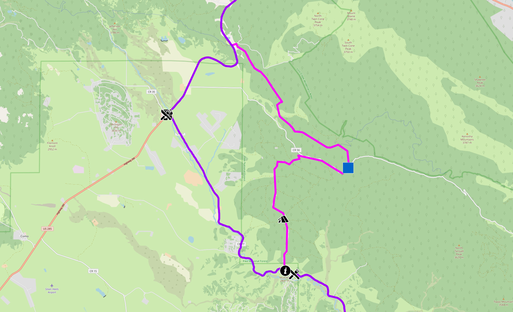
Rock Creek Hills Road/CR 39 starts out as rough gravel and we’ll be using it to access onto the Colorado Trail (singletrack). Free dispersed camping is available after the National Forest Boundary. Several offshoot 4WD tracks come off of CR 39, but stay on the main road, until it ends at Lost Park Road/CR 56. Take a right on CR 56 east, and take it until Rock Creek Road/FR 133. Take a left on FR 133 and travel north, until you cross the Colorado Trail. Take a left onto the Colorado Trail and head west.
Ride the Colorado Trail as it flows generally northwest to HW 285 and Kenosha Pass. A USFS campsite is located on the west side of the pass, and dispersed camping can be found further down the trail itself.
Side Trip: CT to Summit County, GDMBR to Como, 285 to Kenosha Pass
- Mileage: 68 miles
- Elevation Gain/Loss: +7791’/-7791′
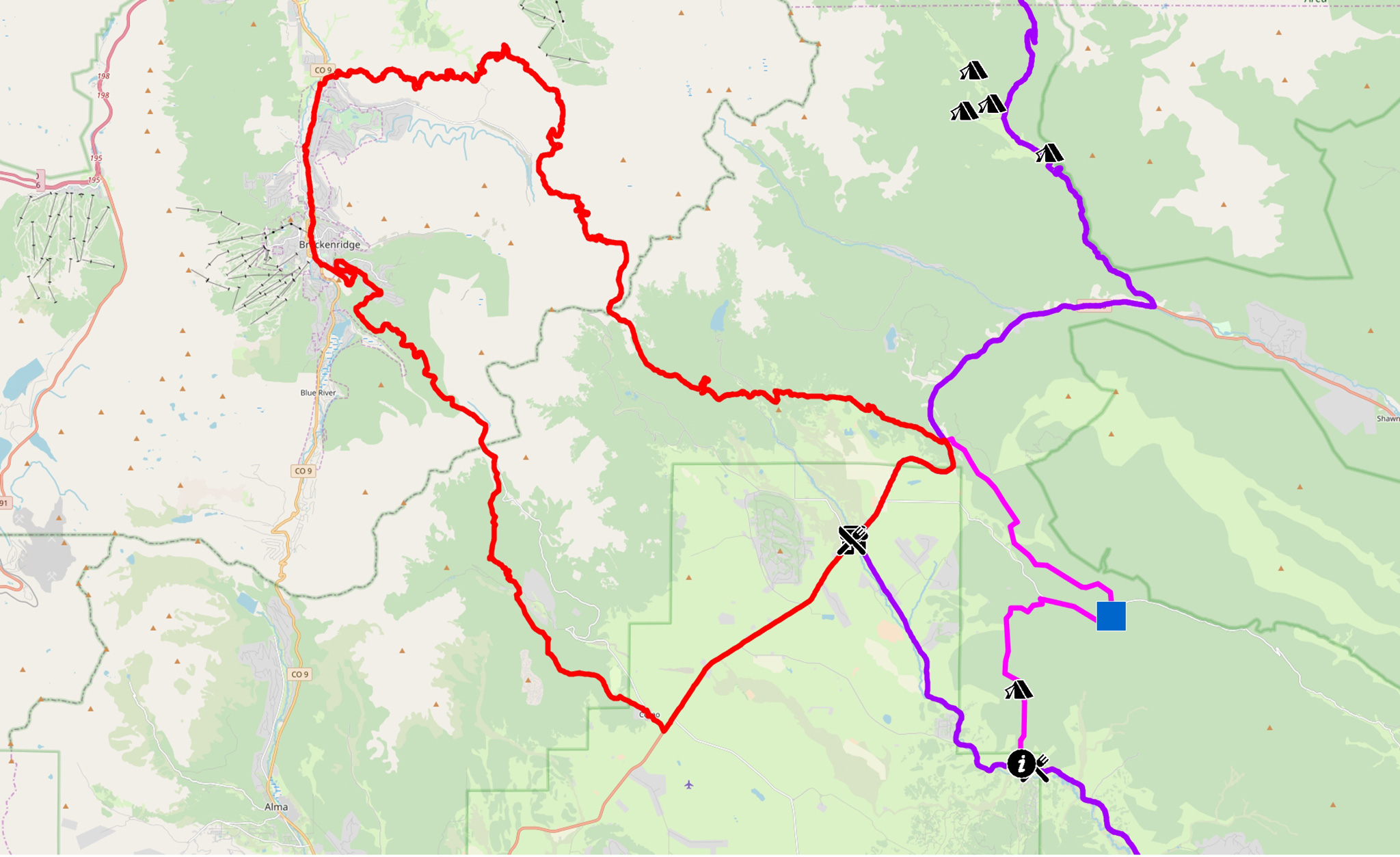
If you’re on the route primarily for the riding, continue on the Colorado Trail west from Kenosha Pass until you hit HW 9 near Breckenridge. The CT and the GDMBR converge here. The GDMBR follows the bike path system south to Breckenridge proper, then takes off up Boreas Pass. Follow the GDMBR up and over Boreas Pass (paved, then gravel) to the small town of Como (most likely, no services). Take HW 285 back up Kenosha Pass. If you’d like to throw in a hike along the way, the Centennial Mt. Silverheels can be accessed from the GMBR via its East Ridge route.
From Kenosha Pass, turn right on HW 285 and head north, then east. Unfortunately for us, HW 285 is getting busier each year, as people are utilizing it as an alternative to the gridlock of I-70 for mountain activities. But from Kenosha Pass, it’s mostly a well-shouldered, paved, 1,000′ descent to the town of Grant. Don’t expect too many services in Grant – perhaps a BBQ joint will be open, and a small trading post.
HW 285 seems like it would be a great paved bike route through the Front Range of Colorado, but it’s too busy for me to really suggest. Even the official CT detour goes the long way around Lost Creek Wilderness to the south, rather than taking the much shorter path via HW 285 from the North.
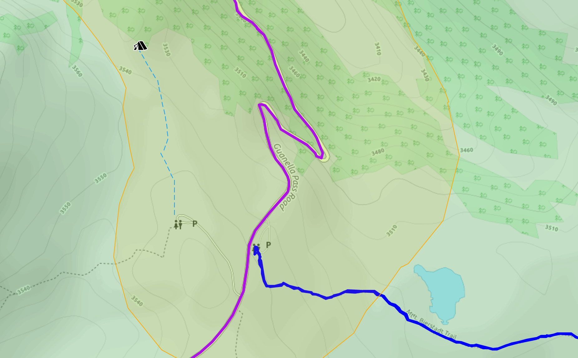
At Grant, turn left on Guanella Pass Road N. The crest of Guanella Pass Road is our final destination on this segment, and will give us access to Mt. Bierstadt and Mt. Evans.
Camping on Guanella Pass Road
Recent changes to the management of the Guanella Pass Scenic and Historic Byway Corridor have officially disallowed dispersed camping off of the corridor itself in most areas for most uses. Many of the often-used dispersed camping areas have simply become overused. [1]
North of Guanella Pass, you’ll need to be 1/4 mile off the centerline of the road itself before you can dispersed camp. There are exceptions. If you are to be utilizing the Mount Bierstadt Trail OR passing through, like you would be following this guidebook, you may dispersed camp. [2] I’ve highlighted a usable campsite that also almost fulfills the first exception. It’s suggested to camp outside the line of sight of the road, and save the USFS PDF linked in Footnote #2 just in case you need to explain yourself.
The east side of Guanella Pass is mostly Wilderness, so isn’t appropriate for dispersed camping with a bicycle.
Free, Dispersed Camping
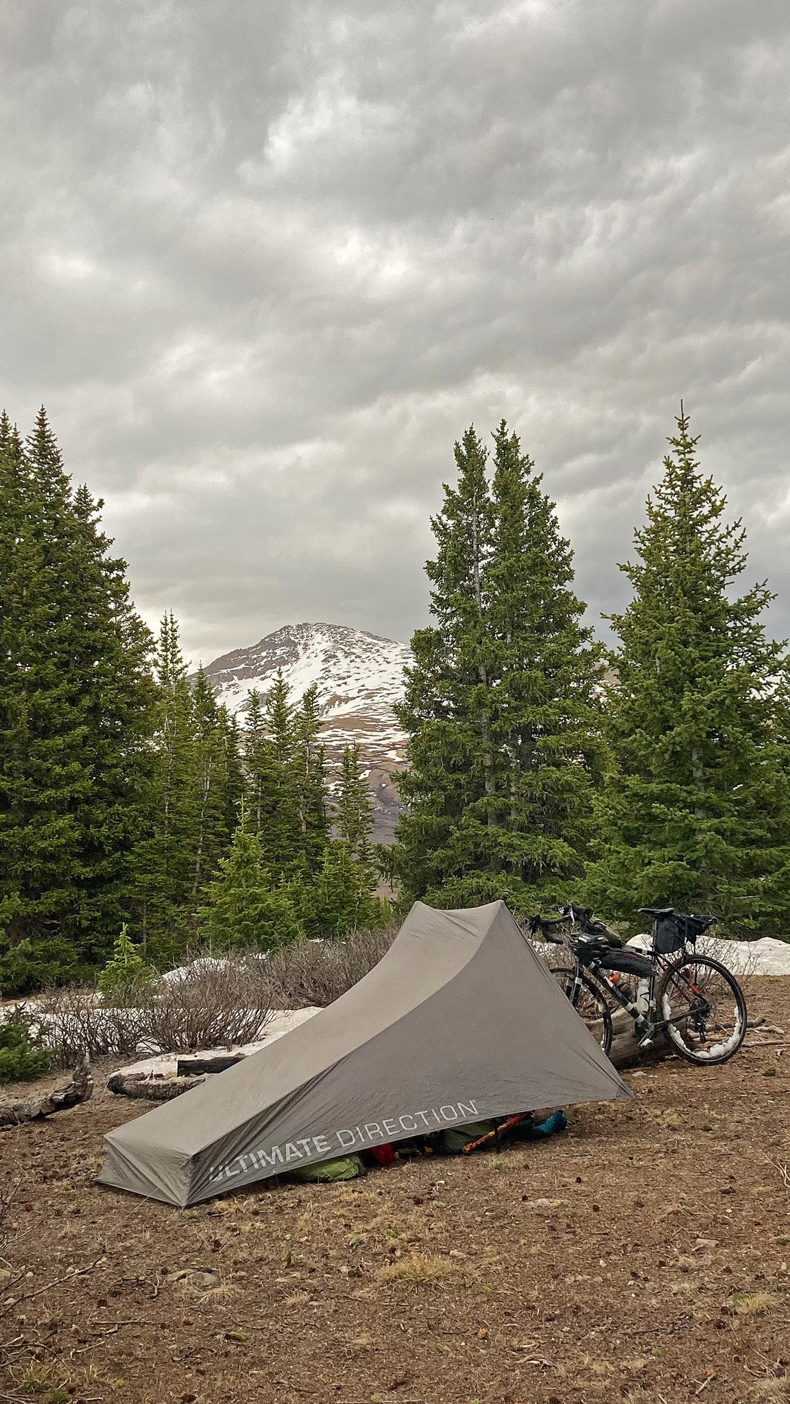
- Camping at the summit of Guanella Pass
A small, flat dispersed campsite area can be found on the west side of Guanella Pass. From the Square Top Trailhead parking lot, find a social trail heading north, and take it to a small outcrop of trees. This dispersed campsite isn’t 1/4 mile from the road, but it is beyond the line of sight from the road. And since you’re both using the Bierstadt Trail, and traveling through the area, you should be exempted to the dispersed camping restrictions, as is noted in Footnote #2- Coords: 39°36’07”, -105°42’52”
- Forest Road 118E
From Grant, FR118E is ~ 5 miles up and is on the west side of the road. - Forest Road 119
From Grant, FR 119 is ~5 miles up and on the west side of the road. Ride a mile past the NFS Campsite up the road and find the numbered camping sites.
From either of these two roads, it’s ~7.5 – 8 miles with 2,000′ of gain to Guanella Pass and the TH for Mt. Bierstadt.
NFS Camping (Fee Areas)
- Guanella Pass Campground ($$$)
recreation.gov/camping/campgrounds/232306
Guanella Pass Campground is located on the northern side of Guanella Pass, but is closer to the pass itself at only ~2 miles and 1100′ of elevation gain. Potable water is also available. If you don’t feel like reclimbing back up to Guanella Pass after riding up it from the south, the chances of hitching a ride back up in the morning are in your favor.
Road Narrative
- Mileage: 90 miles
- Elevation Gain/Loss: +6830′ -4855′
The Road version of Segment #2 closely mirrors the MTB narrative. Follow the MTB Narrative up into Tarryall Road to the Stage Stop Saloon.
After the Stage Stop Saloon, continue on Tarryall Road to it’s terminus at the small town of Jefferson, rather than taking on the Colorado Trail.
Jefferson Services
- Restaurant: Hungry Moose
38539 US Highway 285 - Grocery: Jefferson Market
38600 Colorado Highway 285
jeffersonmarket17.com
Once you’ve overindulged on fudge, continue up HW 285 on a good shoulder to Kenosha Pass. Rejoin the MTB Route and Narrative.
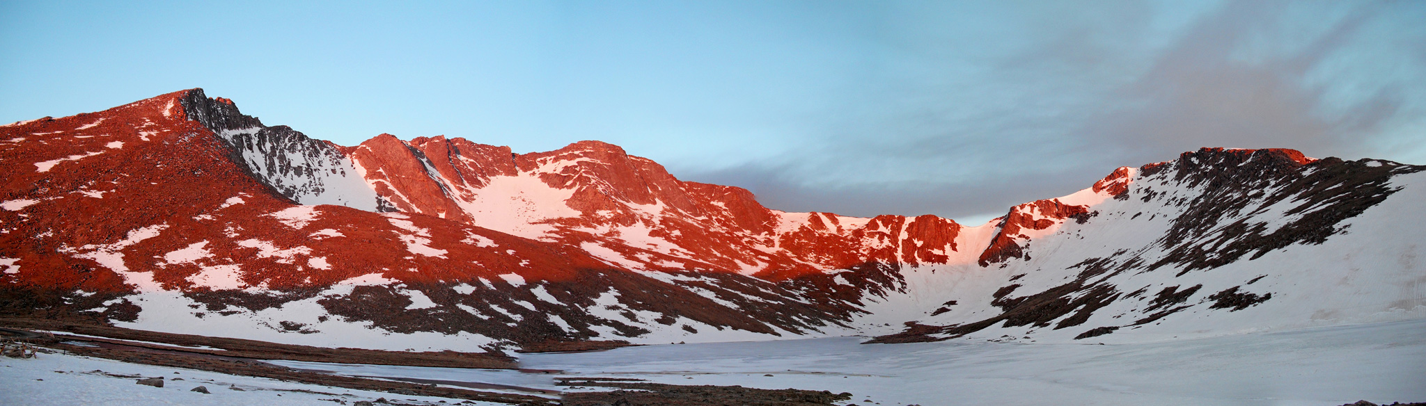
Hiking: Guanella Pass Trailhead to Mt. Bierstadt + Mt. Evans
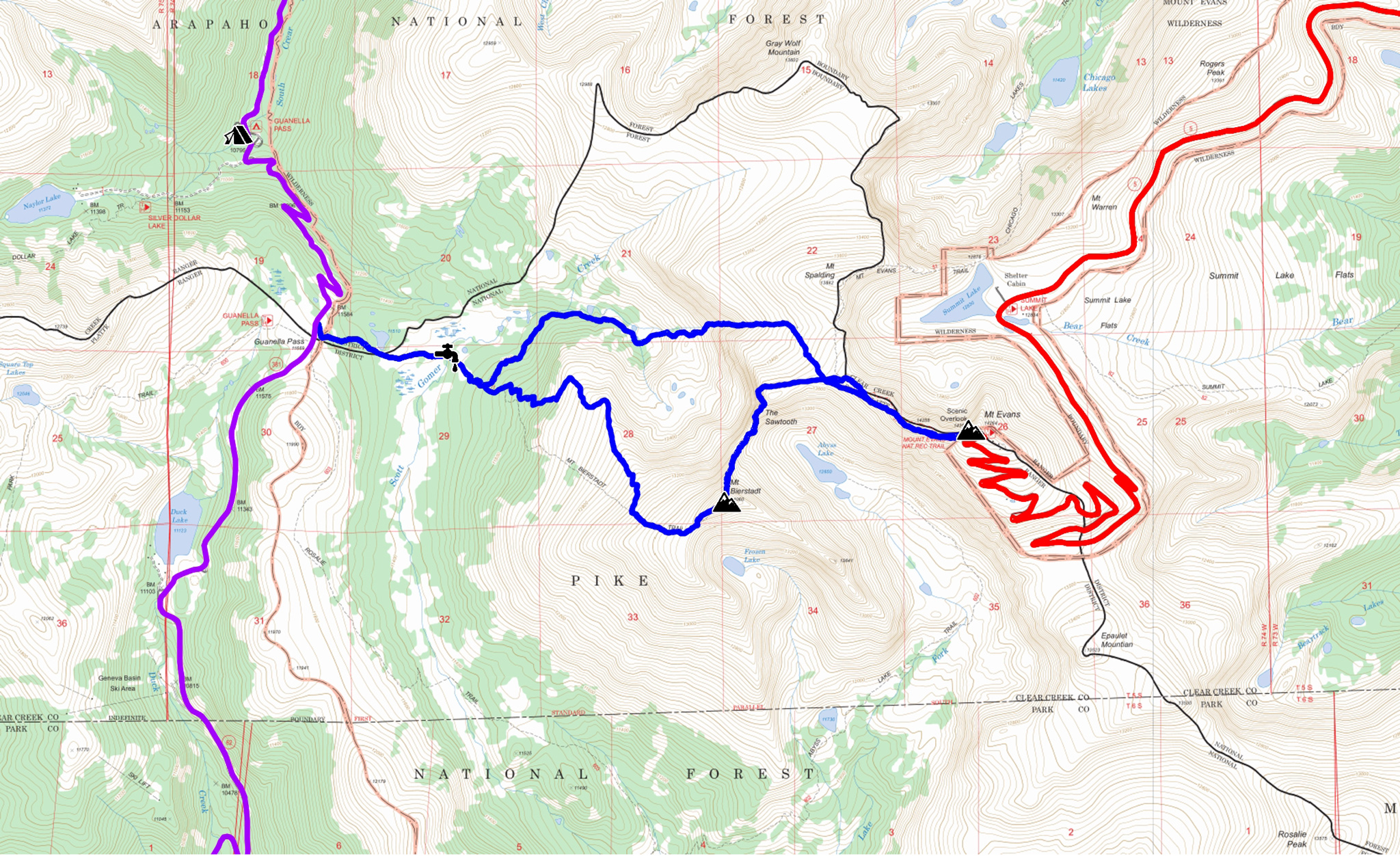
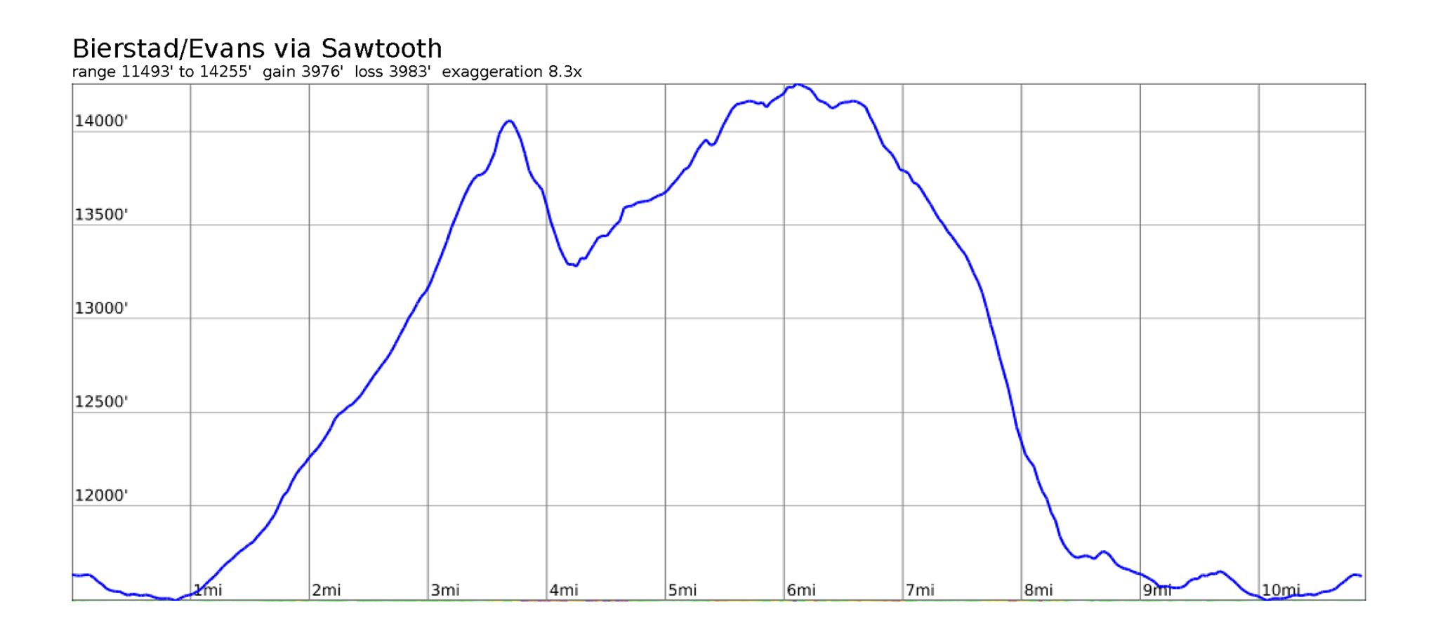
- Rating: Class 3
- Mileage: 11 miles (round trip)
- Elevation Gain/Loss: +3979’/-3985′ (round trip)
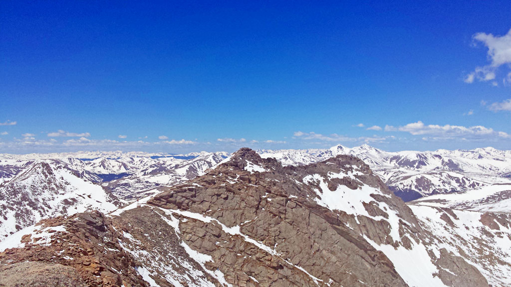
Mt. Bierstadt is one of the most visited 14ers in the state, and its west slopes route is one of the easiest 14er hikes there is. You’ll have plenty of company, so get ready to tell everyone of your self-powered trip to get a surprising reaction.
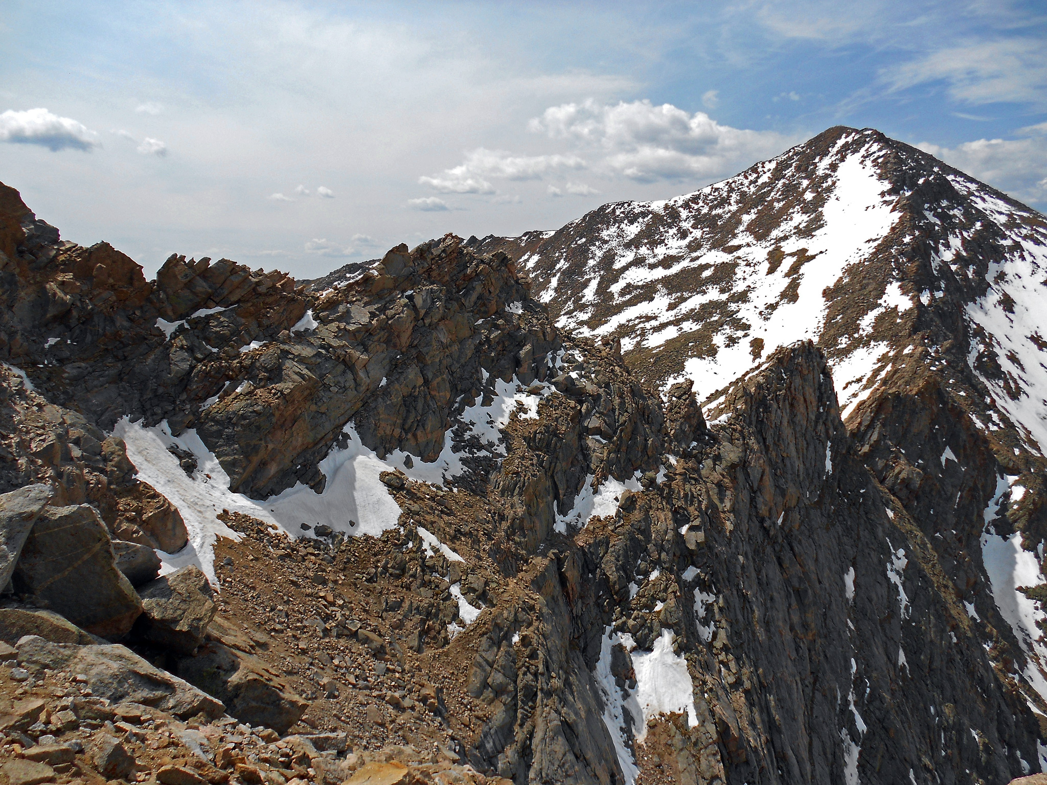
Mt Evans can be access from the summit of Mt. Bierstadt via the Sawtooth Ridge. The west slopes route up Mt. Bierstadt is easy Class 2, the Sawtooth Ridge route is Class 3. If you are comfortable with that level of scrambling and the weather seems to be holding, go off and tag Mt. Evans as well. The descent off of Mt. Evans western slopes is an interesting adventure in of itself, filled with massive stands of fire-breathing willows (fire-breathing not confirmed). The west slopes route up Mt. Evans is also an option to do on its own.
If only Mt. Bierstadt is in the cards for you, you can tag Mt. Evans later on once you make it to Idaho Springs. Mt. Evans, like Pikes Peak has a paved road to almost its summit that makes a ultra-classic hill climb.
Do note that both mountains are in the Mt. Evans Wilderness Area, so no bikes will be allowed on trail – lock up the bikes at the TH.
Aprés Hike
Camping for the night can be done back at your last campsite. Down Guanella Pass, you’ll soon reach the town of Georgetown where most services are allowed, but little free camping is available on route.
Segment #3’s MTB narrative will go up Leavenworth Road to the top of 13,000’+ of Argentine Pass; the road narrative will visit Grays/Torreys via Stevens Gulch.
Footnotes
Designated dispersed campsiteson the South Platte RD, Pike National ForestGeneva Creek Road #119From Denver, travel south on Highway 285 through Pine Junction and Bailey. Continue on Highway 285 to the town of Grant, turn right on Park County Road 62 (Geneva Rd) and continue for approximately 5 miles. Make a left on Forest Road119; continue 1 mile past the Geneva Creek Campground and the designated dispersed campsites are identified with a signfor parking and camping. There are approximately 30 designated dispersed campsites along the road, first-come first-serve.
[2]: https://www.fs.usda.gov/Internet/FSE_DOCUMENTS/fseprd577265.pdf
Guanella Pass Road (Clear Creek County Road 381):
No camping, or campfires and use after sundown and before sunrise allowed within ¼ mile of the centerline of the Guanella Pass Scenic and Historic Byway from Georgetown to the summit of Guanella Pass. This includes portions of the Leavenworth road, NFSR 248.1 and all of the Silver Dollar Lake road, NFSR 243.3D.Parking of vehicles are allowed in posted signed pullouts and trailheads.
Exception to the order are as follows; Persons using the Mount Bierstadt trail #711, Persons who are camping or visiting a person(s) camping in a Forest Service designated and provided campground in that area, and persons traveling or driving through the area.
Work in Progress
Bikepacking to the Colorado 14ers is currently being written and published publicly. Get news and updates by joining the Facebook group, Follow us on Instagram, join our subreddit, and mailing list.
You can support its development by purchasing items through the affiliate links on this site: check out the gear reviews, as well as the items below: