Work in Progress
Bikepacking to the Colorado 14ers is currently being written and published publicly. Get news and updates by joining the Facebook group, Instagram, Twitter, subreddit, and mailing list.
Introduction
A proper long haul to the northernmost 14er in Colorado: Longs Peak! Anticipate beaucoup amount of pedaling to get there. The MTB narrative will feature some of the most technical trails of the entire tour (with easy bailouts to the Road narrative, if you choose); the Road narrative itself features some extra classic tarmac cycling on the Peak to Peak Highway! Saving the best for last, Segment #4 will end at the foot of Longs Peak, the most exciting peak of the Front Range 14er tour.
Segment #4 also has an alternative track up Mt. Evans. Ride up to the summit of the mountain itself via the Mt. Evans Road!
Town resupply will be fairly easy to take advantage of, so not as much surface water will need to be collected. Free camping is a little tight near the East Longs Peak Trailhead, so make sure to have a plan where you’re going lay down your bedroll beforehand. We’ve highlighted a few free dispersed campsites, as well as noted the USFS campsites in the area.
MTB Narrative
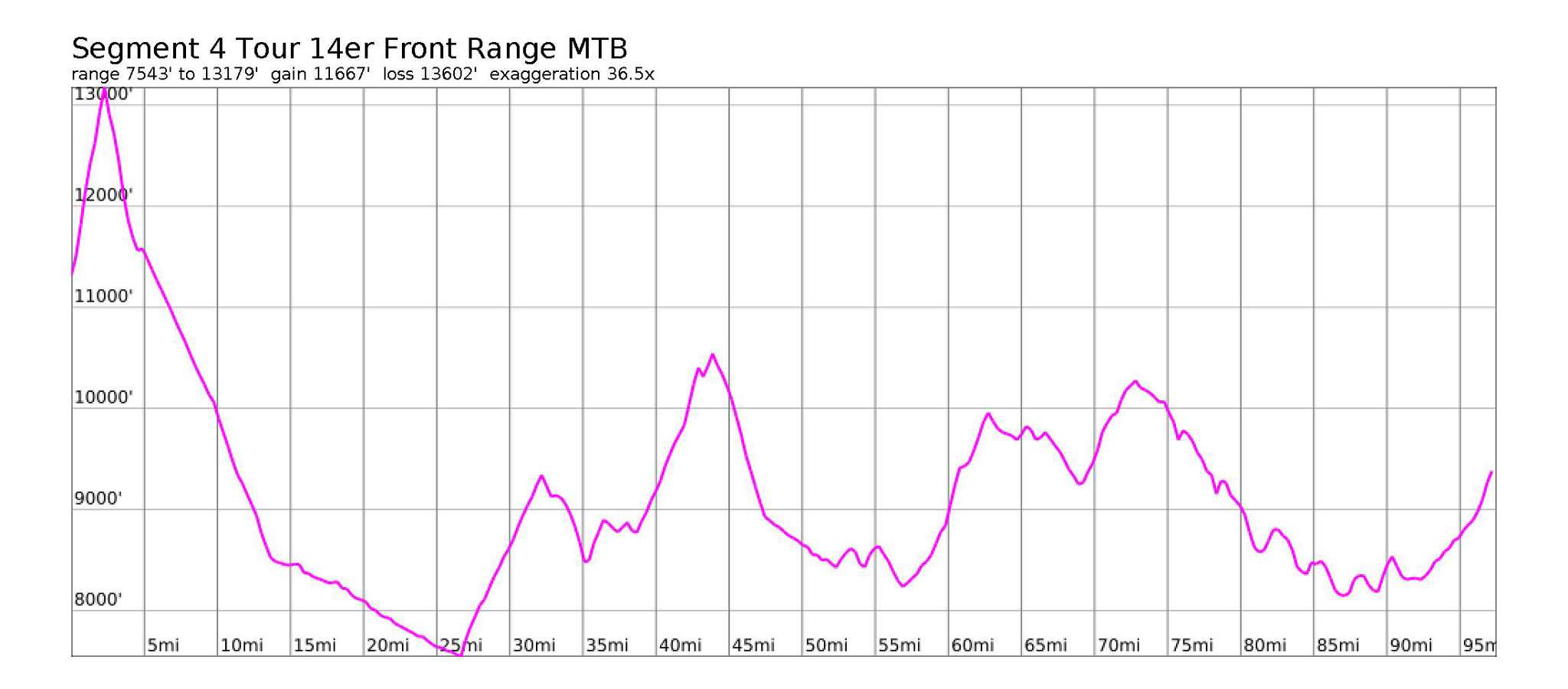
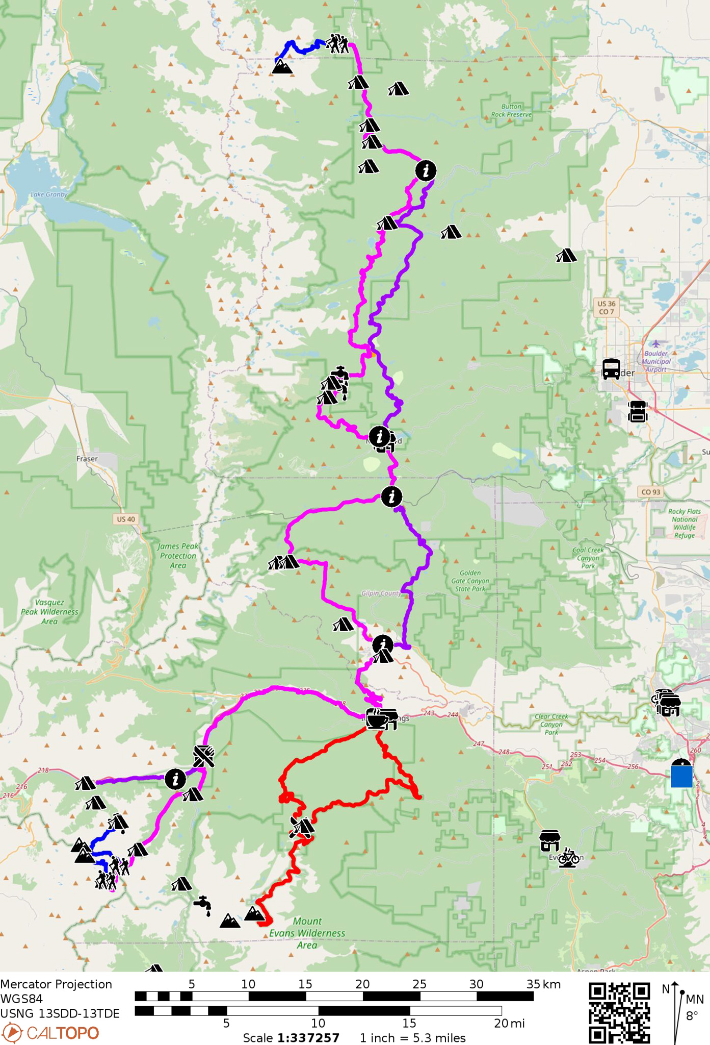
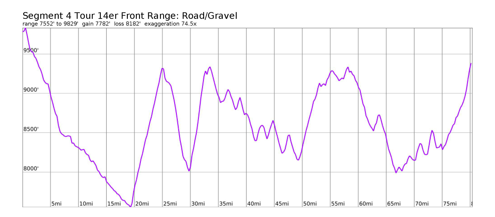
- Mileage: 97.51 miles
- Elevation Gain/Loss: 11,667’/13602′
This segment officially begins in Horseshoe Basin on the west side of the Continental Divide, although you may have stopped before on the other side of Argentine Pass near the Waldorf Mine, depending on where you decided to start your hike up for Grays and Torreys. Wherever you spent the night, backtrack on the Segment #3 route all the way to Georgetown.
If you’re getting a little low on supplies, consider grabbing something in town (See Segment #3 for Georgetown Services), but if you can hold off, continue onto Idaho Springs east via the I-70 corridor bike route where selection will be better. It’s mostly downhill to Idaho Springs.
Idaho Springs Services
Many restaurants are available on the main drag of Idaho Springs. Local, small businesses are mostly on the west side of town; chain restaurants and less expensive food options are located on the east.
- Coffee: The Frothy Cup
1510 Miner Street
https://www.thefrothycup.com - Grocery: Safeway
2425 Miner St - Outdoor Gear: Clear Creek Outdoors
1524 Miner St
(303) 567-1500 - Outdoor Gear: FERAL
1630 Miner St
(303) 829-5681
https://feralmountainco.com/the-idaho-springs-store/
Bailing
The Bustang West Line stops in Idaho Springs on Idaho St. and 13th. Take it east to reach Denver, or west towards Frisco/Summit County.
- Bustang West Line Schedule
https://ridebustang.com/west-line-schedule/
Make sure to top off on at least water. Food can be found in Central City, but you may not find the casino town all that welcoming to those not there to gamble their bikes away.
Find Virginia Canyon on the northeast side of town, and start up this steep road. Enjoy the array of eclectic houses. The road will turn to gravel and become steeper. Locate a switchback on your right and take it. This is Oh My God Road. You’ll find the riding much easier in grade, very picturesque views of Mt. Evans will be revealed to the south, and many mining ruins right on the route. Grind up the hill, and relax as the noise of the busy interstate is left far below.
After a few switchbacks, the road will straighten out and the pavement will come back, turning into CR 279. Careful with private property in this area, as the locals are quite vocal about such things.
Follow CR 279 as it continues north, then turns east. You’ll cross over the Million Dollar Highway, then descend down into the gambling town of Central City. Careful with traffic here, as motorists may be more preoccupied with the thrill of the rolling dice, than strange looking self-propelled visitors.
Central City Services
- Restaurant: Millie’s Restaurant
(within the casino)
https://www.easystreetcentralcity.com/ - Grocery: Annie Oakleys
135 Nevada St
Camping Near Central City
- Camping Denver West / Central City KOA Holiday
605 Lake Gulch Rd
(303) 582-3043 - USFS Columbine Campground
2987 Bald Mountain Rd
https://www.recreation.gov/camping/campgrounds/232381
Continue on Spring Street, and turn left on Eureka Street taking this out of town west. Eureka Street turns into CR 3 and heads north. Continue on CR 3/Upper Apex Valley Road, which wanders a bit in the hills, until it merges with Apex Valley road, and heads west, then back again north. Reach the ghost town of Apex (no services).
Make a hard left west on CR-4/Elk Park Road, and grind up a stout hill and out of Apex. The road takes a hard right and starts up north. For dispersed camping, continue straight on the 4WD track, Kingston Peak Road. Continue on this same track for a side adventure up James Peak, elevation 13,301′. James Peak is the largest peak in its namesake Wilderness Area. Make sure to leave the bike before crossing into Wilderness.
Continue north on CR-4 until you exit onto the East Portal Road near Tolland. Take a right and head east out towards Rollinsville and CO 119. Take a left on CO 119 north towards Nederland.
Nederland is a good place to resupply right before finding a place to camp for the night. Camping will be easy to find, but is also quite popular in the area.
Nederland Services
- Coffee: Salto Coffee Works
112 E 2nd St
https://saltocoffeeworks.com - Bike Shop: Tin Shed Sports
112 E 2nd St
https://www.tinshedsports.com - Grocery: B & F Mountain Market
60 Lakeview Dr
Camping
- Dispersed Camping off of FS 505
39.9951, -105.5687 - Dispersed Camping off of CR 116
40.0069, -105.5649
Bailing
- NB Bus Route
https://www.rtd-denver.com/app/route/NB/schedule
The NB RTD bus route runs from Nederland to Boulder, and from Boulder, you can reach the rest of the RTD and Bustang network by taking the Flatiron Flyer to Denver. Gear shops and most all other supplies will be found in Boulder. It’s not suggested that you cycle down Boulder Canyon, due to the heavy traffic. Several routes to Longs Peak also start from Boulder – see the entire Longs Peak Bikepacking Route Network.
Continue north on CO 119 through Nederland. At the traffic circle, and head west on CO 72. At the switchback at the far end of town, take a hard left onto CR 128/Caribou Road and start once again climbing west.
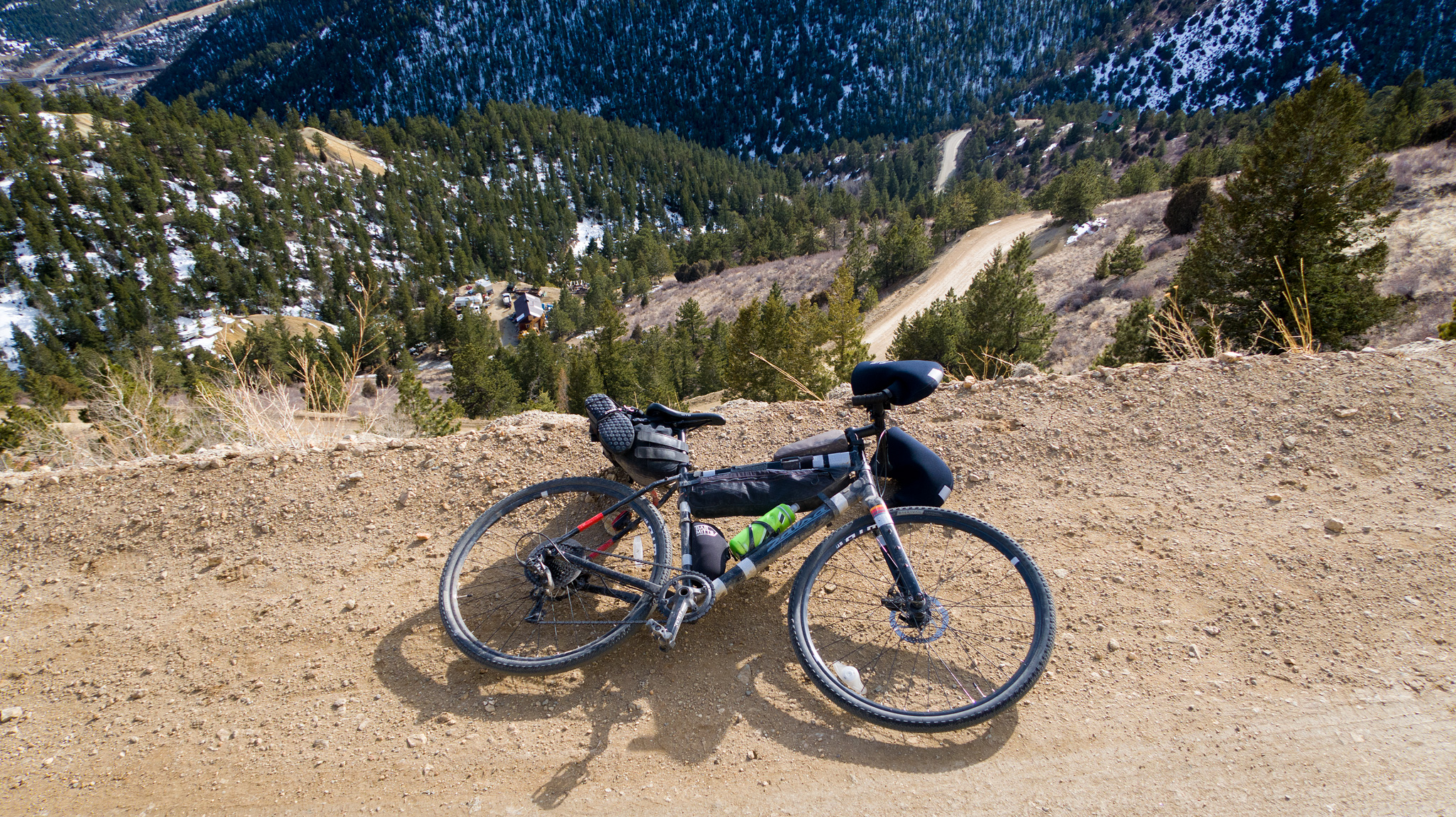
You’ll reach a junction near the Caribou mining site. Head north at the start of FS 505. The easy gravel will be replaced with an honest 4WD track. Dispersed camping and water will be easily be found off of this track. Expect some company and make some friends! FS 505 is deeply rutted and hilarity will ensue as you attempt to clear some of the larger mini-canyons.
Follow FS 505 until the junction of CR 116. Take CR 116 right and head northeast all the way to the south trailhead for the South Sourdough Trail. This trail can be difficult and at times: a hike-a-bike. It’s legitimate alpine single track. If you’re not up to this, continue on CR 116 east to its terminus at CO 72, and take CO 72 north farther up the route. CO 72 is used in the Road narrative. Consult the map for various places to hop back and forth between narratives on the rest of this segment.
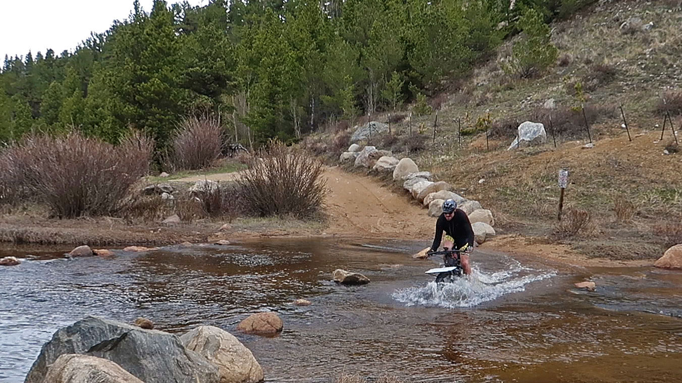
Take the South Sourdough Trail north. Sourdough will be one of the riding highlights of this segment, so relish the difficulty. The trail will cross over Brainard Lake Road.
If one desires, one can follow the Brainard Lake Road east to CO 72, and join up with the Road Narrative just above the town of Ward. Ward also has a small mercantile to get snacks and top off water.
Continue north on the North Sourdough Trail. Cross over the Saint Vrain trail. At the junction with the Wapiti Trail, continue east on the South St. Vrain trail. You’ll hit yet another junction with the Wapiti trail, and once again, continue east on the Sourdough Trail. The trail will cross over CR 96, continue north.
Nearby Camping
- USFS Peaceful Valley
https://www.recreation.gov/camping/campgrounds/232368
The trail will end at CR 92 at the USFS Peaceful Valley campsite. Turn left on CR 92 and head west for just a minute, then locate a rough, 4WD track (FS 105/Bunce School) on the right hand side, and start on up it! This track will take you northwards, until it ends on CO 7. Say, “farewell!” to the dirt on this segment.
Turn left on CO 7, and head north. You’ll soon reach the small town of Allenspark. Services are limited, and open times can be flexible (to the store owners!), so don’t count of them as a reliable resupply:
Allenspark Services
- Food: Rock Creek Tavern & Pizzeria
6 Ski Rd E - Meadow Mountain Cafe
441 CO-7 (Business) - Ferncliff Food & Fuel
083 CO-7 (Business)
Camping
- USFS Olive Ridge Campground
CO-7 Scenic
https://www.recreation.gov/camping/campgrounds/232281 - Ski Road Dispersed Camping
Ski Road
40.1769, -105.5262 - FS 204 Dispersed Camping
40.1960, -105.5227
There will be only one more option for dispersed camping before the trailhead, located a file miles off the route, as private property will encroach the area.
Continue north on CO 7. Enter the small enclave of Meeker Park.
Meeker Park Services
- Lodging + Food: Meeker Park Lodge
11733 Colorado Highway #7
(303) 747-2266
As well as being a small, self-contained resort, Meeker Park Lodge also has a small grocery store/pantry one would expect from a private campsite, as well as a Pepsi machine that’s accessible 24/7. Take off your shoes before entering if they’re cleated!
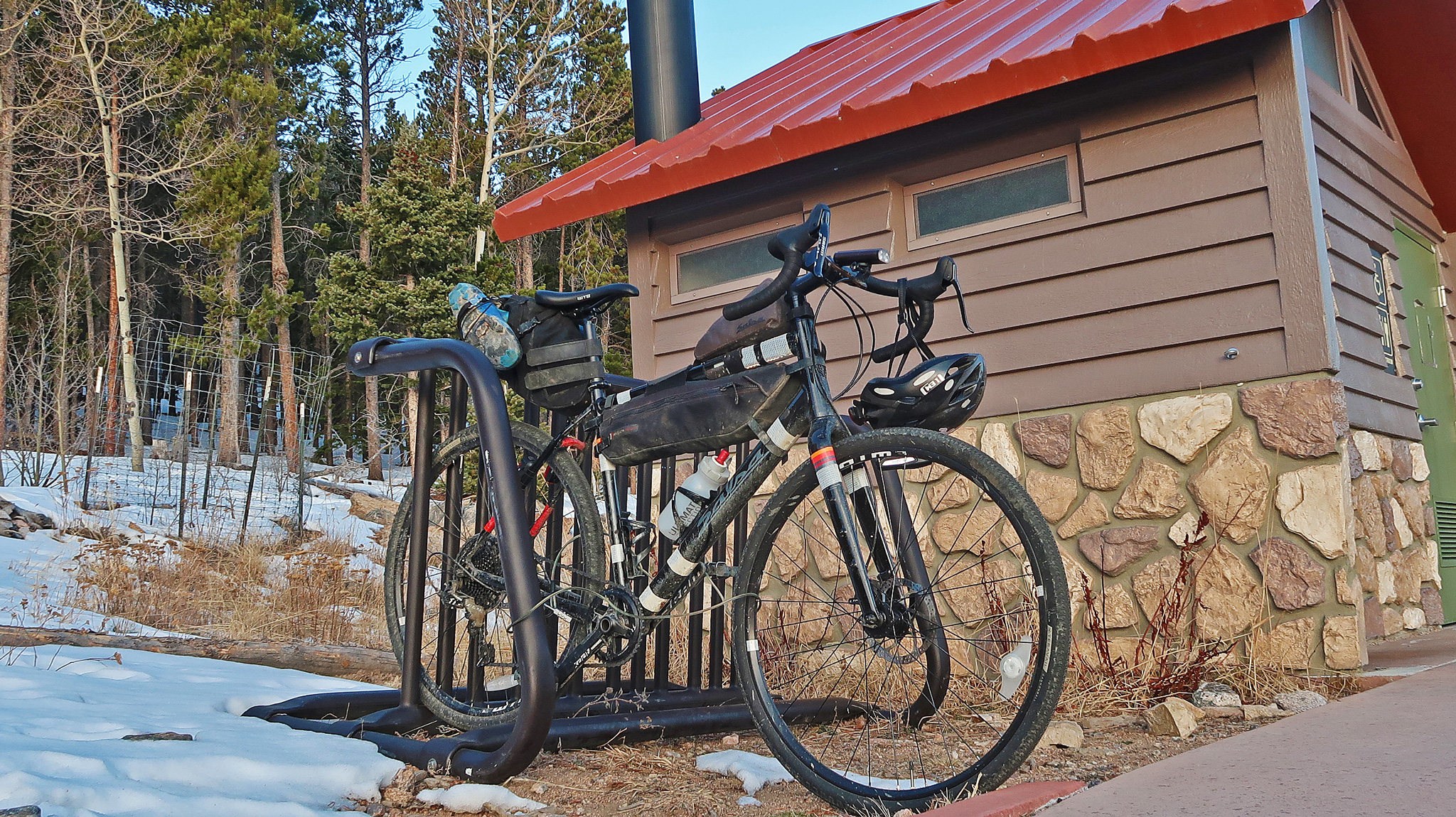
Continue north on CO 7 until the Longs Peak Road. Turn left on the Longs Peak Road at mile marker 9. It’s a mile to the East Longs Peak TH. There is a first come, first serve campsite run by Rocky Mountain National Park right next to the trailhead, but it does fill up quickly.
Camping Near East Longs Peak TH
(Backcountry camping within RMNP requires a permit. Please do not poach a bivy within the Park.)
- Longs Peak Campground
https://www.nps.gov/romo/planyourvisit/lpcg.htm - USFS Meeker Park Campground
https://www.recreation.gov/camping/poi/241175 - Dispersed Camping off FS 119
40.2376, -105.4954
Road Narrative
- Mileage: 80.42 miles
- Elevation Gain/Loss: 7782’/8182′
Segment #3 ends at either the summer or winter trailhead for Grays and Torreys Peaks. Just like the MTB narrative, make your way back to Georgetown, by backtracking Segment #3. Follow the MTB narrative to Idaho Springs, up Oh My God Road and into Central City. You’ll hit a ton of delicious, well-maintained gravel, but will leave it all after Central City for good tarmac, with a reasonable shoulder and some incredible views of the Continental Divide.
At Central City, instead of turning left to go up Eureka Street as the MTB narrative does, turn right onto Gregory Street east towards Black Hawk. Before getting into the main business of Black Hawk, turn right onto Bobtail Road which will detour you around most of the hotels and casinos and land you on HW 119. A “no bikes” sign should block your way at this intersection as well as police car that may or may not be occupied by a dummy officer.
Take a left on CO 119 west, then turn right and head north on Richmond Street. Richmond is a paved, albeit rough and steep road that’ll allow you to miss much of the traffic on CO 119. The road will end at Golden Gate Canyon Road. Take a left onto Golden Gate Canyon Road heading west until it itself ends back at CO 119. Take a right on CO 119 and head north.
You’ll be taking CO 119 for a good while, meeting back up with the MTB route in Rollinsville, then paralleling with it into Nederland. Stock up on supplies in Nederland and continue to the north side of town.
At the traffic circle, turn left onto CO 72 heading west. CO 72 will switchback up a hill, going north. Follow CO 72 until it crosses Sugarloaf Road, found on the right hand side, and turn left afterwards onto CR 103 found on the left hand side of the road. This well-maintained gravel road will give you a small reprieve from highway riding. Continue on CR 103 until it once again meets up with CO 72, and turn left onto CO 72, heading north.
Pass just above the town of Ward.
Ward Services
- Groceries: Utica Street Market
62 Utica St
Continue on CO 72. Pass Brainard Lake Road.
Continue north on CO 72, until it junctions with CO 7. Turn left at the intersection to enter onto CO 7. About a mile later, you’ll pass Bunce School Road, where the Road and MTB routes once again converge.
The Road and MTB narrative finish together. Finish the segment by following the MTB narrative by continuing up CO 7 to the Longs Peak Road. Camping and additional services are described in the MTB narrative.
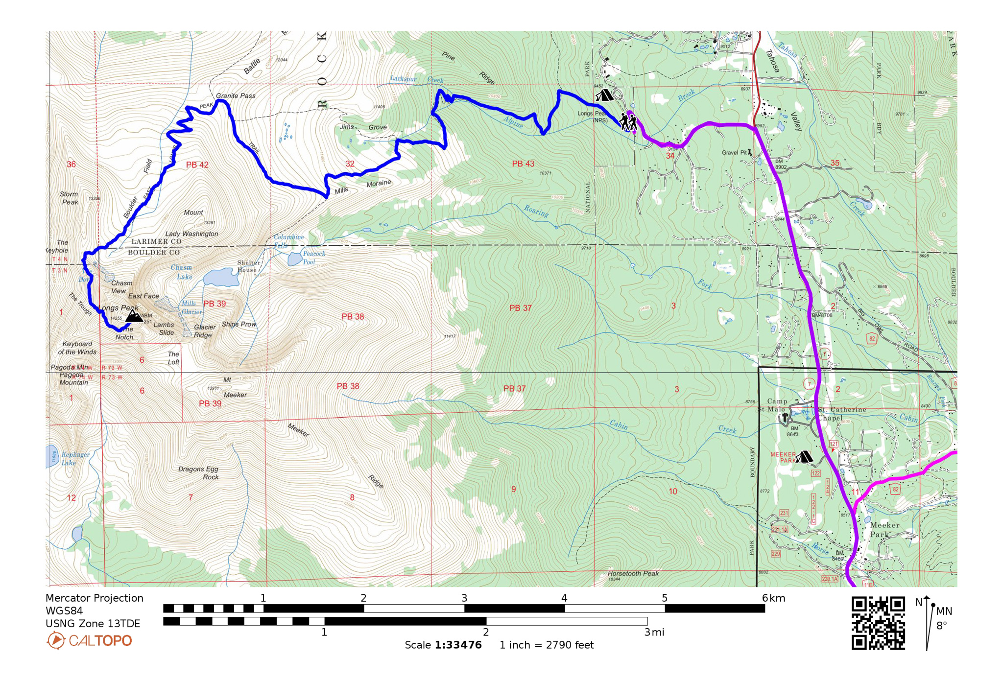
Hiking: Longs Peak via Keyhole
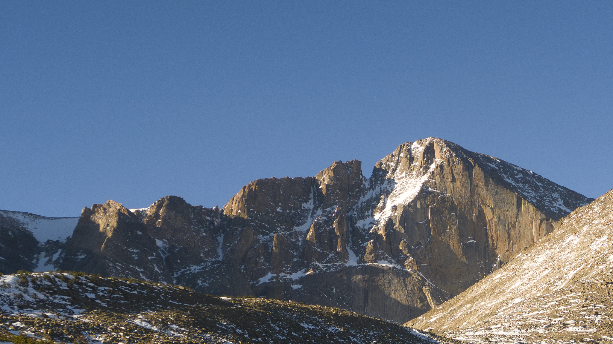
Longs Peak will definitely be the most exciting and spectacular mountain to summit in the Front Range 14ers.

- Rating: Class 3
- Mileage: 6.7 miles (one way)
- Elevation Gain/Loss: +5095’/-233′ (one way)
Refer to the 14ers.com route narrative for the Keyhole Route.
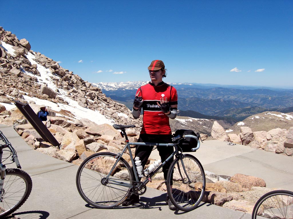
Highlighted Alternative: Mt. Evans via the Mt. Evans Road

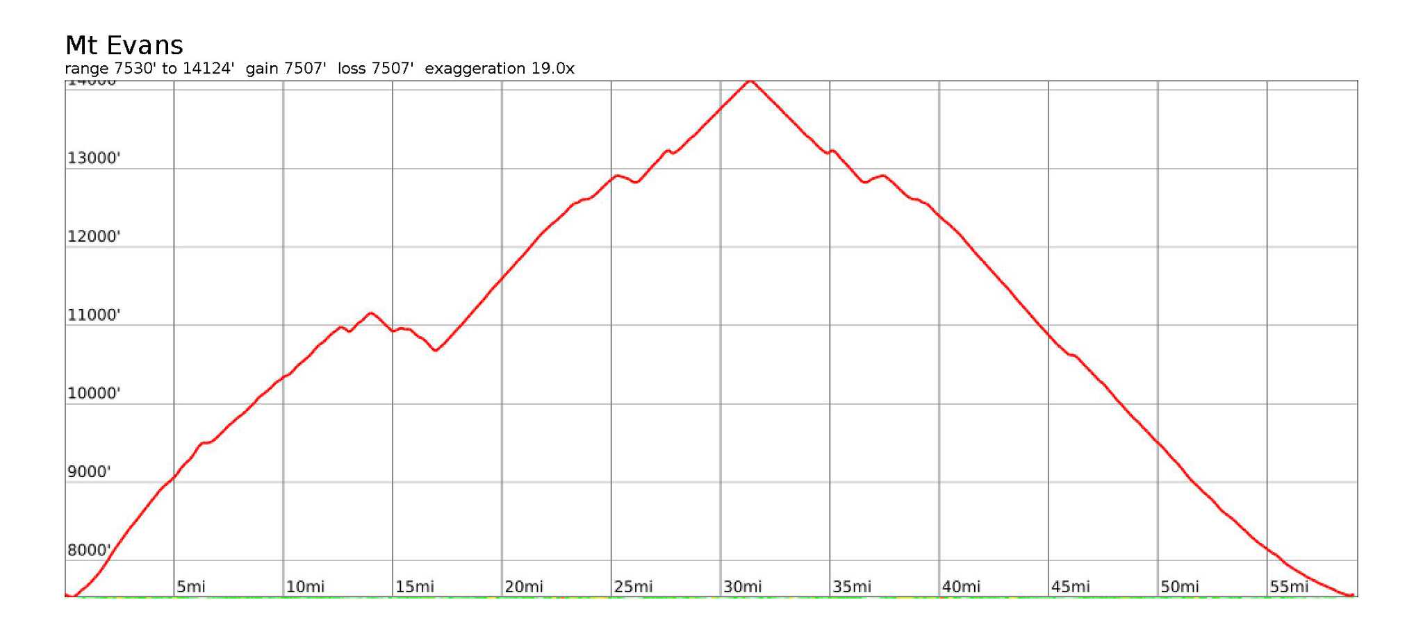
- Surface: pavement
- Mileage: 59.17 miles (round trip)
- Elevation Gain/Loss: +7508‘ –7508‘ (round trip)
Mt. Evans actually has a paved road – the highest paved road in North America, that goes almost all the way to the summit of the mountain itself and it’s open to cycling! One can’t create a cycling route to all the 14ers on the Front Range, without mentioning this ultra-classic road route. This is a worthwhile alternative to summiting Mt. Evans, without having to traverse across the Sawtooth (See Segment #2).
We’ll start our alternative narrative in the town of Idaho Springs, and take a somewhat alternative start to keep things interesting.
(You may also simply take CO 103 south towards Echo Lake/Mt. Evans and rejoin our narrative there.)
Starting in Idaho Springs, look for signs for the Indian Hot Springs off of Soda Creek Springs Road, and take this road south, past the hot springs themselves. The road will soon turn to well-maintained gravel. Bear left onto Little Bear Creek Road which will start switchbacking up the hillside. Take this road all the way to CO 103/Squaw Pass, then turn right onto CO 103 heading west.
CO 103 will climb for just a bit, before descending right into the Echo Lake area and the start of the Mt. Evans Road, which you’ll find on your left. Turn onto the Mt. Evans Road, and start up!
Echo Lake Services
- Restaurant/Food: Echo Lake Lodge
https://echolakelodgeco.com
Echo Lake Camping
- USFS Echo Lake Campground
https://www.recreation.gov/camping/campgrounds/231857
It’s 13+ miles on the Mt. Evans Road from the start gate and almost 4,000′ of elevation gain. Get an early start and pace yourself! The last few steps to the summit will have to be done by foot. Watch out for errant mountain goats littering the road.
Descent the Mt. Evans Road back to the Echo Lake Lodge, then take a left on CO 103 and head north towards Idaho Springs. Re-join the main narratives in Idaho Springs.
Work in Progress
Bikepacking to the Colorado 14ers is currently being written and published publicly. Get news and updates by joining the Facebook group, Follow us on Instagram, join our subreddit, and mailing list.
You can support its development by purchasing items through the affiliate links on this site: check out the gear reviews, as well as the items below: