What is Slowlans?
SLOWLANS: an off-trail, ultralight backpacking guide of the Nolan’s 14 line!
Nolan’s 14 is a Colorado mountain running/mountaineering challenge: link the fourteen Sawatch Range 14ers (Mount of the Holy Cross, the 15th, is omitted) by foot as fast as you can, historically within a 60 hour cutoff. Quite popular as FKT challenges go, the route also can be attractive to advanced ultralight backpackers who have off-trail experience. Instead of running the route as fast as you can, backpack it at your own pace.
The terrain is challenging, the elevation gain/loss is frightening, the route is unforgettable.
What The Slowlans Guide Covers
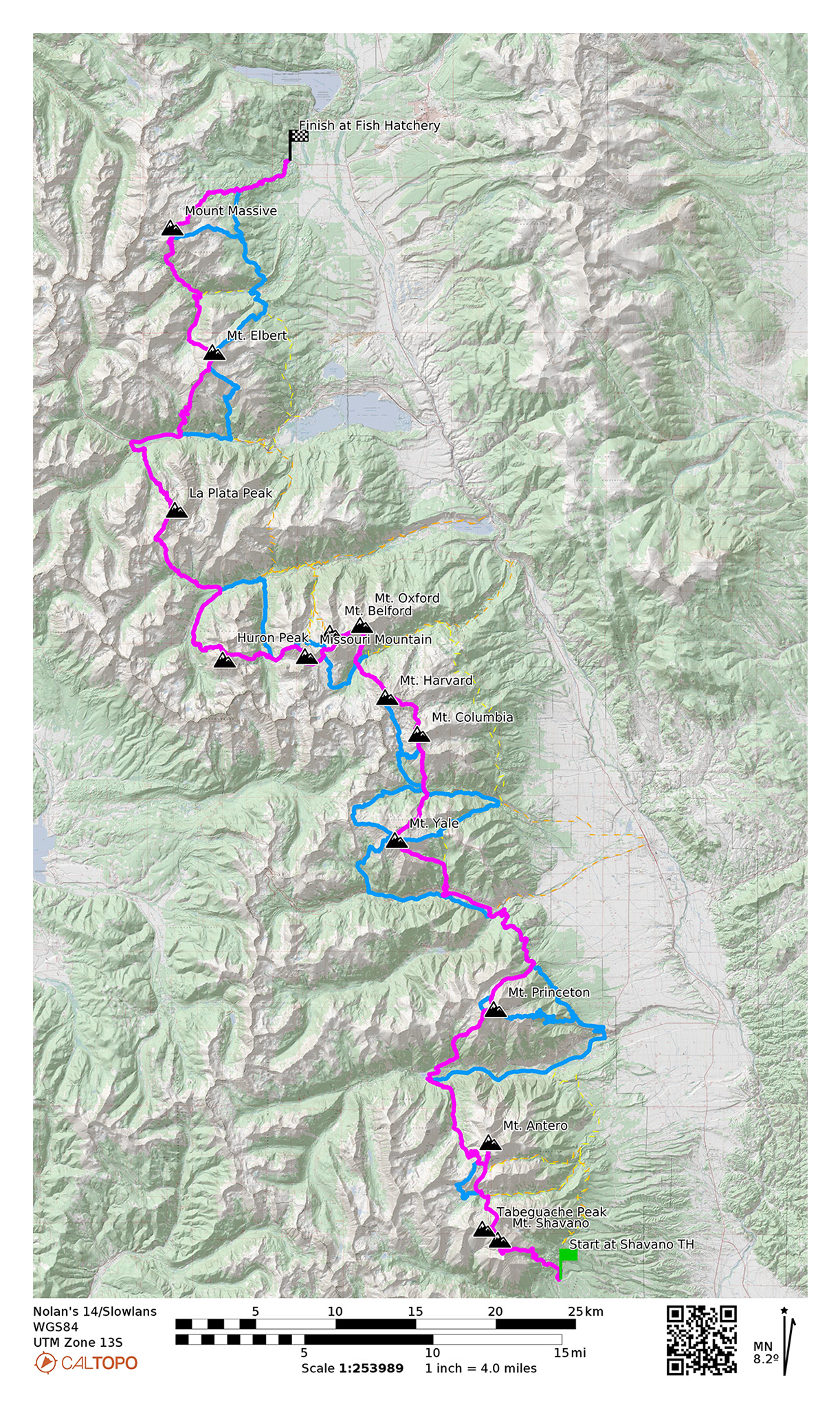
Each segment of the Slowlans route is described going South to North, starting at the Shavano Trailhead and ending at the Leadville Fish Hatchery, with a bonus extension to Mt. of the Holy Cross. The most direct line generally used for Nolan’s 14 runs is described first, then any other more manageable alternatives that may be available will be introduced: the Slowlans Alternatives.
Details on how to skip peaks if bad weather is rising or morale is low, and options on how to bail from the line completely back to civilization will also be described, as well as good water sources, places to leave your own caches, and places to camp for the night.
With this information, you can then piece your own version of a trip on the Nolan’s 14/Slowlans Spectrum.
This guide has primarily two main pieces:
Caltopo Map
The Caltopo map will have an interpretation of a Nolan’s 14 route, as well as all the data described. Study this map on your computer to use as a planning tool, load this map up on your phone using the Caltopo app to utilize in the field, export the data to a standalone GPS device as an alternative, or fork the data to use as a basis of your own map using whatever software you’d like.
Route Narrative
The Route Narrative gives you an overview of what to expect on each segment. An overview map is provided and some basic mileage and elevation gain/loss data. The written narrative itself will divulge some details of the route to get you ready for what’s ahead, as well as make sure you know what’s available in sections coming up
Trip Itineraries
Finally, suggestions are given for different length trip itineraries, and some example trips taken to give you an idea on what to expect to cover in those time frames.
Above all: BE FLEXIBLE with your Slowlans trip! It’s going to be a wild route full of surprises.
Route Description
The classic Nolan’s 14 line is comprised of both extremely well-maintained on-trail routes up 14ers, as well as off-trail routes of varying quality. Some of these off-trail routes are undocumented social, game, and hunting trails; others ascend/descend steep avalanche chutes and hillsides that may take considerably more route finding skills to navigate safely and efficiently. Prepare yourself for moderate isolation bushwhacking up and down lonely slopes, as well as sharing well-engineered trails with other trail users.
Generally, a mountain or group of mountains will first have to be ascended starting from the valley floor. Once summited, you’ll descend back down the other side of the mountain into a different valley/basin. Usually, good camping is available at these low points, as well as good water sources, and bailout/resupply points. For Nolan’s 14 runners, this is where you may meet up with support. We can also use these areas to stash our own cache of resupplies.
On-Trail vs Off-Trail Travel
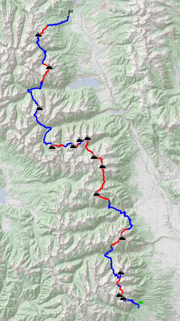
Although billed as a mostly off-trail bushwhacking adventure, the classic Nolan’s 14 line mileage-wise is actually two-thirds on-trail, with elevation gain/loss roughly split between on-trail and off-trail segments.
- On-Trail: 60.73 miles, 21,382′ gain/23,500′ loss
- Off-Trail: 33.2 miles, 23,800′ gain/21,800′ loss
Off-trail segments are going to be steeper.
The longest span of on-trail travel is around 20 miles from the summit of Mt. Huron to below Bull Hill south of Mt. Elbert. In this on-trail segment, you’ll also be following paved CO 82 for a few miles.
The longest off-trail travel is between leaving the Colorado Trail south of Mt. Yale to follow Hughes Creek, to the summit of Mt. Oxford (15 miles), although you will be on the Horn Fork Basin trail for a hot second and will have the ability to take the standard route by trail up Mt. Columbia without too big of a time/distance penalty.
Most Remote Spot
The furthest you will be from a reasonable road any car could drive to will be between Mt. Harvard and Mt. Oxford in the Pine Creek Basin. It’s over 9 miles away from US-24 by singletrack trail. This point in the basin is also the “highest lowest” point at 11,350′.
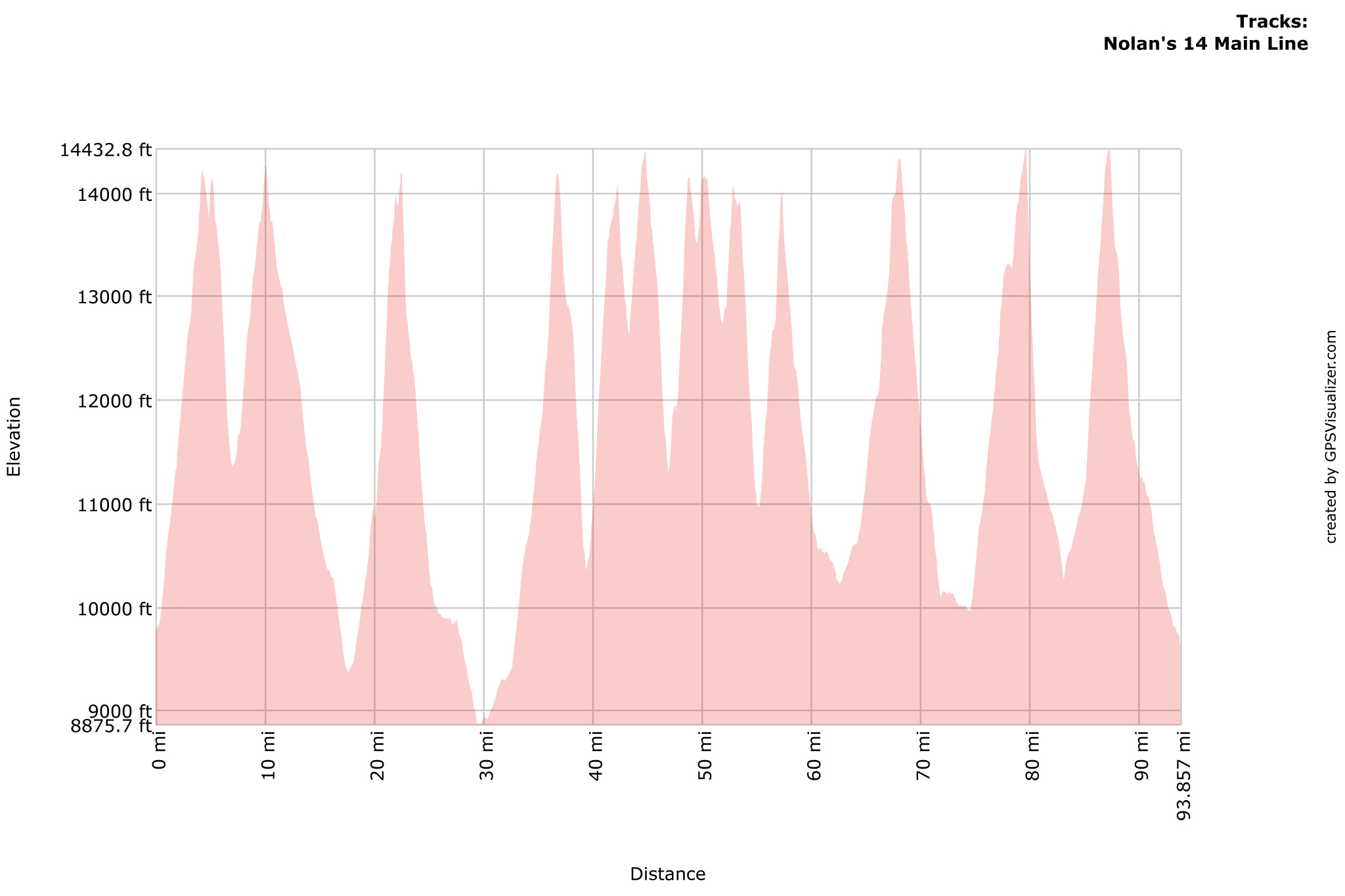
Most Elevation Gain and Loss
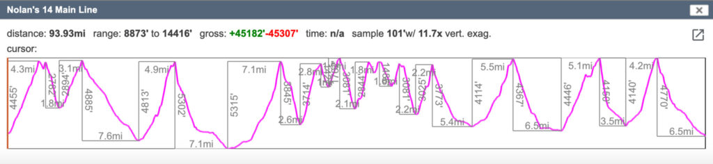
Going south to north, the greatest loss of elevation is off of Mt. Princeton, taking you down 5,302′ from the summit to South Cottonwood Creek near where the Colorado Trail crosses over CR 344 in 7.1 miles (14% grade).
The greatest gain in elevation starts at this same spot, climbing 5,315′ up to Mt. Yale in 7.1 miles (14.2%).
Steepest Climbs and Descents
On average, the steepest climb is up Mt. Huron from Clohesy Lake: 3,025′ in 2.2 miles (26.04%) and Mt. Oxford from the Pine Creek Drainage: 2,844′ of climbing in 1.8 miles (29.92%).
The steepest descents on average are descending Tabeguache: 2,782′ in 1.8 miles (29.27% average) and descending Yale: 3,845′ in 2.6 miles (30.23% average).
Highest Point
The high point of the route is Mt. Elbert at 14,438′. This is also the high point of Colorado!
Lowest Point
The CT/CR 344 point is also the low point of the route at 8,876′.
Farthest Distance Between Two 14ers
The Summit of Princeton and the Summit of Yale are the farthest two points between any of the 14ers on the route at 14.2 miles.
If counting Holy Cross, Elbert and Holy Cross are the farthest two 14ers, being 25 miles away.
Route Challenges
The technical nature in a rock-climbing sense of all these routes is particularly mild, but this does not mean the going is easy. Expect the route to be much harder than the Colorado Trail that it parallels. As a whole, the entire Nolan’s 14 line would go at YDS Class 2 at the most, except for a few feet on the southern ridge of Mt. Princeton which may go at YDS Class 3. The off-trail portions go through steep avalanche chutes with potentially loose footing, bushwhacking through thick aspen groves, and a ton of time above treeline.
That last point is particularly problematic, as Colorado’s lightning storms can be dangerous. Lots of ridge lines are also followed, exasperating the last issue. All of these aren’t impossible to deal with while backpacking, but it does perhaps suggest Plan B’s be put in place at specific parts of the route.
Another special consideration is route finding skills. Terrain can at times be challenging and not designed for enjoyment first, but rather efficiency. Backpacking this terrain will require off-trail hiking skills: the ability to read the terrain, a topo map, etc. This guide won’t allow you to simply follow a GPX track through the trail-less portions. The narratives will not give you complete turn-by-turn directions.
General Bailout/Resupply Points
Many roads cross the Sawatch Range and thus the Nolan’s 14 line and our Slowlans route. The Colorado Trail/Continental Divide Trail also parallels it. A few miles further east is a highway that also shadows the entire route. Many small towns dotting the highway are used as resupply points for thruhikers and other outdoor enthusiasts. Bailing to a trailhead with a parking lot is realistic, especially if you have a few days worth of food and camping gear with you. Thumbing a ride to town from many places is also probable, and already part of the culture of the area.
Water
Water is also plentiful on route. Even though the Nolan’s 14 line is seen as a high mountain challenge, many times you descend all the way to the valley floor, and creeks will be crossed. This helps make the line much more realistic to backpack as multi-day trips will need things like water resupply, and a good place to camp.
You will want to make sure to fill up at these creeks, as once you start ascending and definitely when you’re above treeline, water does get pretty scarce.
Skipping Peaks
Historically, Nolan’s 14 challengers often get shut down because of weather: a storm rolls in, a peak is too dangerous to ascend in lightning, a challenger’s tight timeline is blown, and they have to quit, even though their legs are still there.
But a Slowlans backpacker doesn’t need to summit every peak on their way to complete their own unique trip. Realistically, the chances of you getting shut down while summiting a 14er because of weather are very good.
There’s no reason why a backpacker can’t just keep going via a more adaptable alternative route, away from the danger of thunderstorms below treeline and on good trails. Multiple roads cross the line too, and who says your backpack doesn’t include a hitch to the next trail segment, or even back to town for some pizza and beer? All the route segments are going to be challenging, but empower yourself to not always need to take the most direct/off-trail portion. Base your decision on your own personal fitness, experience, weather, amount of pain and suffering, or any other preference you may have.
Trip Time Estimation
Estimating time to finish is going to be harder to do than on a well-trodden, completely on-trail thru hike. We don’t entirely suggest estimating trip time by mileage alone, or even when taking in elevation gain/loss, as the difficulties of the route itself may have you move at a much slower pace than you’re used to.
A mountain or a close group of mountains may be all you can realistically do in one day, as the total elevation gain can come close to 5,000′. Adding the next mountain/mountain group will double that elevation gain.
Staying on a tight time constraint is vastly simplified if you have options to skip mountains for potentially faster/easier routes, so keep those in back of your mind. You’ll most likely will be managing your expectations on what route you’ll be taking at the start of each day based on weather and fatigue. Even though some of the routes we document for skipping peaks are longer, they’re usually on good trail with less elevation gain/loss, allowing you to travel faster. You can always end early and hitch a ride to town. Roll with it!
Six day and four day trip itineraries and provided for you to get an idea of what those types of days look like. Even a six-day trip is an aggressive timeline. For anything longer than six days, considering leaving supply caches to lighten up your load, or plan on 0-days at one of the local towns. This may sound crazy for a < 100 mile route, but this route packs a lot of terrain in a small amount of length. Reassess your pace at the beginning of each morning and make a decision on if your going for more peaks, or potentially skipping.
Backpacking Gear Considerations
Oftentimes ultralight backpackers prefer lightweight gear choices to make their trip faster and more enjoyable. Given the incredible amount of elevation gain and loss of the Slowlans route, we suggest only packing what’s needed without impacting safety, to keep your pack weight low and making the off-trail segments more doable. Careful selection is needed, as you will change elevation +/- 3,000′ – 4,000′ in almost every segment of the route that we describe. Aim for a 10 lb. summer base weight, then sufficiently supplement for colder nights, higher elevation, and freak thunder/sleet/hail/rain storms. Do not camp above tree line unless you have a proven sleep system that you know will survive (and allow you to survive!) such a high camp.
Sun Protection
The high altitude, rarefied air of Colorado is also very intense in the solar energy that reaches the surface of your skin. Consider wearing sun protection-specific clothing. Temperatures can get into the 90’s at the lowest elevations of the route.
Warmth and Insulation
Remember it can snow any day of the year in Colorado, and you’ll be traveling above treeline in every segment of this route for hours on end, and topping out at 14,000’+, fourteen different times.
Shelter and Sleep System
We would suggest bringing a waterproof shelter and a sleeping bag with a limit rating of at least 32F. Almost all the campsites mentioned in this guide are below or right at treeline. Unless conditions are perfect, we do not suggest camping above treeline, especially if you’re not completely familiar with the area.
Water Treatment Options
Water quality in the Sawatch is generally quite good, but we do suggest treating all water found on the route, as you will be passing through very high use areas. Aquamira is an excellent option. Filters are also popular – just be careful when storing them when not in use, as freezing temperatures can damage the filter in ways that aren’t easily noticeable when using the filter.
Slowlans Season
For the greatest chances of success, you will want to get on route in late June, July, August, or early September. Lingering snowfields below treeline are one major obstacle that can change a Type 2 bushwhack into a Type 3 suffer fest. Nighttime temps up high also can be below freezing and can easily catch an unprepared backpacker off guard. To complicate all this, the Monsoon Season in Colorado can bring torrential rain storms and the threat of lightning in the prime backpacking season.
Traveling Mountainous Terrain in Colorado During Monsoon
Do not get stuck above treeline during a lightning storm. Start as early as possible when ascending any of the mountains in this guide and be off a summit before noon. If weather starts to roll in, bail from any summit attempts – this may mean traveling back down from where you began. Weather may clear up after a storm in the afternoon.
Leave No Trace
Subalpine and alpine terrain are delicate.
Tundra that’s been trampled on can take many years to bounce back. Human waste left above treeline may never properly decompose. Be extremely mindful on your impact while on route, and practice Leave No Trace ethics as you travel through each segment.
A great habit to get into is answering the call of nature while down low well below treeline, where a cat hole can be reasonably dug before you climb up high, keeping your impact to the environment to a minimal.
Erosion of hiking routes is a big issue when it comes to travel on Colorado’s popular 14ers. When on a marked trail, please do not cut switchbacks. Be particularly careful when traveling off of a marked trail, and most especially when traveling on tundra. The great majority of off-trail travel above treeline in this guide will be on talus – a reasonable and durable surface for hiking. We’ll note any areas where we feel extreme care will be needed.
Getting to the Start/Finish and All Points Between
Since Slowlans parallels the Colorado Trail and Continental Divide Trail as it rolls between Salida and Leadville, you can use practically all the resources set up for those trails. Particularly useful is the CT Shuttles list, which you can request here:
About the Author
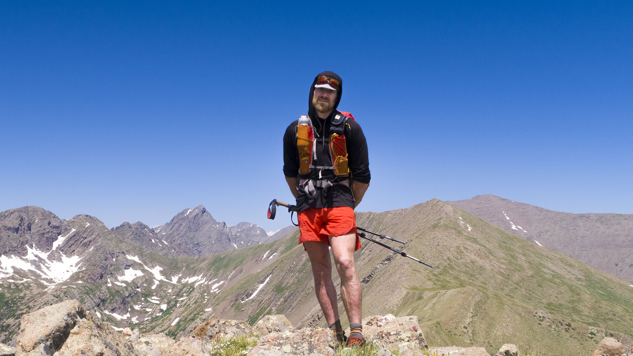
I’m Justin Simoni. I’ve been scouting the Nolan’s 14 line since 2015, and have attempted to run Nolan’s 14 under 60 hours four times. In 2022, I made completed my own Slowlans in two trips: Shavano to Belford; Missouri to Massive. I’ve summited each of the 14ers in the Sawatch range at least four times – most them many more times than that.
I’ve also completed the 58 Colorado 14ers in 34 days self-powered, the Colorado Centennials in 60 days self-powered, as well as completely traverse both the Mosquito/Tenmile Range and the Sangre de Cristo Range (twice!) by foot unsupported.
Contact
Contact me here for questions and to report errors in the guide.