Work in Progress
Bikepacking to the Colorado 14ers is currently being written and published publicly. Get news and updates by joining the Facebook group, Instagram, Twitter, subreddit, and mailing list.
Choice Trip Itineraries
Dirt
[su_qrcode data=”https://justinsimoni.com/bikepacking14ers_gpx/Longs_Peak_Choice_Trip_Dirt.gpx” size=”100″ color=”#000000″ background=”#ffffff” class=””]
Day #1
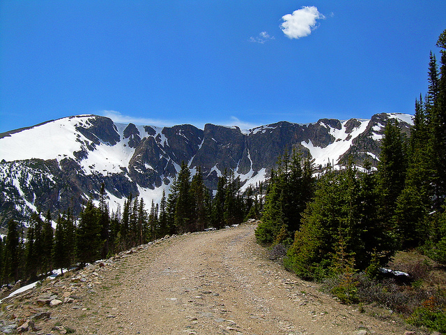
Take LP13: East Longs Peak TH via Betasso/Swiss Trail/Sourdough up towards the East Longs Peak TH. This is a full day’s ride alone. Bivy in NF at either Ski Road near Allenspark, or off of FDR 119.
Day #2
Hike Longs Peak via the Keyhole Route. Make sure to start as early as possible to avoid summer electrical storms.
Day #3
Take LP6: East Longs Peak TH via Heil Valley Ranch+ Johnny Park down first towards Lyons, then back to Boulder (in reverse direction of the narration). This is another long day, but features far more descent than climbing. The 10 miles of paved riding on Highway 36 will be mostly downhill as well, and should be quite enjoyable. Grab a late lunch in Lyons before taking on the excellent Front Range singletrack of Picture Rock and Heil Valley Ranch.
Introduction
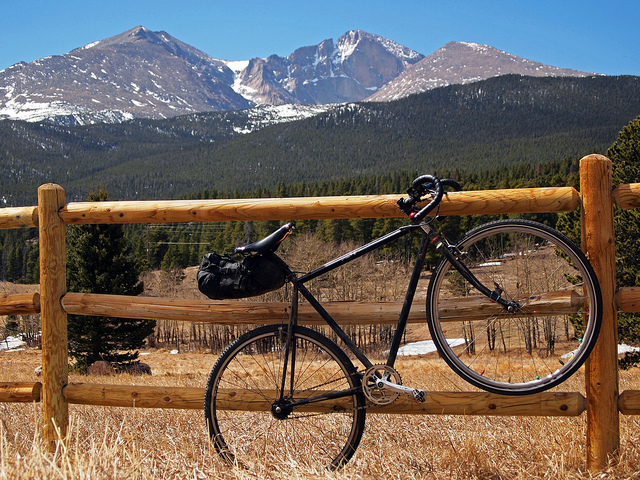
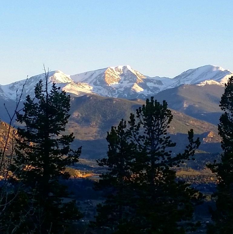
Longs Peak is THE absolute monarch of both Rocky Mountain National Park where it resides, as well as for all the Colorado 14ers. It makes a righteous goal to ride bikes to.
Complete Trail Network Map and GPX Download
[su_qrcode data=”https://justinsimoni.com/bikepacking14ers_gpx/Longs_Peak__Front_Range_14er_Bikepacking_Routes.gpx” size=”100″ color=”#000000″ background=”#ffffff” class=””]
This network of a dozen different vetted out routes from different starting points can help you design your own trip. Routes are described below.
Special Concerns
Longs Peak is surrounded by public land in the form of National Park and Wilderness, as well as land locked up in private property surrounding the nearby town of Estes Park, as well as in the Tahosa Valley to the south.
Access from the west is complicated by the incredible ridgeline of the Continental Divide, most of which is also in the Indian Peaks Wilderness. Scant National Forest public land is available to utilize for free, dispersed camping in the north, west, and south. The majority of self-powered adventures to Longs Peak are done as very long day trips from Boulder. But with careful planning, one can successfully plan a multi-day bikepacking trip that includes an ascent of the summit of Longs Peak.
Most access into Rocky Mountain National Park also requires paying the Park fee. A big exception is the East Longs Peak TH, making this a very popular trailhead for all trail users and the one I would suggest you use for your trip.
More Information
Trailheads
East Longs Peak Trailhead
East Longs Peak TH is located a mile off of HW 7, and makes for the most convenient and obvious trailhead for self-powered adventures. Most likely, this will be your transition point from cycling to hiking.
The most popular routes, including the Class 3 Keyhole Route and Loft Routes, as well as the technical Cables route can all be most easily access from this trailhead. Even if one isn’t feeling having such an audacious day, a trip up to Chasm Lake is worth the investment. The trailhead is also plowed and maintained in Winter, if you want to test your cold-weather meddle.
Although most access to Rocky Mountain National Park requires paying the Park fee, access via the East Longs Peak trailhead does not. You’ll even find a bike lockup area!
Camping in RMNP
Longs Peak Campground
A first-come, first-serve Park campsite is available a few hundred feet from the trailhead, but this campsite often fills up quickly during the summer seasons, so its best to temper expectations. More Information.
Other nearby Park campsites require a reservation permit ahead of time. Some sites to consider are Goblins Forest and The Boulderfield. More Information
National Forest Campsites
Dispersed Camping in National Forest
FDR 119, Meeker Park
National Forest Access can be found off HW 72, by heading east on CO 82 until FDR 119. After the National Forest Boundary, find a dispersed campsite off of the road.
Ski Road, Allenspark
Locate Ski Road in the town of Allenspark and ride it south until after the National Forest boundary. Seek out a good dispersed site.
Summit Route Suggestions
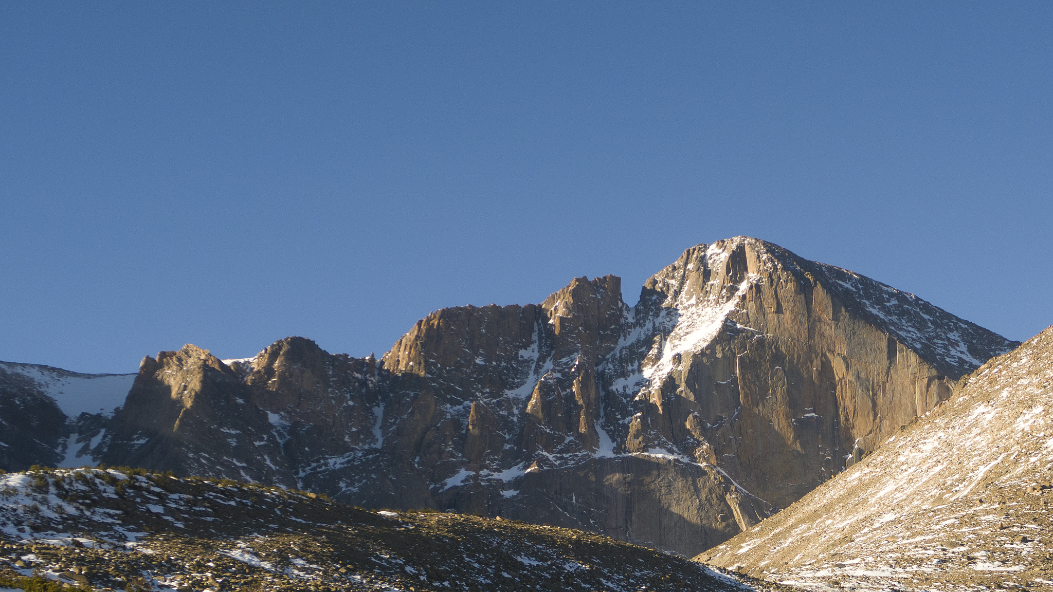
Longs Peak has dozens of routes to its summit, and the majority are accessed from the East Longs Peak Trailhead. Unless you’re hauling technical climbing gear, are familiar with the area, or have mountaineering experience, you’re most likely going to be most interested in the Keyhole, or Loft Routes.
Wild Basin Trailhead
Wild Basin Trailhead is also found right off of HW 7 just a few miles south from the East Longs Peak TH, and provides access to the south side of Longs Peak. This trailhead usually is manned during the summer season; other times the payment will need to be made on the honor system.
East Longs Peak TH and Wild Basin TH are so close, any routes that go to East Longs Peak TH can be easily modified to go to Wild Basin:
- East Longs Peak TH is off of HW 7, at mile marker 9.
- Wild Basin TH is off of HW 7 between mile marker 13 and 12.
Wild Basin gives the easiest access to Keplinger’s Couloir which can be used as a technical Winter route, or as a moderate Spring snow climb. Both itineraries are long, and most people who start merely at the trailhead after driving up anticipate either a very long day, or break up the climb into two days, camping (with permit) near Sandbeach Lake.
Camping
Campsites used for East Longs Peak TH also work well for Wild Basin. For camping within the Park, consider Sandeach Lake.
Summit Route Suggestions
This trailhead is used to access the Keplingers Couloir route. In summer, this route can be done without special snow climbing gear, but it’s a fairly long slog, and is best approached as a late spring snow climb on stable snow.
Glacier Gorge Junction Trailhead
Glacier Gorge Junction TH is an extremely popular trailhead off of Bear Lake Road inside the Park itself. Access to the trailhead is done via the east portal of the Park, and requires you to pay the Park entrance fee. Access by bike to the trailhead may be restricted during some parts of the year, so best to double-check access is allowed before planning your trip.
This trailhead is also a reasonable choice if you’re accessing Longs Peak from the west, which is rarely done by bike. You will most likely need to have a permit for camping within the Park sorted out before embarking on such an adventure, or be satisfied with a day trip up Glacier Gorge, which is absolutely worth the side trip, before resupplying in Estes Park.
Since Bear Lake Road gets very congested, it’s suggested you ride it as early in the morning as possible. Glacier Gorge Junction Trailhead gives you access to the Trough Direct route – one of the longest snow climbs in the Park, as well as some of the lesser known and rarely climbed west face technical climbs.
Camping
Camping within the Park is a realistic option, so long as you get a permit ahead of time. The most useful campsite for an assault on Longs Peak from this trail would be Glacier Gorge Campsite.
Summit Route Suggestions
Access to upper Longs Peak is usually done by a snow climb up the Loft Couloir, and proper snow gear would be required. You can also take the North Longs Peak trail to Granite Pass and access the Keyole Route from there.
Cycling Routes
From Estes Park
Estes Park is the closest town to the eastern and northern trailheads from Longs Peak and starting from here makes the shortest ride up to the closest trailheads. Glacier Gorge Junction TH is only ~12 miles from town; East Longs Peak TH is ~11 miles.
Getting There
From Denver, Westminster, Boulder, and Lyons, take the Bustang Estes Park bus:
LP1: Estes Park to East Longs Peak TH via HW 7
- Surface Type: Paved Road
- Mileage: 10.45 miles
- Elevation Gain: 2,258′
- Camping: No
The simplest route from Estes Park to the East Longs Peak TH. From Estes Park, follow HW 7 south to mile marker 9. Turn right on Longs Peak Road and take it to its terminus.
This is a reasonable route to ride to, then hike to the summit in the day, but don’t ignore the 2,000’+ elevation gain climbed to get to the trailhead.
LP2: Estes Park to East Longs Peak TH via Pierson Park/FDR 117
- Surface Type: Road/Gravel/4WD
- Mileage: 20.3 miles
- Elevation Gain: 3,912′
- Camping: Yes
A righteous back-way route and as wild as you can get between Estes Park and the East Longs Peak TH. This route can only completed realistically by bike or by foot, as an enormous mud slide off the east slopes of Twin Sisters has rendered the track impassable indefinitely to most passenger vehicles. Expect a bit of hike-a-biking in this section.
From Estes Park, travel east on HW 36. Turn right onto Fish Creek Rd for 2.8 miles and turn onto Little Valley Drive. The road will climb up switchbacks as it crosses into National Forest. Good camping options start about a half a mile from the last switchback and dispersed camping will continue to be available until Cabin Creek, ~14 miles later.
Continue on Little Valley Road as it continues to become rougher. After a few miles, you’ll reach the massive mudslide that has completely taken out the road. Cross the mudslide, find the track again, then continue.
After a short descent, you’ll reach FDR 119. Turn right on FDR 119 and take the road south. You’ll be on this track until crossing out of the National Forest boundary, where you’ll hit the road junction with CO 82, and the beginning of civilization.
This is a great route in of itself. For your summit bid, it makes sense to camp near the southern end of FDR 119, then get up early to complete the rest of the route in the early morning. Water is a little scarce on route. Although there may be a flowing stream in the enormous trench created by the mudslide, it’s suggested to camel up a the beginning of your ride.
LP3: Estes Park to Glacier Gorge Junction TH
This is a reasonable early morning ride through RMNP to get a full day into the Glacier Gorge area of the Park.
From Boulder + Lyons
Boulder is the closest city outside of Estes Park to the east trailheads of Rocky Mountain National Park. The majority of trips by bike that visit Longs Peak start here, if not because the active, outdoor culture Boulder cultivates such outings.
Lyons is a smaller town 14 miles north of the city of Boulder. It can also make a good starting point for a self-powered trip.
A local hard-person challenge is to complete the Longs Peak duathlon from the northern city limits of Boulder: ride to and summit Longs Peak, then ride back to your starting point. A long day indeed. For a more elite challenge, consider dreaming about The Longs Peak Triathlon: ride to the Longs Peak trailhead, then summit via climbing one of the technical alpine wall routes on the Diamond, usually via the Casual Route (5.10a), then ride back.
LP4: East Longs Peak TH via HW 36/HW 7 *Classic*
- Surface Type: Paved Road
- Mileage: 38 miles
- Elevation Gain: 5,650‘
- Camping: Yes
If there was a trade route to Longs Peak, this is it. Travel is mostly on good paved roads with ample shoulder. Although not the shortest route to Longs Peak from Boulder, it is most likely the swiftest. One can also cut ~14 miles one-way by starting in Lyons.
From the northern city limits of Boulder, ride north on HW 36 towards the town of Lyons. This stretch is incredibly popular with the local road cycling and triathlon cults. During the day, expect friendly company and questions about why you’re riding with lashed trail runners and ice axes to your frame. During the day, traffic can be heavy, but the shoulder is reasonable. Sub 24 hour trips that start before dawn will see more elk beside the road than vehicles traveling on it. If this type of highway riding is not agreeable, see the alternative below.
After ~14 miles, you’ll reach the town limits of Lyons. Take a left to enter town proper at the first stop light you reach. This is Main Street. Travel straight through town. Most services will be available to you including groceries, bike shops, and coffee. The first gas station on the south side of the road is usually open by 5:00am.
At the end of town, turn left on 5th Ave./HW 7 and get ready to climb for the next 15 miles. In of itself, this is an absolute classic Front Range hill climb, and the pitch is much more gentle than others in the immediate area. The shoulder is again reasonable for cycling, as is the vehicular speed limit. You’ll enter into National Forest, but camping is not allowed in the canyon (posted). This canyon is popular for picnicking by the St. Vrain, fishing, rock climbing, and other day uses.
After ~15 miles of almost continuous climbing, you’ll reach a road junction with HW 72, near the hamlet of Raymond.
This junction is where many different routes from the east and south meet, and the route directions below to the trailhead will be shared by all these routes.
Continue straight (don’t turn left) towards Allenspark on HW 72. You have 10 more miles to go to get to the trailhead. One-star camping is available right before this junction if you need a major break, but I would suggest continuing to the town of Allenspark, 4 miles away.
Pass the town of Allenspark. Limited services may be available, but good National Forest access is available on Ski Road, accessed by riding through town. This makes a good stopping point for either Wild Basin or the East Longs Peak THs.
At mile marker 9, turn left onto Longs Peak Road. The East Longs Peak TH will be found a mile up the road, at its terminus.
Alternatively at mile mark 9, continue past the East Longs Peak Road to reach Estes Park 10 miles further for resupply, access to the Glacier Gorge Junction TH, Trail Ridge/Old Fall River Road and points beyond.
HW 36 Alternative: East Plains
- Surface Type: Well-Maintained Gravel, Paved Road
- Mileage: 19.4 (to Lyons)
- Elevation Gain: 674‘
- Camping: no
If one is not in such a rush and would like to skip busy HW 36, travel a few miles to the east on quieter pastoral roads where one may spot bald eagles, horseback riding, and old homesteads. This route is also very popular with the local cycling culture, so you’ll almost definitely run into like-minded people.
This route is ~4.5 miles longer, but would be more a enjoyable route if you are riding in the day time, during a busy summer weekend, and/or are not in a rush to get to the trailhead.
LP5: East Longs Peak TH via James Canyon
- Surface Type: Paved Road/Gravel
- Mileage: 33.5
- Elevation Gain: 5,582′
- Camping: yes
This is quieter way to the East Longs Peak TH than through Lyons. Even though it’s shorter, don’t expect it to be faster. James Canyon features a very steep hill climb that ends in a gravel road that spans a few miles until you reach the HW 72. You will be on HW 72 for a longer spell, but the views west towards the Indian Peaks and RMNP are hard to beat.
From North Boulder, start off on Lee Hill Road going west. At the junction of Lee Hill and Olde Stage Road, take Olde Stage Road North. Once you reach a stop sign, take a left and head up Lefthand Canyon Dr. At the junction between Lefthand Canyon and James Canyon, turn right onto James Canyon. Take James Canyon all the way to HW 72. Expect a very steep climb. Turn right on HW 72 and follow it north. Near the hamlet of Raymond, you’ll hit the HW 72/HW 7 junction. Continue on HW 72 by turning left.
Continue by following the route directions for East Longs Peak TH via HW 36/HW 7 at the HW 72/HW 7 junction.
Variations
Boulder is awash with classic hill climbs right from town, onto HW 72. Most of these alternatives would make a great stand in for James Canyon, although none would be as short. Routes such as East Magnolia will take you to the town of Nederland, a good resupply point. Others, like taking the Switerland Trail, will provide you with the dirt riding you may seek. I don’t suggest utilizing Boulder Canyon, as the traffic on the road makes it a less than ideal choice.
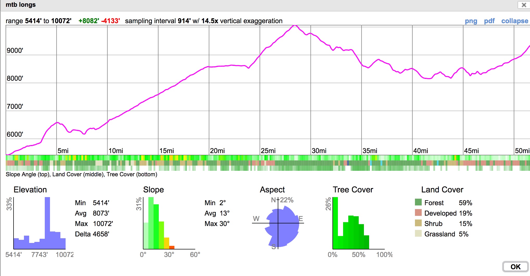
LP6: East Longs Peak TH via Heil Valley Ranch+ Johnny Park
- Surface Type: Paved Road/Singletrack/Moderate 4WD
- Mileage: 43.5
- Elevation Gain: 6,826′
- Camping: yes
This is your best off-pavement option to access Longs Peak from Boulder. We’ll be linking up different parks, trail systems, and 4WD roads in an attempt to avoid most of the pavement we can. Many different variations exist, depending on how much time you want to spend on the route, but I’ll be describing what I think is the best course.
From the North Boulder City limits, head up HW 36 for a few miles to Joder Ranch, and take a left to enter. Joder starts with a hill climb up a tame gravel road, then switches to easy singletrack at its apex. Exit Joder onto Olde Stage Road and take a right. At the stop sign, continue straight onto Lefthand Canyon Dr. and enjoy the downhill. Don’t miss the turn on the left into Heil Valley Ranch (signed).
After entering Heil Valley Ranch, take the Wapiti Trail north until the junction with Picture Rock, then take Picture Rock north. The trail will become much more smoother and flowy. Enjoy.
Picture Rock will end just outside of Lyons. Enter into Lyons by turning right on 5th Ave./HW 7 going north. If you need to resupply, here’s your chance – a small market is located right at Main Street to your right. When you’re good to go, continue out of town on HW 36, for a ~10 mile hill climb. This will be the least enjoyable part of the route, but no dirt alternatives exist.
Once your tarmac time is up and right after the hamlet of Pinewood, turn left onto CO 47/Big Elk Road and take it southwest to the Coulson Gulch TH. This is the start of the Johnny Park 4WD track. You’ll be riding this west to its terminus at CO 82, around 6 miles from the TH.
CO 82 marks the start back into civilization. Take CO 82 northwest. After two miles, you’ll reach HW 7. Turn right on HW 7 and take it north towards the East Longs Peak TH, about two miles away (mile marker 9). Turn left onto Longs Peak Road and take it to its terminus.
If you’re planning to camp before your summit bid in the morning, turn right onto FDR 119 right before getting on CO 82. Ride into the National Forest boundary and find a good dispersed campsite.
Variations
To avoid some of the beginning highway riding on HW 36, turn right on Broadway Street just a few hundred meters at the HW 36/Broadway junction found at the northern city limits of Boulder, to the Foothills TH.
Take the Boulder Valley Ranch trail system in a circuitous direction, eventually leading to Neva Access Road going north, then finally back to HW 36. Joder Ranch can be found just up the road on the left. Rejoin the main route.
To avoid Heil Valley Ranch completely, take HW 36 north all the way to Lyons. Pick up the main route at the west end of town by taking Main Street west. Another option if you are starting from Boulder is to take the bus to Lyons in the morning!
To skip Johnny Park, take HW 7 southwest, rather than HW 36 northwest at the west end of Lyons. Taking HW 36 northwest, you’ll end up in Estes Park, 11 miles and 2200’+ below the E Longs Peak TH.
LP7: Boulder to Estes Park via HW 36
- Surface Type: Paved Road
- Mileage: 32.08 (to Estes Park)
- Elevation Gain: 3,913′
- Camping: yes
A classic road ride, it isn’t without its concerns. The direct route to Estes Park from Lyons can get congested with summertime traffic to Estes, and the shoulder is quiet narrow in places. Even for bikepacks that end at Glacier Gorge Junction TH, I would suggest taking any other route that finds you to the south of Estes Park, then drop down. Rarely do people take sub 24 trips to Longs Peak using Glacier Gorge Junction TH from Boulder.
Take any of the routes you would like from Boulder to Lyons. I suggest simply HW 36. From the west side of Lyons, turn right to continue onto HW 36 and take it northwest until you reach Estes Park. Prepare for almost continuous climbing until right before town limits.
Camping
Dispersed camping on route is limited, but find a spot on Pole Hill Road (4WD), right before the descent into town. More Information.
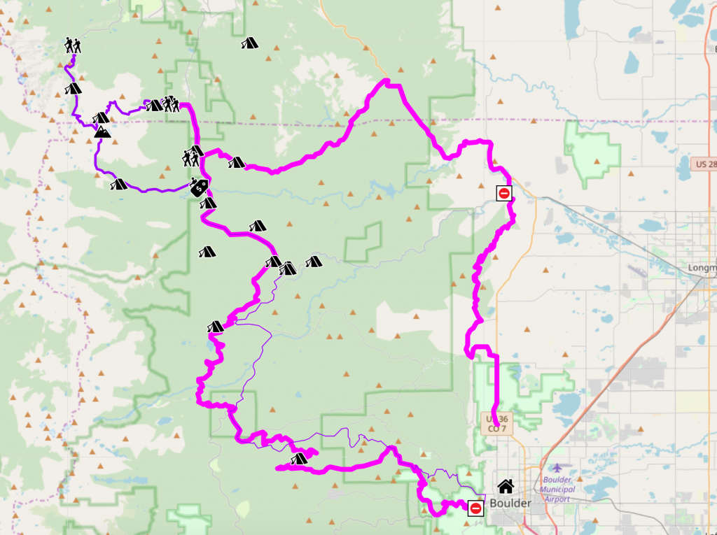
LP13: East Longs Peak TH via Betasso/Swiss Trail/Sourdough
- Surface Type: Paved Road/Gravel/4WD/Singletrack
- Mileage: 51.8
- Elevation Gain: 8,082′
- Camping: Yes
This is your other best off-pavement option to access Longs Peak from Boulder. Combing this route with LP6: East Longs Peak TH via Heil Valley Ranch+ Johnny Park makes a righteous bikepacking route, even if you don’t even get on the mountain. I would suggest this a the route to take up, and do LP6 in reverse as what’s narrated here.
The stats are quite impressive when coupled with the surface types, so I’ll be explaining some easier section detours to bailout, just to make sure you make it to your destination in time.
Detour #1
Road/Trail Closures: Boulder Canyon
Unfortunately, Boulder Canyon is currently closed to bicycles wanting to climb to Betasso, so for the time being you’ll need to detour the start by taking Sunshine Canyon/Gold Hill Road (paved) west to Poorman Dr. (gravel), then to Four Mile Canyon (paved).
This route starts at Eben G. Fine Park. Take the multiuse path that parallels Boulder Canyon Dr. west to its terminus. Pop out, and head onto the Boulder Canyon Dr. west until the trailhead for Betasso Link Trail, which will allow you access Betasso Preserve proper. Betasso Link starts out very steep, so expect some hike-a-bike with a loaded down bike.
Cross over Betasso Road and continue riding north into the Betasso Preserve proper to the Four Mile Canyon TH via first the Canyon Loop Trail, then Benjamin Loop Trail, and finally linking up to the Fourmile Link Trail. The two link trails are directional, and change directions every few weeks.
This trail system is uncharacteristically smooth/flowy for a Front Range trail. Enjoy!
Detour #2
Betasso is closed to bikes on Wednesdays and Saturdays. At the end of the multiuse path, instead of heading west on Boulder Canyon Dr., head north on Fourmile Canyon Dr. (paved). Rejoin the main route at the townsite of Salina.
Once through Betasso, head west/northwest on Four Mile Canyon Dr. to the townsite of Salina. Continue on Four Mile Canyon Dr. to its terminus, where you’ll run into the Switzerland Trail, an old railroad bed that’s been turned into a mild 4WD track.
Take the Switzerland Trail northeast as it switchbacks up north towards Gold Hill Road. You’ll enter into National Forest – some of the closest NF access to the city of Boulder, and some camping opportunities will present themselves. Keep riding and cross Gold Hill Road.
Detour #2
Rather than taking the first part of the Switzerland Trail, at Salina, take Gold Run Road (gravel) northwest to the small town of Gold Hill. A mercantile can be found there. Once in Gold Hill, to the Gold Hill Road (gravel) west, and rejoin the route at the Switzerland Trail junction.
Continue on the Switzerland trail northeest towards Lefthand Canyon Dr. At the end of the Swiss Trail, be ready for the trail itself to peter out to singletrack, then disappear completely. Look to your left/south for a slope to take on stout but brief hike-a-bike climb out from old rail bed and onto Sawmill Road (gravel). Descend Sawmill Road west to Lefthand Canyon. Take Lefthand Canyon to the town of Ward. Another mercantile is found here.
Detour #3
To skip the second part of the Switzerland Trail, at the junction with Gold Hill Road and the Switzerland Trail, take Gold Hill Road (gravel) west. Turn right onto Sawmill Road, the left onto Lefthand Canyon Dr. towards Ward and rejoin the main route.
Climb out of Ward to the end of Lefthand Canyon and exit onto HW 72. Stay on HW 72 for just a few hundred feet until Brainard Lake Road. Turn left on Brainard Lake Road (paved). Take this road west until the first (Winter) parking lot. Find the South Sourdough Trail (singletrack) and take it north. Sourdough is blue/black in difficulty, so expect more of a challenge than both Betasso or the Swiss Trail. Sourdough will end near Peaceful Valley – you can continue on CR 105 (4WD) to avoid the highway for a little while longer and enter onto HW 36 on Bunce School Road.
Detour #4
Sourdough will be the most challenging single trail on this route. To avoid it fully, continue on HW 36 (paved) north after Ward. Rejoin the main route at Bunce School Road.
Head north on HW 36 and take the road all the way to Mile Marker 9. Turn left on Longs Peak Road and ride it to its terminus and the East Longs Peak TH.
Variations
If one takes all the detours, you’re left with a fairly good, mostly paved/some gravel route to the TH. To tighten up the route a bit, start at Sunshine Canyon/Gold Hill Rd. and just continue on Gold Hill Rd. west until Sawmill Rd., skipping the descent down Poorman, and reascend back up to Gold Hill via Gold Run.
Fort Collins
LP8: Fort Collins to Estes Park via HW 34
- Surface Type: Paved Road
- Mileage: 40.59 (to Estes Park)
- Elevation Gain: 4,110′
- Camping: ???
Fort Collins is a city located northeast of Estes Park. HW 34 gives fairly direct access to Estes Park through Big Thompson Canyon.
From Fort Collins, travel south until reaching HW 34. The route I’ve mapped out takes interesting back roads past Horsetooth Resevoir, and the hamlet of Masonville. Once on HW 34, take it west. The start of the canyon is pretty narrow and although you will have a shoulder, the right boundary will be a Jersey barrier, with cliffs rising all above you. Once through the mouth of the canyon, things open up.
Idaho Springs
Idaho Springs is closest to Mt. Evans, and not all that far away from Grays and Torreys, all of which are in the Front Range. Riding to Longs Peak from Idaho Springs makes sense when linking up multiple 14ers, say: all the Front Range 14ers.
LP9: Idaho Springs to the East Longs Peak TH via Virginia Canyon/Apex/Mammoth Gulch/East Portal
- Surface Type: Paved Road/Gravel/4WD
- Mileage: 62.1 mi
- Elevation Gain: 8,714′
- Camping: Yes
This is the back roads route, and attempts to miss much of the highway north of Idaho Springs. Prepare for excellent views of the James Peak Wilderness just to the west on Mammoth Gulch, as well as glimpses of Longs Peak from a distance.
From downtown Idaho Springs, locate Virginia Canyon on the east end of downtown. Turn left on Virginia Canyon and ride north. Find the first switchback to your right and take it. Straight ahead is Two Brothers, which the route to the right attempts to avoid, as Two Brothers is exceptionally steep. Virginia Canyon will wander across the Central City Parkway, passing old mine sites on its way.
Carefully cross this highway, then continue on Virginia Canyon, which will rocket into town. Enter Central City and take a left onto Eureka Street. Eureka will turn into Upper Apex Road. Continue on Upper Apex as it climbs northwest. Great gravel riding is found here.
Turn left on Country Road 4-N and head west climbing steeply past houses with cluttered front yards. If you see the landowner, make an offer on any of the refuse that catches your eye. After 2 miles, turn right and head north at a junction. Continuing straight will take you to Kingston Peak Road, where good dispersed camping can be found as well as James Peak and the boundary for the James Peak Wilderness.
The track will become rougher here, and maybe too much for a gravel bike. This is a popular summer camping area and dispersed camping options can easily be found. CR 4-N/Mammoth Gulch will end at East Portal Road. Turn right and head east on East Portal to HW 119 and the town of Rollinsville. A small market is found in town, but it’s better to wait until Nederland to resupply. Turn right on HW 119 and head north towards Nederland. All services are available in Nederland.
At the north end of town, ride the roundabout, and turn west onto HW 72. Take HW 72 north until you reach the HW 72/HW 7.
Continue by following the route directions for East Longs Peak TH via HW 36/HW 7.
Variations
1: (This route is allows you to avoid Central City completely and adds more riding on dirt, but access is uncomfortably near private property for me to include it in the main route, until I’ve gotten clarification on access issues.)
Near the high point of Virginia Canyon, north of the switchbacks, turn left on Alps Hill Road/Bald Mountain Drive and carefully locate the public 4WD track on your right. The track will become steeper and rougher at this point. At the road junction, turn onto Kings Flat Road. Rejoin the route at the Foresters Cemetery.
2: From Idaho Springs, take the Central City Parkway found just east of town to Central City, in lieu of Virginia Canyon. “The Million Dollar Highway” has a wide shoulder and is a classic road climb, although it’s ending into Central City is a little anti-climatic.
3: From Central City, take Gregory Street out of town to Black Hawk and reach HW 119. Black Hawk has actually banned riding bicycles in town on Gregory Street (the only town in the state to do so), so make sure to turn right on Bobtail Street for a circuitous detour to HW 119. Turn left on HW 119 and go west, then northwest. Turn right on Apex Valley road to regain the main route, or continue on 119 to reach Rollinsville and rejoin the route there.
Taking Central City Parkway to HW 119 will avoid all gravel/4WD.
From Summit County
Idaho Springs is closest to Mt. Evans, and not all that far away from Grays and Torreys, all of which are in the Front Range. Riding to Longs Peak from Idaho Springs makes sense when linking up multiple 14ers, say: all the Front Range 14ers.
Summit County is closest to Quandary Peak, with the Democrat group just over Hooiser Pass, all of which are in the Mosquito/Tenmile Range. Riding to Longs Peak from Summit County would be quite peculiar, but these routes are too good not to include.
LP10: via Rollins Pass
- Surface Type: Paved Road/Gravel/4WD
- Mileage: 119.34
- Elevation Gain: 9,965
- Camping: Yes
A most excellent bikepack route on its own, riding over 11,000’+ Rollins Pass and across the Continental Divide should be a right of passage for the nascent Colorado bikepacker. This route starts off on the Great Divide Mountain Bike Route for a short spell, until taking you to Winter Park, then up and over Rollins Pass, and afterwards through the town of Nederland. The route rejoins many of the other routes once at the HW 7/72 junction near Raymond.
This route starts on the Great Divide Mountain Bike Route. From Silverthorne, take HW 9 north until Ute Pass Road. Turn right on Ute Pass Road. The climb up will lead you to the Henderson Mine, so it’s very discouraged to pick up surface water or camp.
Turn right on CR 32 east. This is a good gravel road with lots of dispersed camping opportunities. Continue on CR 32 at the CR 32/CR 325. CR 325 will take you to the Beyers Peak Wilderness, which is a great side trip.
You’ll reach the CR 32/CR 50 junction. Take CR 50 east. At the CR 50/CR 73 junction, take CR 32 northeast into Fraser. Turn right on Main Street HW 40 southeast through Winter Park. Turn left on CR 80 to being your climb up Rollins Pass. National Forest access will start, and an abundance of dispersed camping opportunities will be found. Ride up and over Rollins Pass. The 4WD track on the east side of Rollins Pass will be much rockier than the west.
Rollins Pass will end at East Portal Road. Take East Portal East to HW 119/Rollinsville and turn left on HW 119. Follow HW 119 to Nederland as described in, Idaho Springs to the East Longs Peak TH via Virginia Canyon/Apex/Mammoth Gulch/East Portal.
LP11: via Trail Ridge Road
- Surface Type: Paved Road/Gravel
- Mileage: 113.46 (to Estes Park)
- Elevation Gain: 7,639′
- Camping: Yes
Riding up and over the Continental Divide through Rocky Mountain National Park via Trail Ridge Road is classic road ride in of itself. Double-check on the road status, as Trail Ridge Road often closes for bad weather. You’ll also be required to pay the Park fee before entering RMNP. It’s suggested to get an early start up Trail Ridge Road, as the road gets very congested on summer days with motor vehicle visitor traffic.
The route starts the same as via Rollins Pass, but continue straight on the GDMBR at the HW 9 (Now CR 3)/CR 32 junction north. This junction is your best bet for dispersed camping for a while.
Continue on CR 3 until you reach HW 40 and take HW 40 east. Your time riding gravel is over. Just outside of Granby, turn left to continue on HW 34 to Grand Lake, just outside of the Park Boundaries. Pay your Park fee at the gate, and continue up and over Trail Ridge Road. This is an excellent road ride. Continue down Trail Ridge Road to Estes Park, or make a side trip to Glacier Gorge Junction TH.
Inspiration
Work in Progress
Bikepacking to the Colorado 14ers is currently being written and published publicly. Get news and updates by joining the Facebook group, Follow us on Instagram, join our subreddit, and mailing list.
You can support its development by purchasing items through the affiliate links on this site: check out the gear reviews, as well as the items below: