Like this? Follow me:
![]() If you’re enjoying this content, considering joining my Patreon to support future work.
If you’re enjoying this content, considering joining my Patreon to support future work.
The Colorado Trail is an awesome thru-hike route! But I noticed while hiking the CT, that much of the time that the best parts of an area you hike through just aren’t really showcased. The trail just weaves itself along a contour line below treeline, and you miss out on seeing most of the high country just outside your grasp.
Are you an advanced hiker?
If so, spice up your thru-hike by summiting a 14er or two (or all of them!) you can find right off the main trail! Below, I’ll describe all the 14er routes I’ve taken off the Colorado Trail, and some high 13er peaks that are also easily accessible. Most of the routes of the CT are in the Sawatch Range, between Leadville and just outside Salida. One is located in the San Juans outside of Creede, CO (San Luis).
For most of these routes, I would suggest dropping your main packs, and taking only what you realistically need from the out-and-back summit bid (hang your food, etc – of course). I describe the route mileage as one way, rather than RT, unless otherwise noted.
For some of these peaks, I do suggest an alternative loop which will ascend one route, and descend another, if you don’t mind missing a small portion of the Colorado Trail. For those options, bring everything, but realize that this makes the hike to the summit much harder. Make sure to time your hikes to miss the seasonal monsoon/thunderstorm weather (start early), and be mindful you’ve brought enough food for these CT alts. – they’ll take longer than the main trail.
All these routes are found on this CalTopo map (so bookmark it!), which can also be found embedded, below:
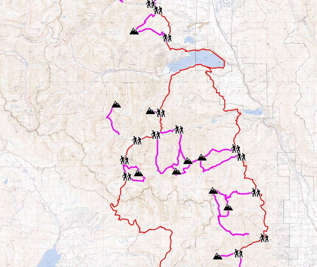
Unless I’ve noted, these are all routes I’ve done personally, so I can vouch for them. Have a suggestion or found a problem? Please, leave a comment, or contact me directly. This guide couldn’t have been done without the original CalTopo map found here, and the many route resources found at 14ers.com.
Using the CalTopo Maps and Descriptions
- The Colorado Trail is marked in red
- The deviations from the route, up to the summits of these peaks is marked in orange.
- Clicking on any of these map images will open up the image in a new window/tab in a larger resolution.
- Route descriptions will include coordinates of the junction off the Colorado Trail, Clicking the coordinate (example: 37.8477, -107.4613) will bring you to the CalTopo map, with that point centered.
Sawatch
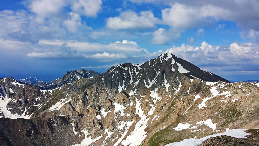
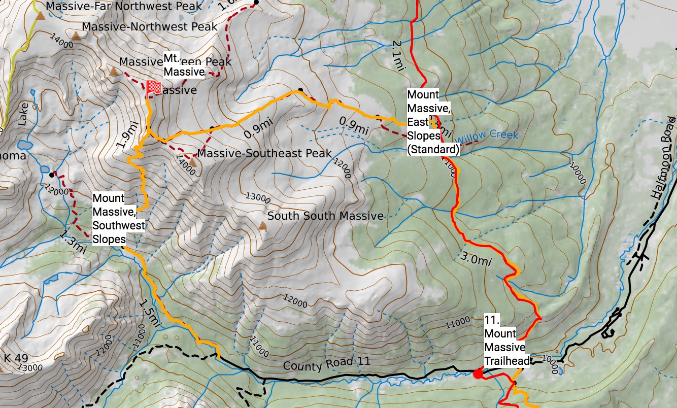
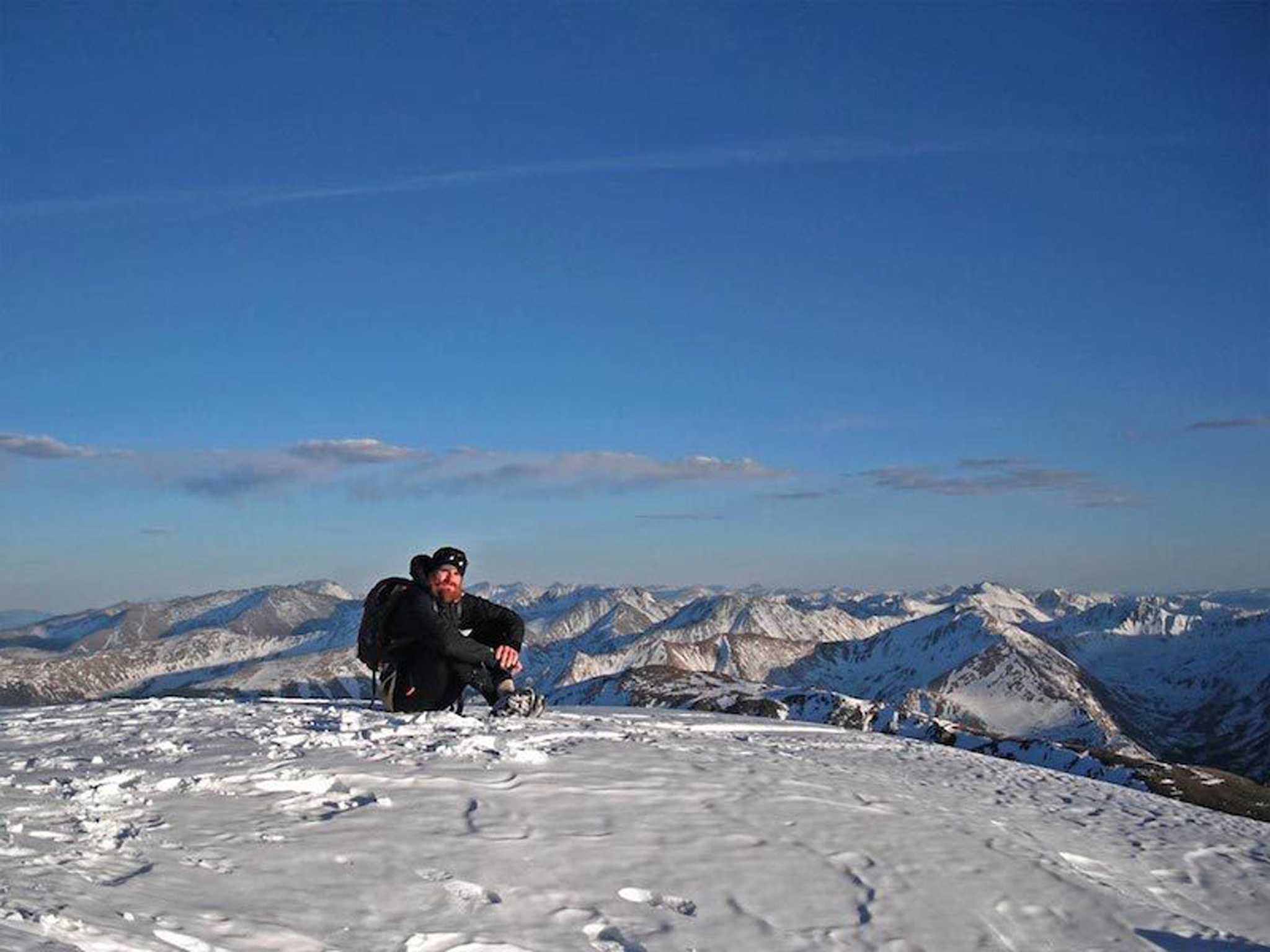
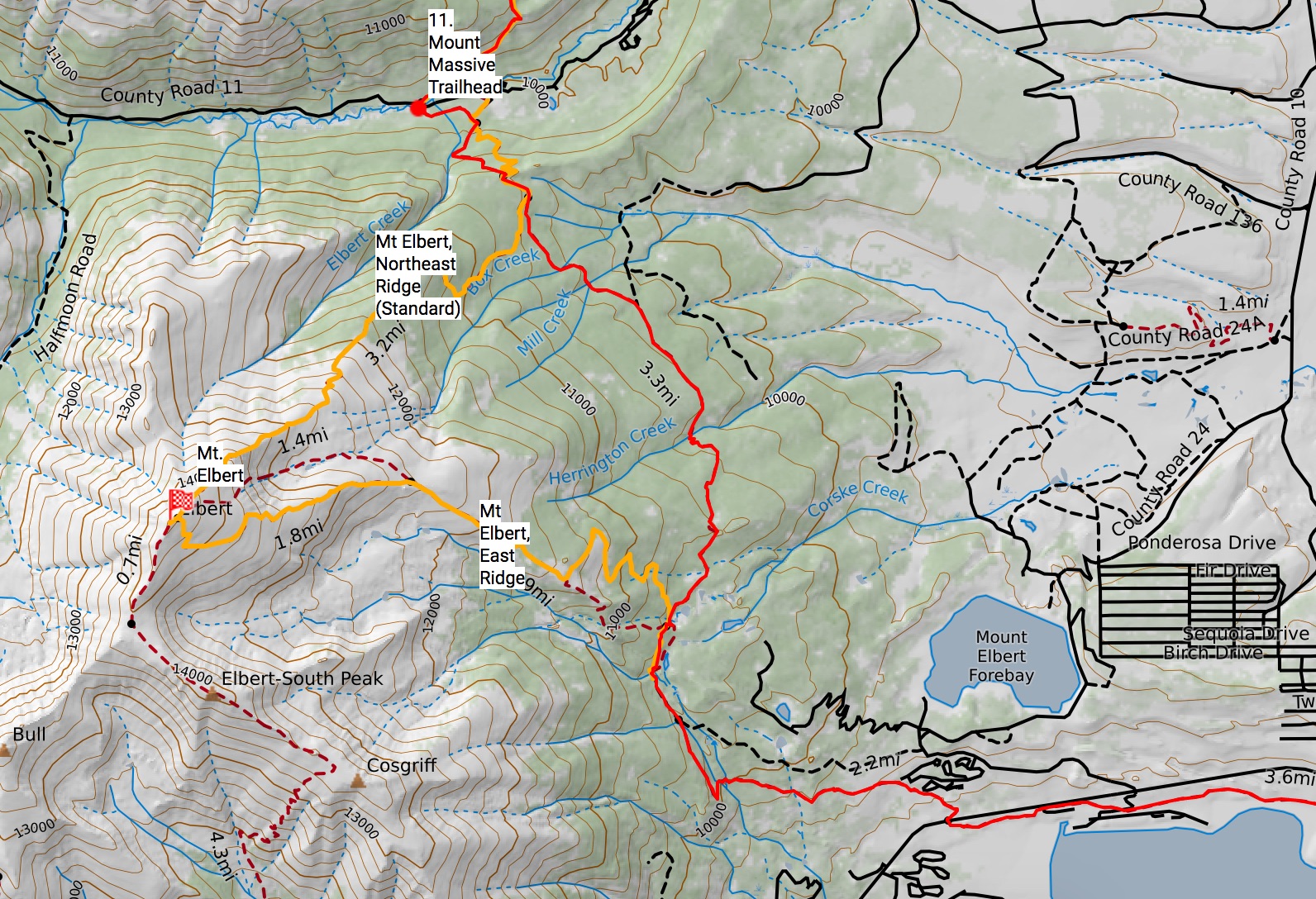
Mount Massive
The East Slopes route for Mount Massive is found on Segment 10 of the CT, right around Willow Creek (39.1807, -106.4252). Trail junction is signed. From the junction, it’s 3.65 miles on a Class 1 trail to the summit.
Alternatively, turn off the CT at the Mount Massive Trailhead (end of Segment 10), and head west on Halfmoon Road/CR11 to the Southwest Slopes route (39.1513, -106.4196). Trailhead is 2.59 mi from the CT. From the Mount Massive Trailhead/end of Segment 10, it’s 6.17 miles to the summit on a Class 1 Trail.
If you’re on MTB, you can ride to the Southwest Slopes TH, and leave the bike there. Mount Massive itself is in Wilderness, so no MTB’s on the trail itself.
If you don’t mind missing the last part of Segment 10, you can potentially go up the East Slopes Route, and down the Southwest Slopes Route, rejoining the CT at the end of Segment 10.
Mount Elbert
The Northeast Ridge route for Mt. Elbert is found on Segment 11 of the CT, just about a mile from the start of this segment (39.1440, -106.4080). Junction is signed. From this junction, it’s 3.3 miles to the summit on a Class 1 trail. Mt. Elbert is mostly in BLM, so MTB’s are allowed!
The trail is not well designing for riding, though – it’s more of a “did it for bragging rights”, rather than a destination trail (especially loaded with bikepacking bags). Still, it’s reasonable to ride a little ways past the trail junction, before getting off the bike.
The East Ridge route for Mt. Elbert is also found on Segment 11 of the CT, ~4.43 miles from the start of Segment 11 and much closer to the town of Twin Lakes (39.1102, -106.3935). From the junction, it’s 3.5 miles to the summit on a Class 1 trail.
If you don’t mind missing part of Segment 11, you can potentially go up the Northeast Ridge route, and down the East Ridge Route, rejoining the CT right before Twin Lakes.
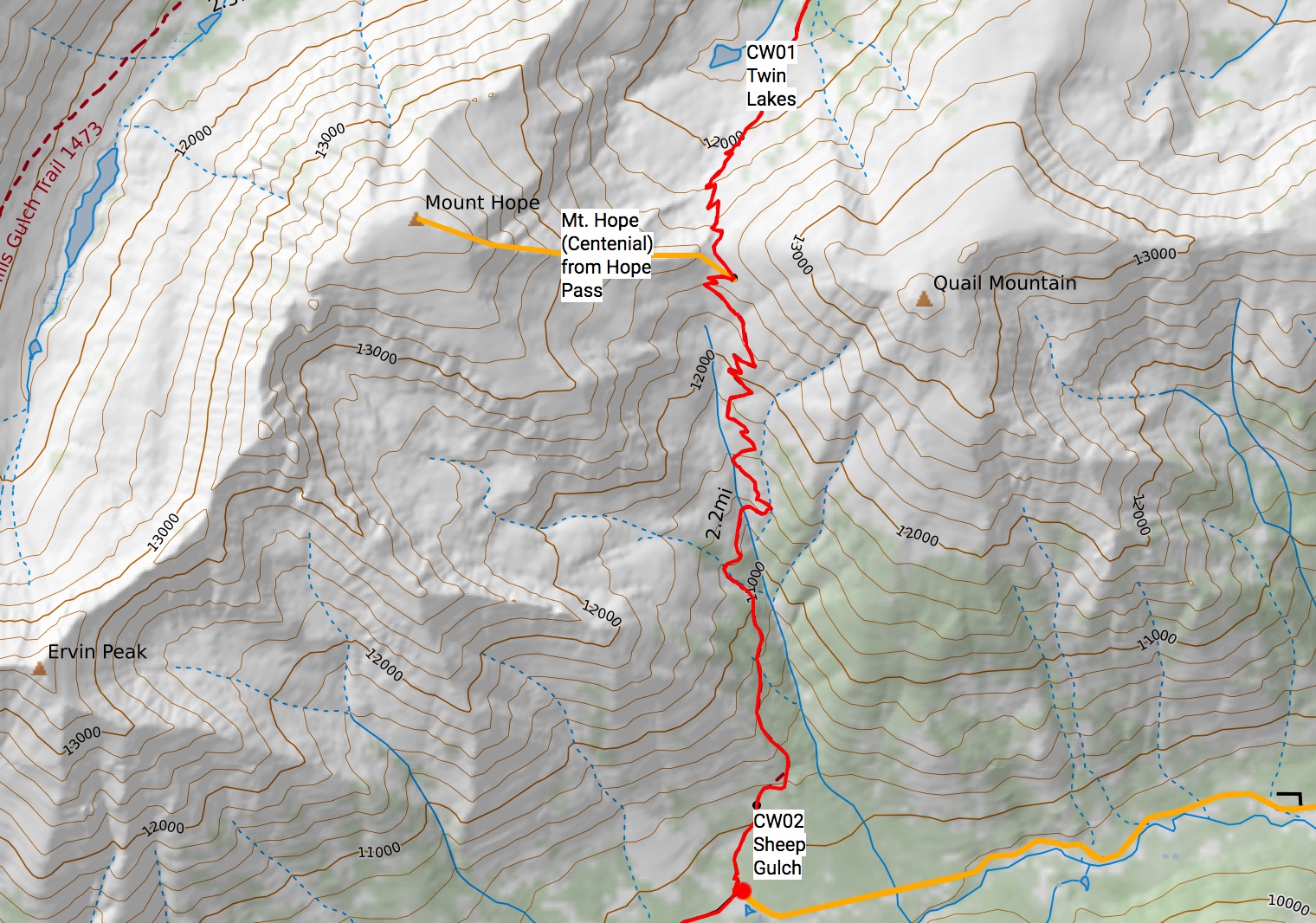
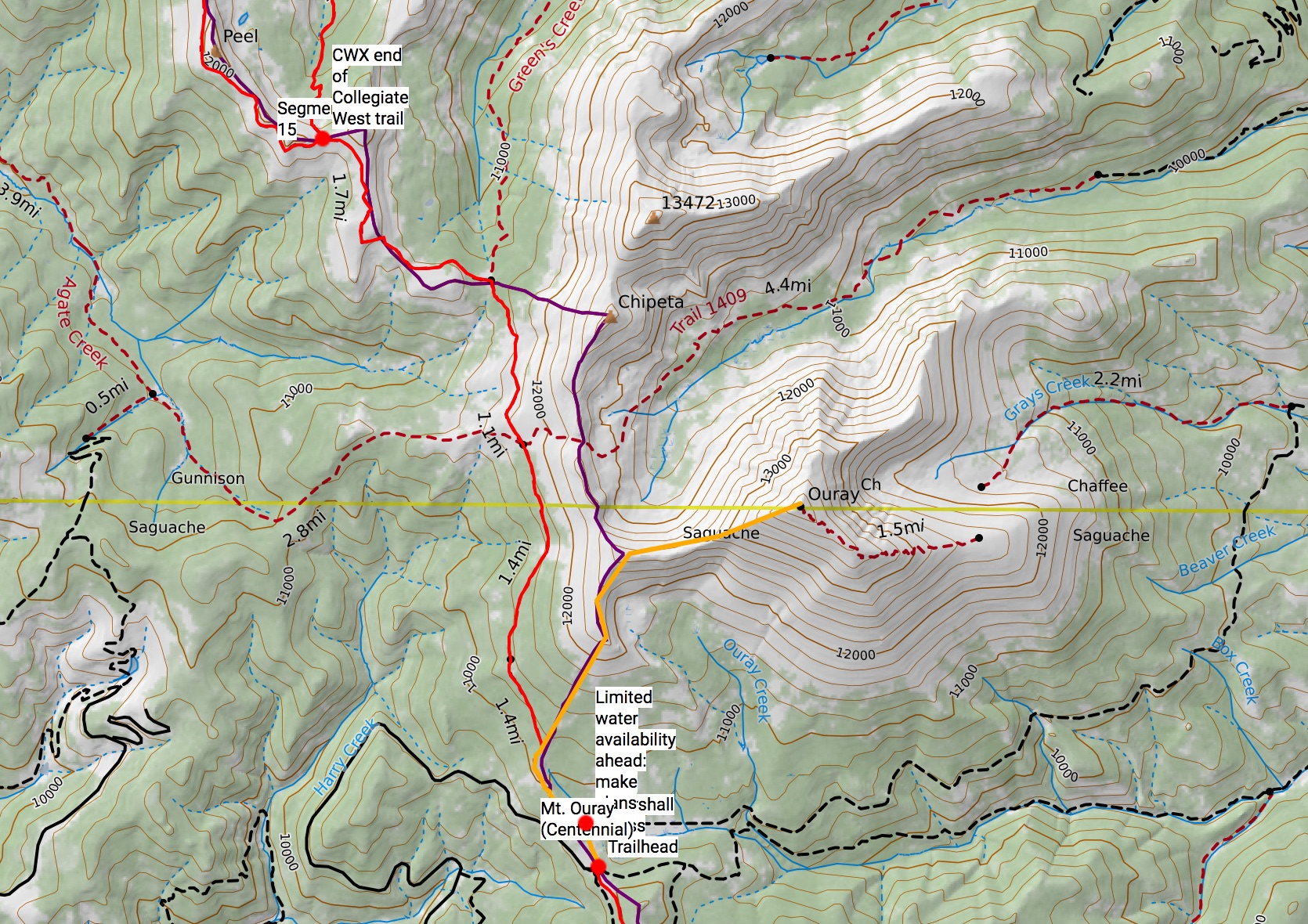
CT Collegiate West Variation
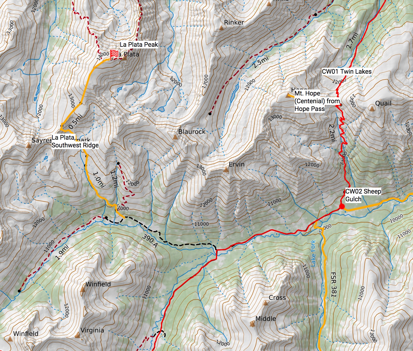
Mt. Hope
A Centennial (but not a 14er), Mount Hope is less than a mile west from Hope Pass on a mostly trail less Class 2 route (39.0187, -106.4041). Head west, taking the path of least resistance.
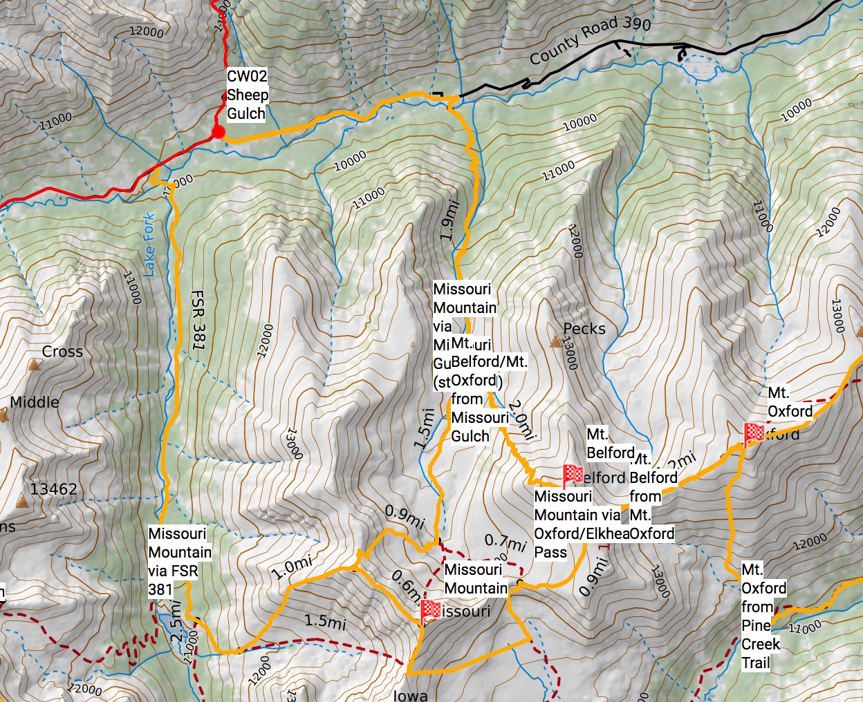
Missouri Mountain/Mt. Oxford/Mt. Belford via Missouri Gulch TH
These three mountains can all be accessed by the Missouri Gulch Trailhead (38.9982, -106.3748) This trailhead is 1.75 miles east of the Sheep Gulch trailhead on Chaffee County 390. Follow the standard routes for each of these mountains (Missouri Mountain, Northwest Ridge, Belford, Northwest Ridge + Oxford) From Sheep Gulch, the summit of Missouri is 6.82 miles; Belford is 5.6 miles; Oxford is a mile past Mt. Belford (link them up!)
All three mountains can be linked together from the Missouri Gulch Trailhead, by going up and over Elkhead Pass. From the Missouri Gulch TH, it’s over 14 miles round trip (a long day).
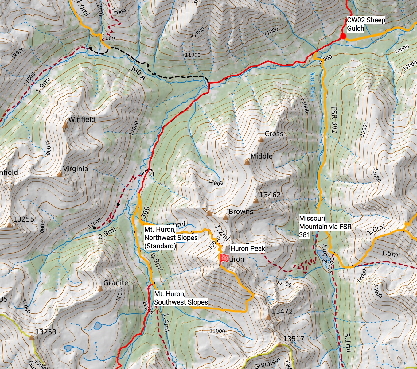
Missouri Mountain via FSR 381/Clohesy Lake
An alternative route up Missouri Mountain is to go South up the 4WD FSR 381 to Clohesy Lake, then take the trail east up Missouri (38.9918, -106.4113). FSR 381 is about a half a mile west on Chaffee County 390. The summit is 6 miles from Sheep Gulch on mostly Class 1 trails. The last bit is Class 2.
La Plata Peak
La Plata peak isn’t really found very near the CT, but it’s not so far away I feel I shouldn’t include it.
From Winfield (38.9850, -106.4412), it’s 1.79 miles on a 4WD trail to the trailhead, and then 3.5 miles to the summit on a Class 2 trail (5.29 miles, one-way total). Follow the Southwest Ridge route for La Plata Peak.
Mt. Huron
The Northwest Slopes route for Mt. Huron is found on the CW02 segment of the CT, 4.5 miles from the Sheep Gulch TH (38.9608, -106.4608). The junction is marked and the trail is very popular. It’s 2.87 miles from the junction, to the summit on a Class 1 trail. This is one of the easiest 14ers to hike.
Alternatively, the Southwest Slopes route for Mt. Huron is found about a mile further down the trail (38.9414, -106.4568). It’s a much more rougher trail (unmarked), so prepare for some route finding, deadfall, bushwhacking, and lots of off trail talus hoping and ridge walking.
If you don’t mind missing part of the Segment CW02, you may ascend the Northwest Slopes, and descend the Southwest Slopes route.
Main Route
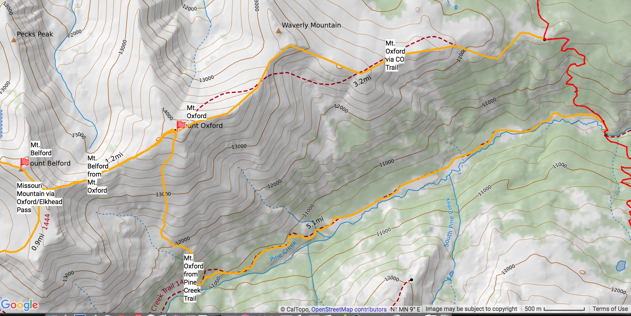
Mt. Oxford/Belford
Before dropping into the Pine Creek Drainage on Segment 12 of the CT, you can follow a ridgeline west over Waverly Mountain, then to Mt. Oxford, and then finally to Mt. Belford (38.9749, -106.2858). It’s 3.29 miles to Mt. Oxford, and about a mile more to Mt. Belford. This is a pretty non-standard route, and one of the few routes on this list that I haven’t done myself (so my beta may be flaky, apologies).
Alternatively, you can take the Pine Creek Trail west at the junction with the CT, and access Mt. Oxford via an avalanche path from the south (38.9652, -106.2773). This is part of the Nolans Route, so expect some major bushwhacking, once off the well-maintained Pine Creek Trail – I wouldn’t categorize this as a backpacking route once off Pine Creek Trail – it’s difficult terrain.
From the junction, it’s 5.68 miles to the summit of Mt. Oxford. This is also a non-standard, and rarely used route up Mt. Oxford. It shouldn’t exceed Class 2+. Great camping on Pine Creek.
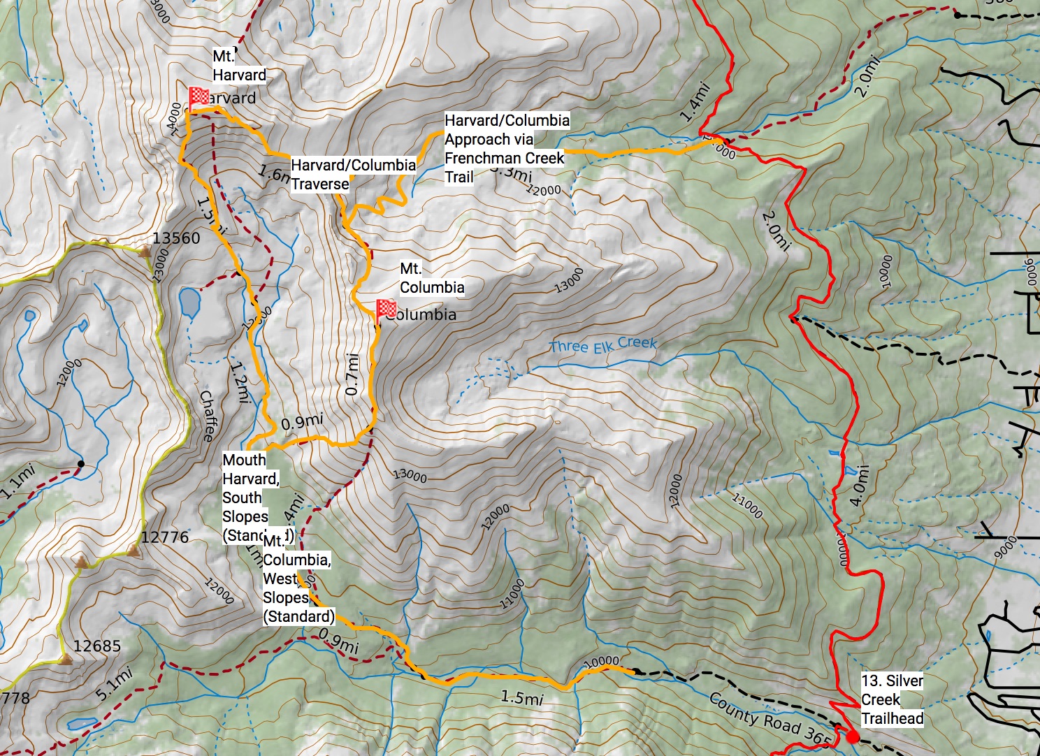
Mt. Harvard/Mt. Columbia
The shortest way to access Harvard/Columbia is on the French Creek Trail junction, off of Segment 12 of the CT (38.9214, -106.2546). This is not as widely used for day hikers, as it’s easier to access both these peaks from the N. Cottonwood Creek TH (parking lot there). The N. Cottonwood Creek TH is < mile west from the CO trail (at Silver Creek TH), so it’s viable for this guide to, but first, French Creek:
From the junction with the CT (38.9214, -106.2546), take the French Creek Trail west. It’s 3.3 miles until you reach a point partway between the Harvard/Columbia traverse route. You can then go Southeast from this point to summit Columbia (1.6 miles), or Northwest to summit Harvard (< mile) (see Caltopo map for specific route).
The standard way to access Harvard and Columbia is from the N. Cottonwood Creek TH (38.8657, -106.2412), which is less than a mile west of the Silver Creek TH, at the end of Segment 12 of the CT. Walk west up the road (or hitch it).
Follow the South Slopes route for Mt. Harvard (7 miles to the summit from N. Cottonwood), or the West Slopes for Mt. Columbia (6.5 miles from N. Cottonwood) Routes. One can do a traverse of the two summits, as well (15 miles RT from N. Cottonwood).
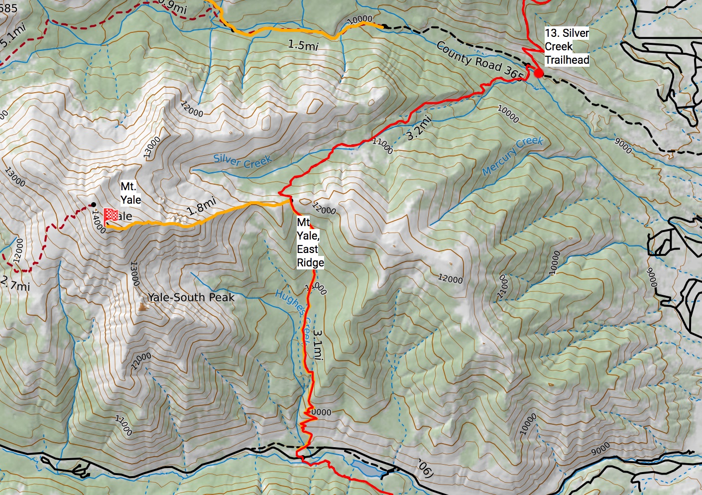
Mt Yale
Mt. Yales’s East Ridge Route is right off the Ct, on Segment 13 and is 3.1 Miles from the start of the segment (38.8472, -106.2818) . Head west from the highpoint (unmarked), following the obvious ridgeline. Fun Class 2. 1.85 miles to the summit from the trail junction.
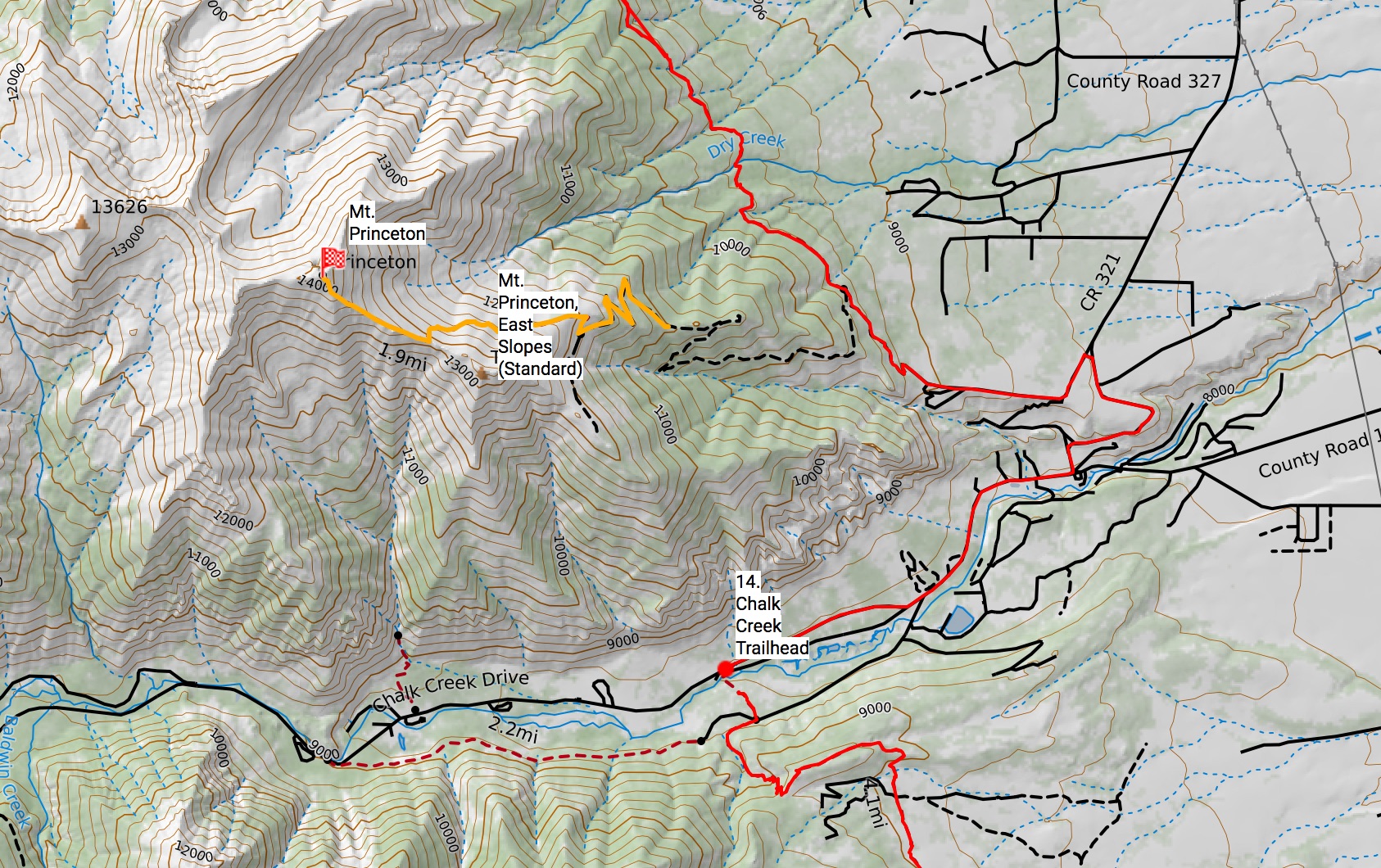
Mt. Princeton
Mt. Princeton’s East Slopes standard route starts right off the Colorado Trail, uphill and North of the Mt. Princeton Hot Springs on Segment 13 (38.7476, -106.1873). Follow CR 322 uphill and south, following switchbacks until an obvious trail junction. From the CT trail junction with CR322, it’s 5.6 miles to the summit. This isn’t a much-lauded route.
Segment 13 is open to MTB, and you can “easily” ride CR322 all the way up past the radio towers, to the obvious trail junction.
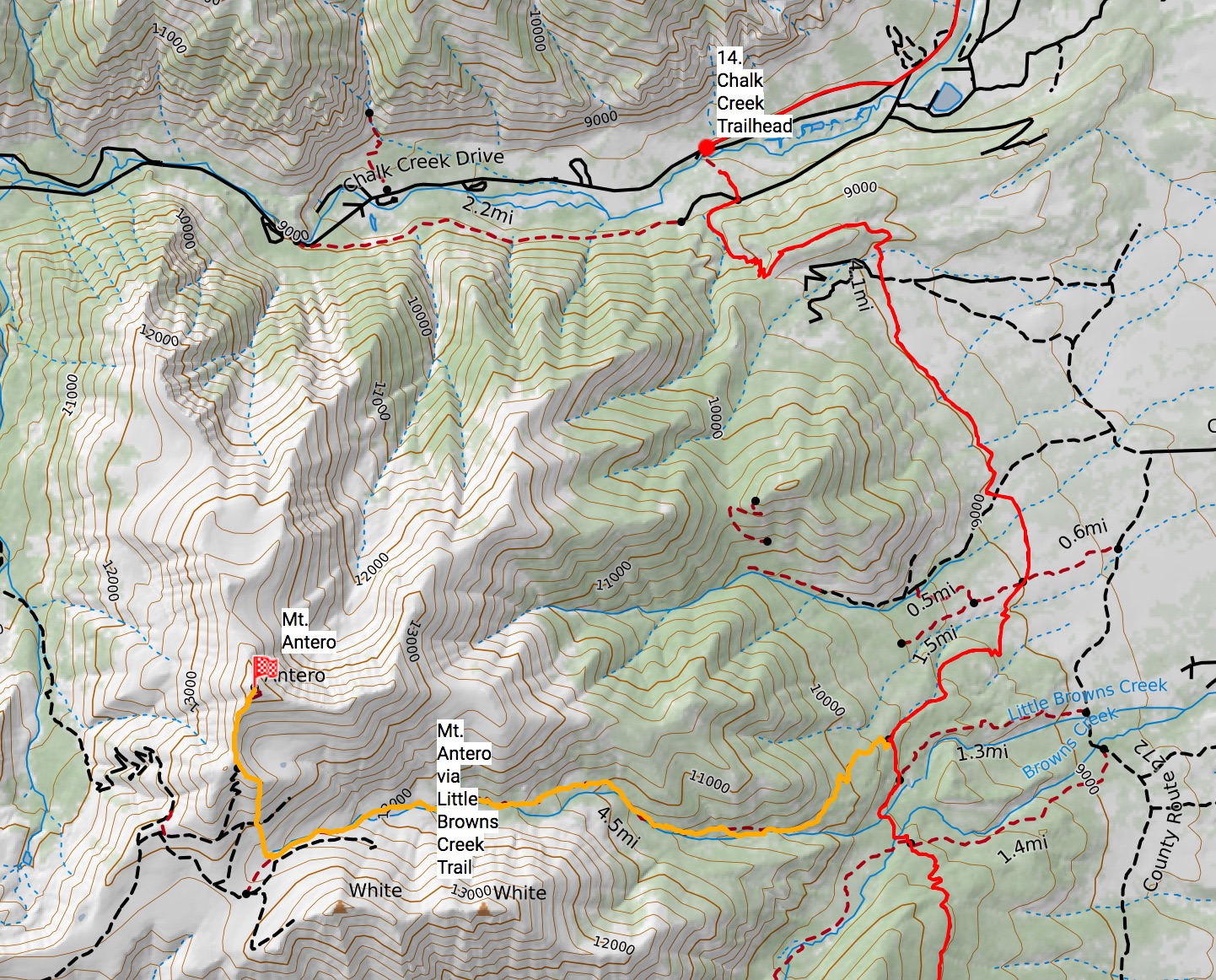
Mt. Antero
Mt. Antero can be accessed by taking the Little Browns Creek Trail from CT segment 14, which you’ll find 6.15 miles from the Chalk Creek TH (38.6699, -106.1817). Little Browns Creek Trail is a wonderful trail, but will intersect with the 4WD road to Antero, which will be a depart from the relative quietness of the CT. I usually hike a little to the east of the route up Antero’s south slopes to avoid the road itself, and come out near the final parking lot, a few hundred feet shy of the summit.
If on an MTB, you may opt to take off after Mt. Princeton Hot Springs and go west up Chalk Creek Drive to CR 277 – a rough 4WD road that will gain you access almost all the way to the summit. The road is popular with 4WD enthusiasts, so don’t expect a wilderness experience. (this route isn’t on the CalTopo map)
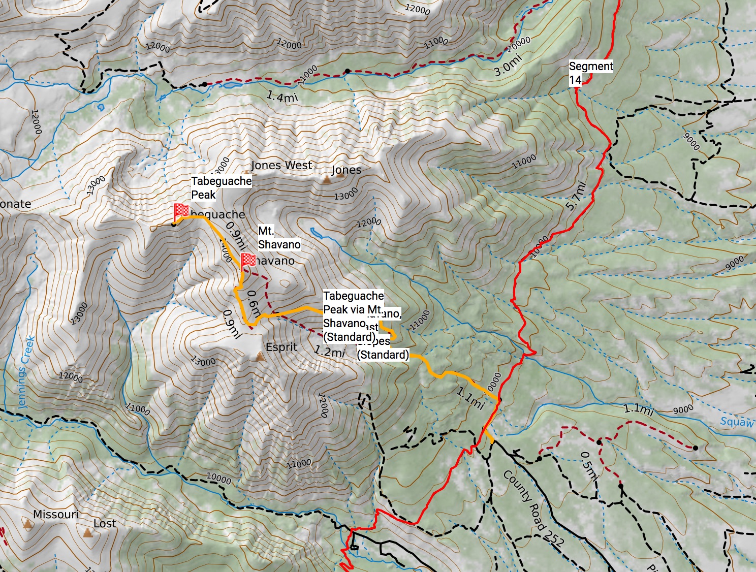
Shavano/Tabeguache
The standard, East Slopes Route to Mt. Shavano is accessed right of the CT, at Segment 14 (38.6017, -106.1959). It’s 12.6 miles from the Chalk Creek TH, but only half a mile from the Blanks Cabin TH (8.7 miles to HW 50). From Shavano, Tabeguache is approx. a mile further north on an easy, Class 2 ridge walk.
Mt. Ouray
A Centennial (but not a 14er), Mt. Ouray is 3.5 miles from Marshall Pass (38.4018, -106.2530).
San Juans
San Luis
The Northeast Ridge route of San Luis can be accessed right off the Colorado Trail at Segment 20, at the Eddiesville TH (38.0256, -106.8361). From this TH, it’s 6.75 miles to the summit.
Alternatively (and probably: preferably), you can take the South Ridge route for San Luis, also right off the Colorado Trail at Segment 20 (37.9716, -106.9242). From the Colorado Trail, it’s only 1.4 miles to the summit. This is a long route from the closest parking area outside of Creede, CO (West Willow Creek), but it’s much easier to access if you’re already on the CT.
West Willow Creek is also an out-of-the-way access point for the CT and will give you access to Creede for resupply. You’ll most likely want to hitch a ride down from West Willow Creek. The ride up is a popular 4WD route, but it may be spotty hitchin’ a ride.
If you don’t mind missing part of Segment 20, you can potentially go up the Northeast Ridge of San Luis, and down the South Ridge route (Class 1).

Half Peak
A Centennial (but not a 14er), Half Peak is only 1.3 miles from the Colorado Trail, on Segment 23 (37.8477, -107.4613). Leave the trail, and head north about 1.6 miles from the CT/CDT split.

Need Something Even More Challenging?! Slowlans
Check out the Slowlans route, which travels south to north, summiting the Colorado 14ers in a more direct line.
Edits:
- 10/18/18: The La Plata Peak and Mount Huron map images have been added. The Missouri Group route map image was in the incorrect spot, which has been fixed.
- 10/19/18: Adding route markers on the CalTopo map to mark where the trail junctions off the Colorado Trail are specifically, and linked those points to the descriptions on this post.
![]() If you’re enjoying this content, considering joining my Patreon to support future work.
If you’re enjoying this content, considering joining my Patreon to support future work.

[…] Simoni also has very detailed information on accessing the 14ers from The Colorado Trail. Complete with CalTopo maps, alt routes, and where dropping your pack for a side trip may be […]
Love your site! Great info! Thanks for sharing.
I’m thinking about doing your route. I have questions. Should I ask them here, or is there another, preferred method of communication.
Thanks.
Ask away here, I guess.
Great!
So, I spent 2 days on the Colorado Trail back in July with a BSA Venturing Crew. I talked with our guide about both through-hiking the CT and summiting 14ers. After that trip, I started thinking about doing both and subsequently found your site when searching for “Colorado Trail 14ers.” For the past few weeks, I have been thinking more and more seriously about following your route.
I am not able to take a month+ from work and family, so I would have to do the route in 1-week and 2-week increments. I would be driving from out of state.
My primary questions at this point are logistical. First, after hiking for a week or more, how do I get back to my car? Are there local services that shuttle hikers? Do I take a taxi/uber? Hitchhike?
Second, when does the weather typically get bad enough to make the trails inpassible? I read that the weather is still good and the trails are still open (not snowed over) through mid-September. But I can’t take off from work in September. The earliest I’d be able to start is the first week of October. Is that getting too late in the season? Would you recommend I wait until next year?
Thanks for any information and wisdom you can share!
I’m not sure of local shuttle services – that may be a good question to ask CT user groups, like you’ll find on FB. Depending on the area, the local hostels may have shuttles set up for ya.
October won’t (usually) seen snowed-over trails, but it does start to get a bit cold up there. You’re also going to start seeing daylight become a rarity. Certainly going to be the off-season for the surrounding areas as well, so tourist-centric services may not be running anymore. But, you won’t have any problems with thunderstorms!
‘
Thanks for the info!
I don’t have a problem with cold at all. I was primarily concerned with snow and possibly losing the trail. Most of the information I’ve read talks about the snow melt at the beginning of the season and when it’s safe to start hiking. I have found little information about when the snow starts at the end of the season and when to get off the trail. So thank you for the info.
I am currently moving forward with plans to do Segment 1-10 over two weeks starting October 7, finishing with a summit of Mount Massive, and then exiting to Leadville. I still need to figure out how to get from Leadville back to the Waterton Trailhead, but I expect I’ll figure something out. Was planning to call the Leadville Chamber of Commerce to see what transportation options they have in town.
Anyway, I’ll be keeping an eye on the weather as October nears. I’ll bail if I’m not comfortable with the forecasts, but I’m excited to do this. I’m happy to continue sharing my experience here if it’s helpful or interesting to anyone.
Mountain weather is always fickle, so who knows when we’ll be shut out. Looks to be pretty OK, weather-wise right now.
* Getting home: from Leadville (hitch from the trailhead, there should be ample traffic), there’s a bus line called the Summit Stage that will take you from Leadville to Frisco.
* From Frisco, take the Bustang West Line east, which will take you to Denver, Union Station.
* From Union Station, take the “C” line all the way south to Mineral Station.
* From there, you’re pretty close to the start at Waterton, and you could most likely Uber it from there.
Good luck!