120 miles, 3rd-4th Class, chossy – unrealized.
Route Description
The Continental Divide crossed the Sawatch Range South to North starting around Marshall Pass, near Pagosa Springs and exits somewhere near Tennessee Pass near Leadville in around 120 miles. Between these points, the ridge stays generally above treeline at an average elevation of over 12,500′. The challenge of the Sawatch Continental Divide Ridge Traverse is to hike this ridge from Marshall Pass to Tennessee Pass (or if you choose, the reverse direction).
So far as I personally know, it has not been completed in one continuous trip.
Map
You can research my own Caltopo Map at,
There are a few rough edges.
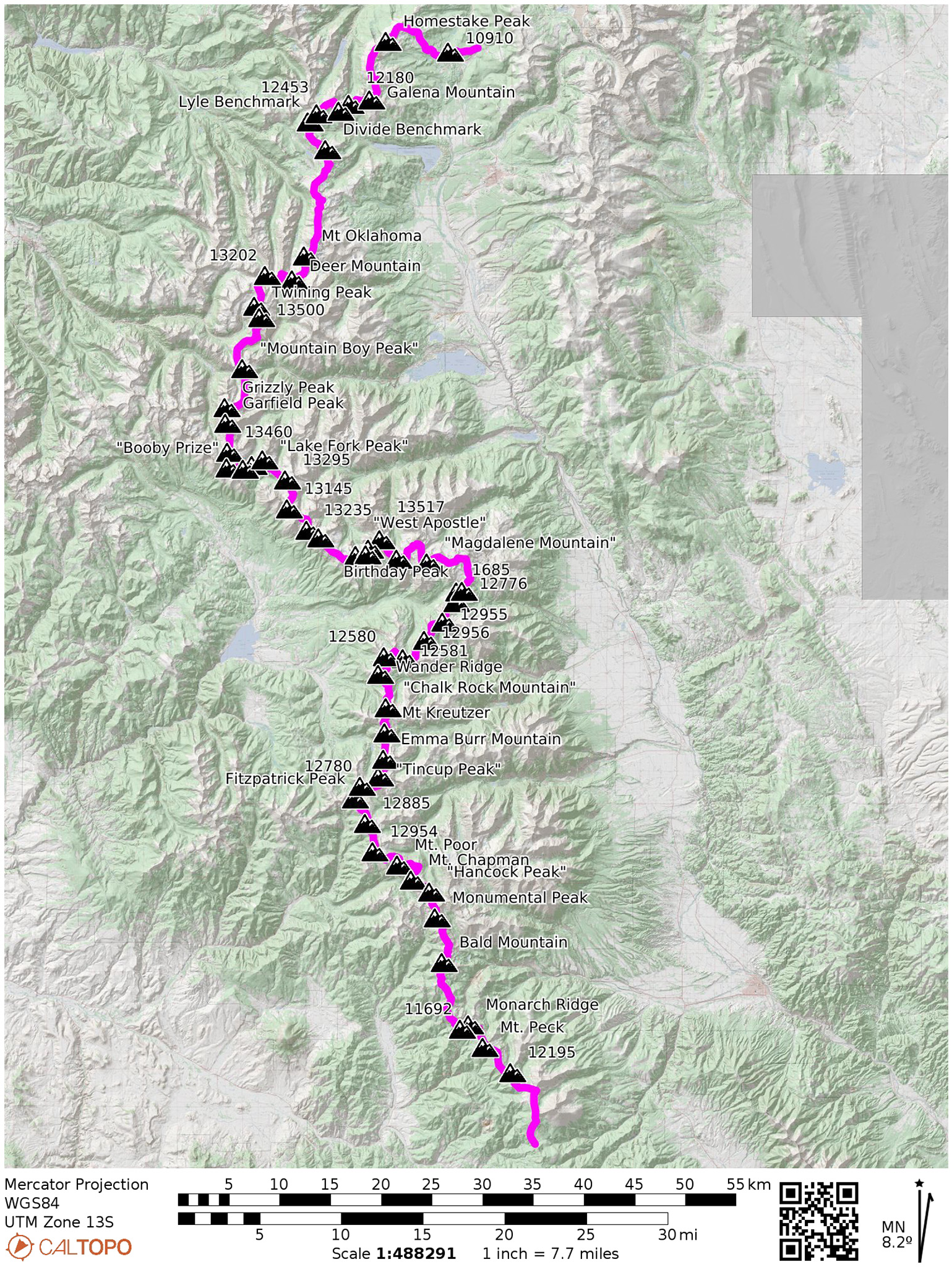
Peaks on the Route (North to South)
- 10910 – 10,910′
- Homestake Peak – 13,217′
- Galena Mountain – 12,900′
- 12180 – 12,180′
- 12510 – 12,501′
- 12458 – 12,458′ (bonus, just off ridge)
- Lyle Benchmark – 12,492′
- Divide Benchmark – 12,264′
- Bush-Ivanhoe Benchmark – 12,346′ (bonus <300′ prominence)
- Hunter-Fryingpan Wilderness HP/Mount Massive Far-Northwest Peak – 14,175′ (bonus, <300′ prominence, highest point of route)
- Mt. Oklahoma – 13,843′
- Deer Mountain – 13,763′
- 13220 – 13,220′
- 13556 – 13,556′
- Twining Peak – 13,721′
- 13541 – 13,541′
- “Igloo Peak” – 13,050′ (bonus, <300′ prominence)
- “Mountain Boy Peak” – 13,204′
- Grizzly Peak – 13,997′
- Garfield Peak – 13,778 ‘
- Red Mountain – 13,481′ (bonus, <300′ prominence)
- 13457 – 13,457′
- “Booby Prize” – 13,326′
- 12762 – 12,762′
- 12943 – 12,943′
- “Lake Fork Peak” – 13,333′
- 13305 – 13,305′
- 13145 – 13,145′
- 13251 – 13,251′
- 13258 – 13,258′
- “West Apostle” – 13,597′
- Ice Mountain – 13,960′
- “North Apostle” – 13,869′
- 13513 – 13,513′
- 13221 – 13,221′ (bonus <300′ prominence)
- “Pear Peak” – 13,459′
- “Magdalene Mountain” – 13,780′
- 13570 – 13,570′ (bonus, <300′ prominence)
- 12796 – 12,796′
- Birthday Peak – 12,752′
- 12685 – 12,685′
- 12769 – 12,768′ (bonus, soft-ranked)
- 12962 – 12,962′
- 12970 – 12,970′
- 12585 – 12,585 (bonus, just off ridge)
- 12598 – 12,598′
- Wander Ridge – 12,799′
- “Chalk Rock Mountain” – 13,064′
- Mount Kreutzer – 13,122′
- Emma Burr Mountain – 13,544′
- “Tincup Peak” – 13,351′
- 12782 – 12,782′
- Fitzpatrick Peak – 13,122′
- 12886 – 12,886′
- 12957 – 12,967′
- Mount Helmers – 12,878′ (bonus, soft ranked)
- Mount Poor – 12,455′
- Mount Arps – 12,398′ (bonus, soft ranked)
- Mount Chapman – 12,765′
- “Hancock Peak” – 13,111′
- Van Wirt Mountain – 13,026′(bonus, soft ranked)
- “Van Wit” – 13,244′ (bonus, soft ranked)
- Monumental Peak – 13,375′
- Vulcan Mountain – 12,982′ (bonus, soft ranked)
- Clover Mountain – 12,965′ (bonus, soft ranked)
- Bald Mountain – 12,859′
- 11814 – 11,814′ (bonus, soft ranked)
- 11702 – 11,702′
- South Monarch Ridge – 12,912′
- Mount Peck – 12,209′
- “Peel Point” – 12,160′ (bonus, soft ranked)
- 12202 – 12,202′
- South Chipeta Mountain – 12,874′ (bonus, soft ranked)
History and Attempts
(this is not supposed to be an exhaustive list of every attempt)
Unlike other ridge traverses, there doesn’t seem to be any historical attempts to traverse the range via the main ridge, like the Sangres Traverse in 1961 by Bill Arnold, Lester Michel, and Jim Michel or Carl Pfiffner’s musings of traversing the Front Range from Berthoud to Milner Pass.
More recently, Glenn Dunmire made it a personal project to walk to entire Continental Divide in the United States. In this old Backpacker article, he does mention that he has completed most of Colorado, which would mean this section as well. It’s unknown to me how he tackled the Sawatch section, but I would guess in separate trips. Still, it’s worth mentioning that the idea of traveling the ridge of the Continental Divide is not new.
I have much of Colorado and Wyoming done, and some of New Mexico, and that’s taken 100 days. There’s still Glacier and the Wind Rivers. If it weren’t for the realities of life, I’d be done by now. But I have a job, and I’m married, and I’d like to stay that way.
Glenn Dunmire
2021, 2022: Scott Sidener
Sidener started in Marshall Pass and went north to Tennessee Pass in the summer of 2021. He reports leaving the ridgeline just before Pear Pear, dropping onto the Colorado Trail citing very difficult climbing and safety concerns, then rejoining the ridge later at Lake Anne Pass. This has been the most complete trip known to date. His total trip took 7 days, 15 hours and Scott reported 133 miles hiked with 120,000 feet of elevation change.
There is no way I can do justice to describing this adventure to anyone.
Scott Sidener
In 2022, Sidener reports going back to the ridgeline:
“I was so disappointed that I missed the good stuff [at] Pear, 13513, the Apostles and Ice [Mountain], that I went back the next year and did them to fill in the gap. I did a big loop from Winfield, up to Pear lake saddle then on past lake Anne pass to 13145 and Virginia peak staying on that ridge all the way back to Winfield. It was a blast!”
Other than the Birthday/Harvard Traverse, Scott reports doing the entire ridge between Marshall and Tennessee Passes in these two trips.
2021: “headsizedburrito”
14ers.com user “headsizedburrito” (he prefers to stay anonymous) started at Monarch Pass, and went North to Lake Ann Pass, and documents it in this trip report.
2022: Justin Simoni
I decided to buck the trend a bit, and start from the northern terminus at Tennessee Pass, and travel south. Terrain from Tennessee Pass to Mount Massive Far Northwest Peak is relatively mild, but kicks up in difficulty from there. I bailed out right before “Booby Prize” peak, having a funny feeling the sky was about to open up in a torrential downpour (and was correct). I shot and edited a video of the attempt, which I feel gives a good feeling of the type of loose terrain you’ll have to negotiate for miles and miles.
Difficulties
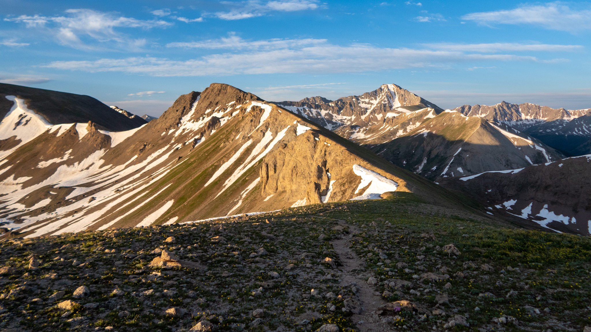
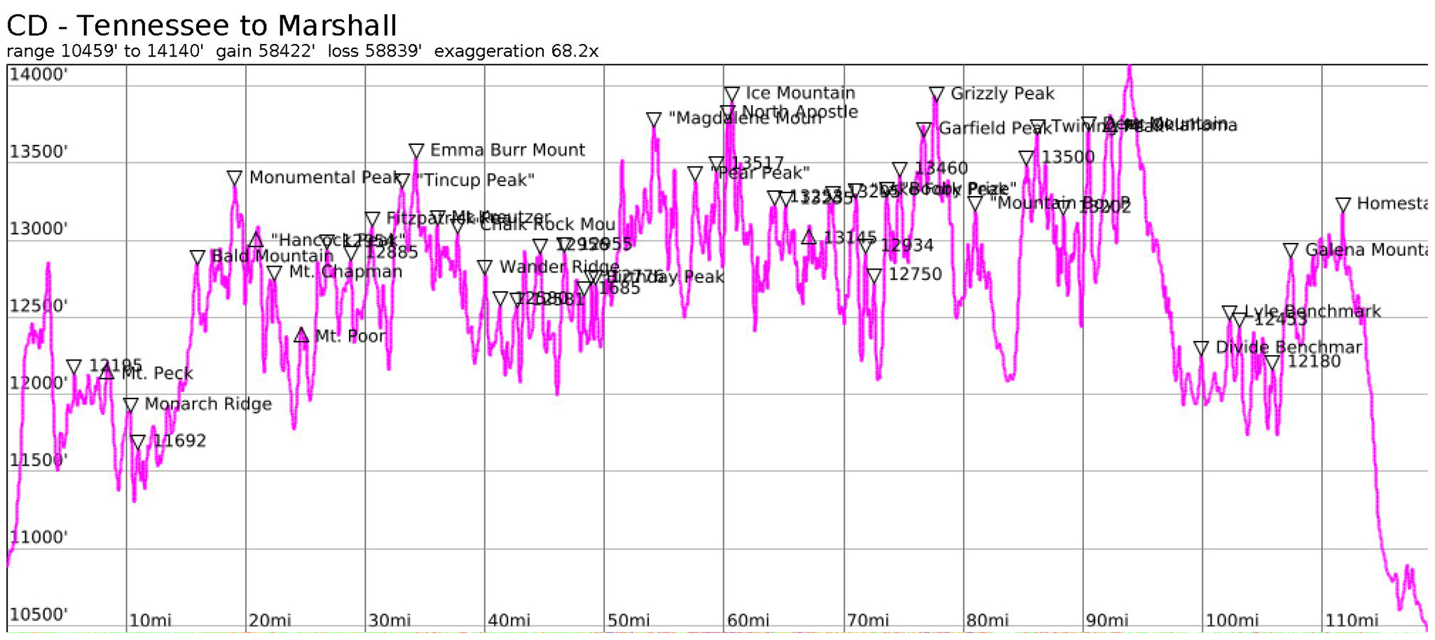
Between these Marshall Pass and Tennessee Pass, one will summit approximately 50 peaks with >300′ of prominence. The ridge itself stays above 12,000 contiguously for over 66 miles from Tincup Pass to Hagerman Pass.
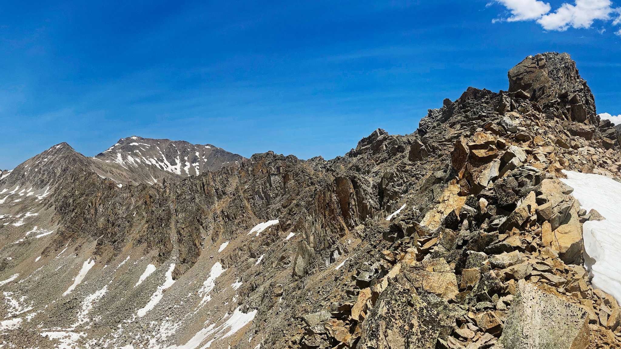
Difficulty ranges from the odd Class 1 trail, to easy Class 2 talus walks, to absolute nightmare choss heaps of teetering rubble. I’m reticent on grading any of the most difficult sections more than Class 4, as the geology generally doesn’t allow for better rock quality where hand and foot holds stay in place, but one should temper expectations on any attempt towards finding very difficult climbing which does not fit easily within the YDS grading scheme.
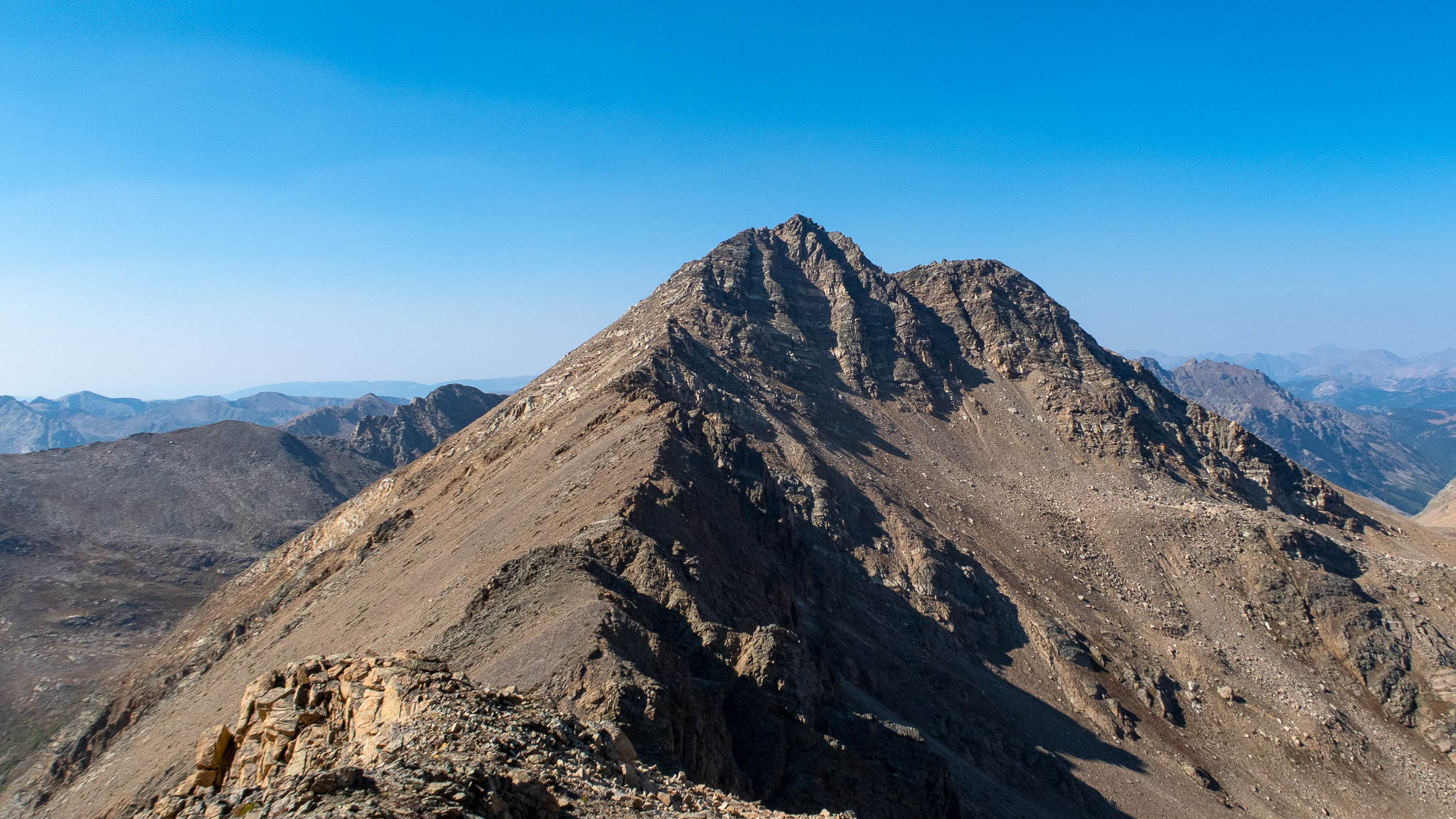
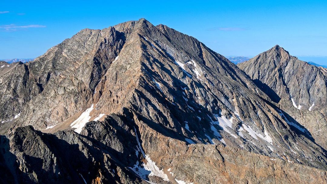
The Sawatch Range of Colorado is home to 15 14ers, whose standard routes are relatively mild in technical challenges. If judged by these routes, one would think the rest of the range’s lower mountains are just as easy. This would be a grave mistake. What’s also interesting is that none of the lofty Sawatch 14ers have summits that are on the Continental Divide. The closest is a fairly unremarkable sub-peak of Mt. Massive: “Mount Massive Far Northwest Peak”. There are a few Centennials on the ridge, including Mt. Oklahoma, Grizzly Peak, Ice Mountain, and North Apostle Peak.
Nowhere is the rock quality better illustrated than on the ridgeline between Birthday Peak and Mt. Harvard (or more specifically, the lower Pt. 13570). I have myself reconned this part of the route after watching a video showing someone bailing on the ridgeline traverse themselves. I got stymied on the first major tower, having climbed up it to find an ancient and now unreliable rappel station made up of a slung rock and single carabiner — a good chance put in by Dunmire years ago — and no good way to downclimb off. Rock was so loose, one could simply pluck pieces of rock from the side of the ridge itself. I decided myself to back down and try another day.
A few parts of the ridge are often visited as day trips, such as Ice Mountain and North Apostle. Ice Mountain is known as one of the harder, looser Centennials in Colorado to summit and it illustrates the general feel of terrain you will find throughout the looser parts of the ridge. If you can visualize yourself doing the route from saddle of North Apostle and Ice Mountain for multiple hours a day, for multiple days in a row: you are ready for the Sawatch Continental Divide Ridge Traverse.
Do not underestimate this line. Before this trip, I myself had thought the entire ridgeline must be fairly tame and nothing but a warmup to more difficult objectives like the Sangre de Cristo Range Traverse. I wrote up my plans on a future attempt, and added side-trips off the main ridgeline to visit close-by 14ers and Centennials in order to add more difficulty.
One large problem with my initial plans was that the mapping software I used, Caltopo, was seriously underestimated elevation gain/loss, throwing off my trip time estimates. They’ve since changed the default settings to prevent this type of issue, which I’ve documented here.
Water
Water can be rare on this segment of the Continental Divide, with most water being locked up in snowfields. Some small lakes are found near the ridge, or directly on the ridge, and some surprisingly located springs can also be found.
Comparing with the Colorado Trail, Continental Divide Trail, Nolan’s 14
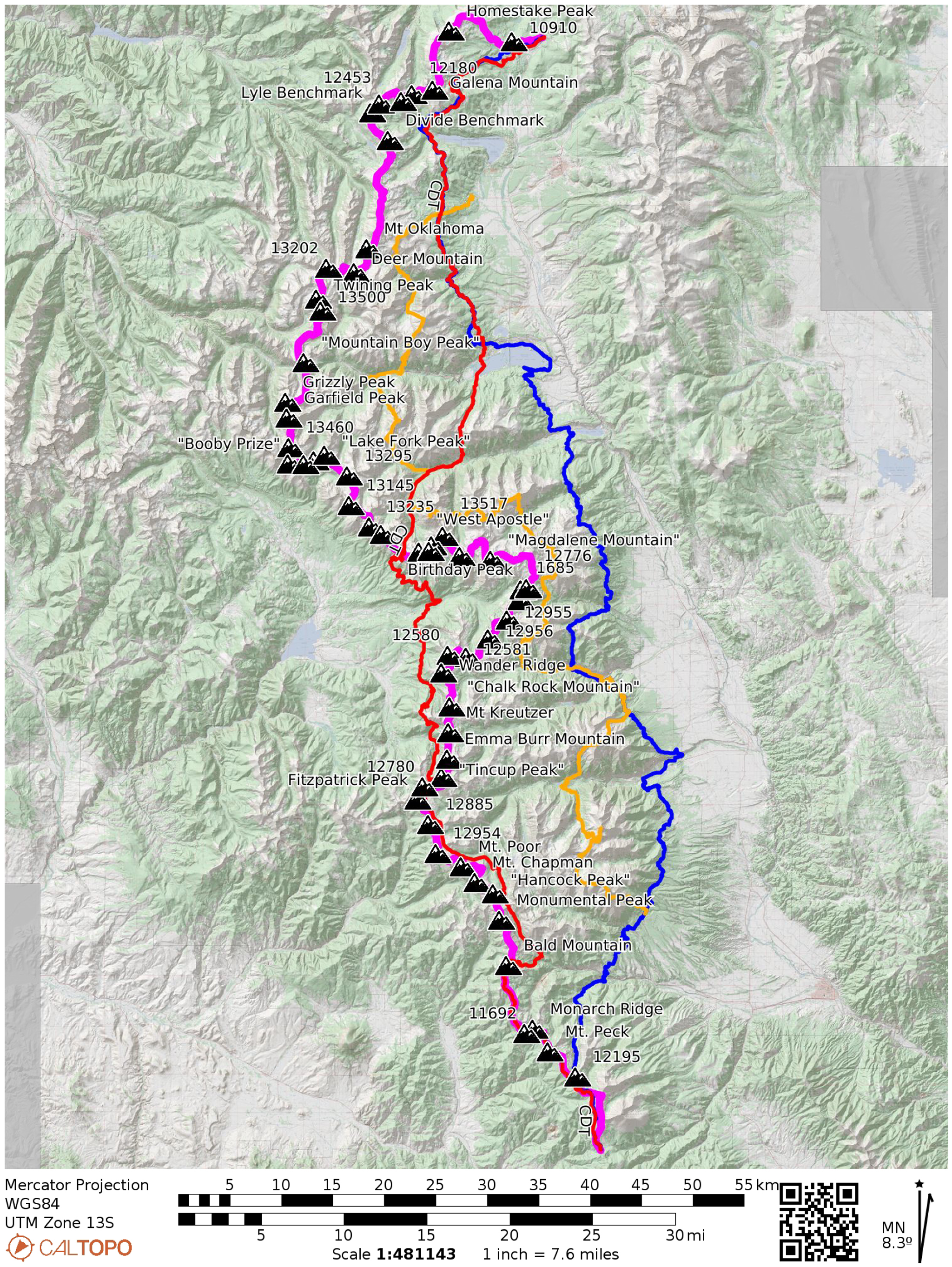
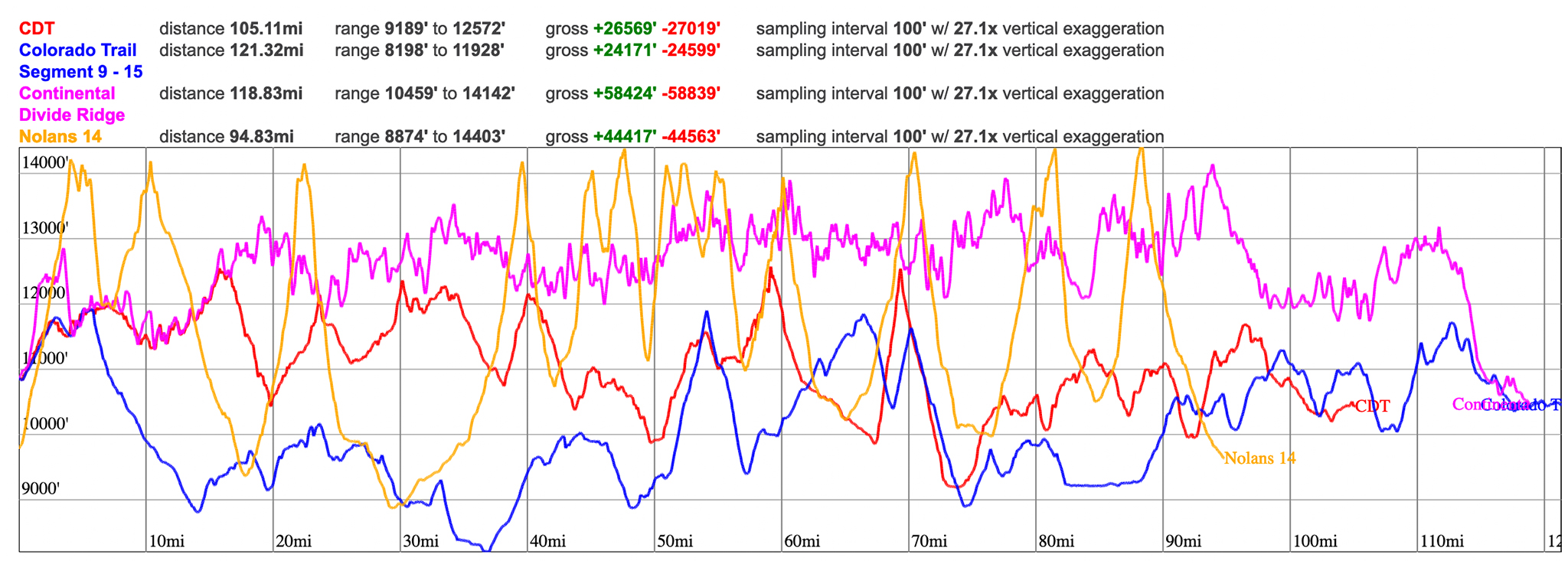
Both the Colorado Trail and Continental Divide Trail make their way through the Sawatch (and share a origin/terminus at Marshall/Tennessee Pass, even!) and Nolan’s 14 happens completely in the Sawatch. Compared to hiking on the Continental Divide Ridge, both the CT and CDT are very roughly the same distance, but only half of the elevation gain, both staying for the most part far lower than the ridge itself. There are a few places the CT/CDT either follow the ridge, or cross over the ridge at a pass. Nolan’s 14 stays fairly distant from the ridge, as no 14er summits are located on the Continental Divide Ridge.
Nolan’s 14 elevation is higher absolutely, hitting 14,000+ feet 14 times to the ridge’s 1, but also drops much, much lower than the ridge in almost as many times. Nolan’s 14 is also a little shorter. Of course, but the CT and CDT are on trails; Nolan’s 14 is on mixed ground of trails and off-trail. The Continental Divide will be mostly off trail over much more difficult terrain.