Work in Progress
Bikepacking to the Colorado 14ers is currently being written and published publicly. Get news and updates by joining the Facebook group, Instagram, Twitter, subreddit, and mailing list.
Introduction
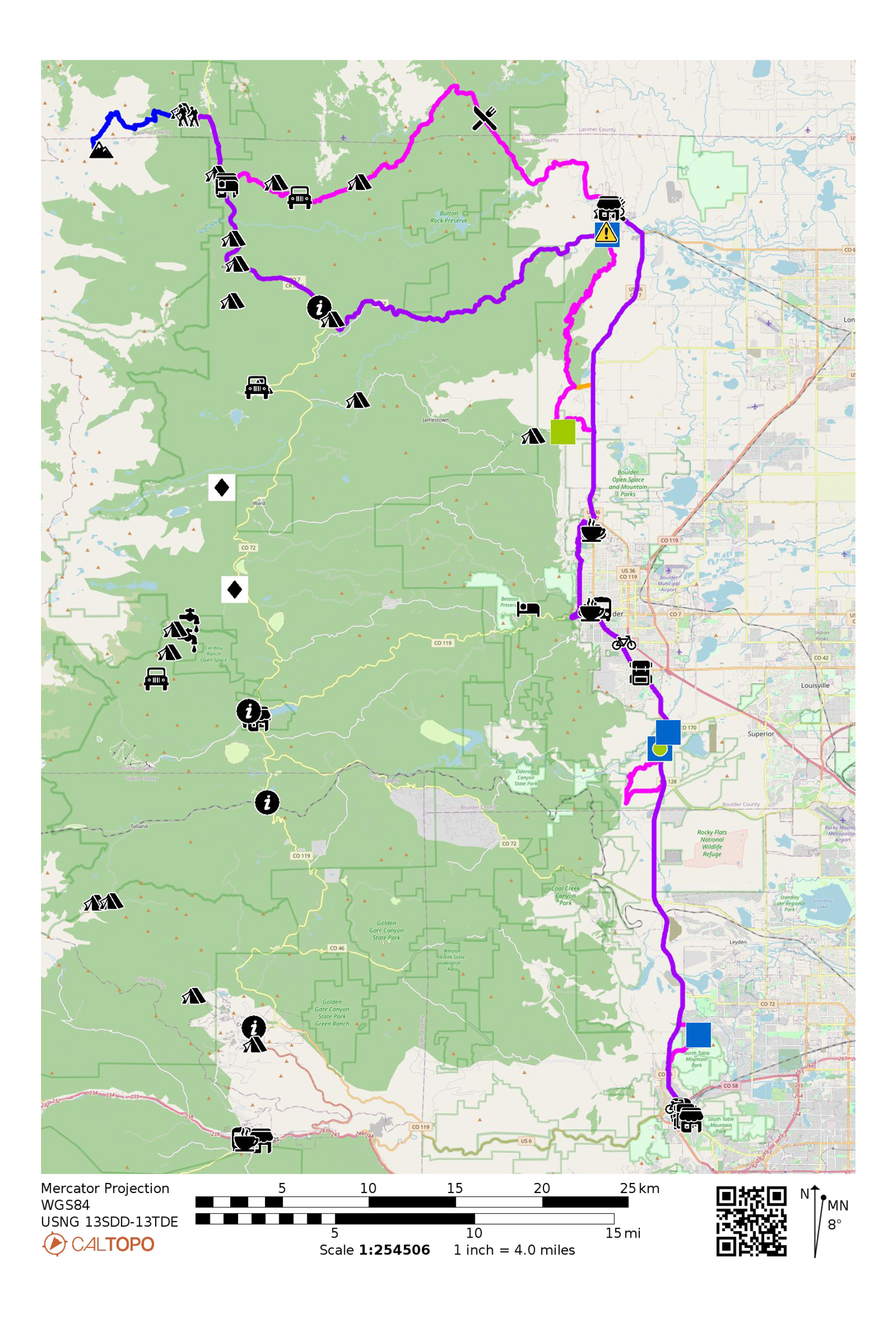
From the high country, back down to civilization! Segment #5 ties up the Tour 14er: Front Range, taking you from the East Longs Peak Trailhead back to the city of Golden.
The MTB Narrative will take you out of the Tahosa Valley via the Johnny Park 4WD track, then samples some more Front Range MTB trail systems including Heil Valley, Marshall Mesa, Eldorado Springs and North Table Mountain.
The Road Narrative rockets you down St. Vrain Canyon to Lyons, then through Boulder, and finally to Golden. Once back on the plains, dispersed camping mostly disappears, so it’s suggested to find a room, or plan on riding to the terminus in one big push.
MTB Narrative

- Mileage: 72.78 miles
- Elevation Gain/Loss: 4580’/8295′
Leave the East Longs Peak trailhead, and ride down the Longs Peak Road, heading east. After about a mile, turn right on CO 72. Follow CO 72 to Meeker Park. Services for Meeker Park are listed in Segment #4.
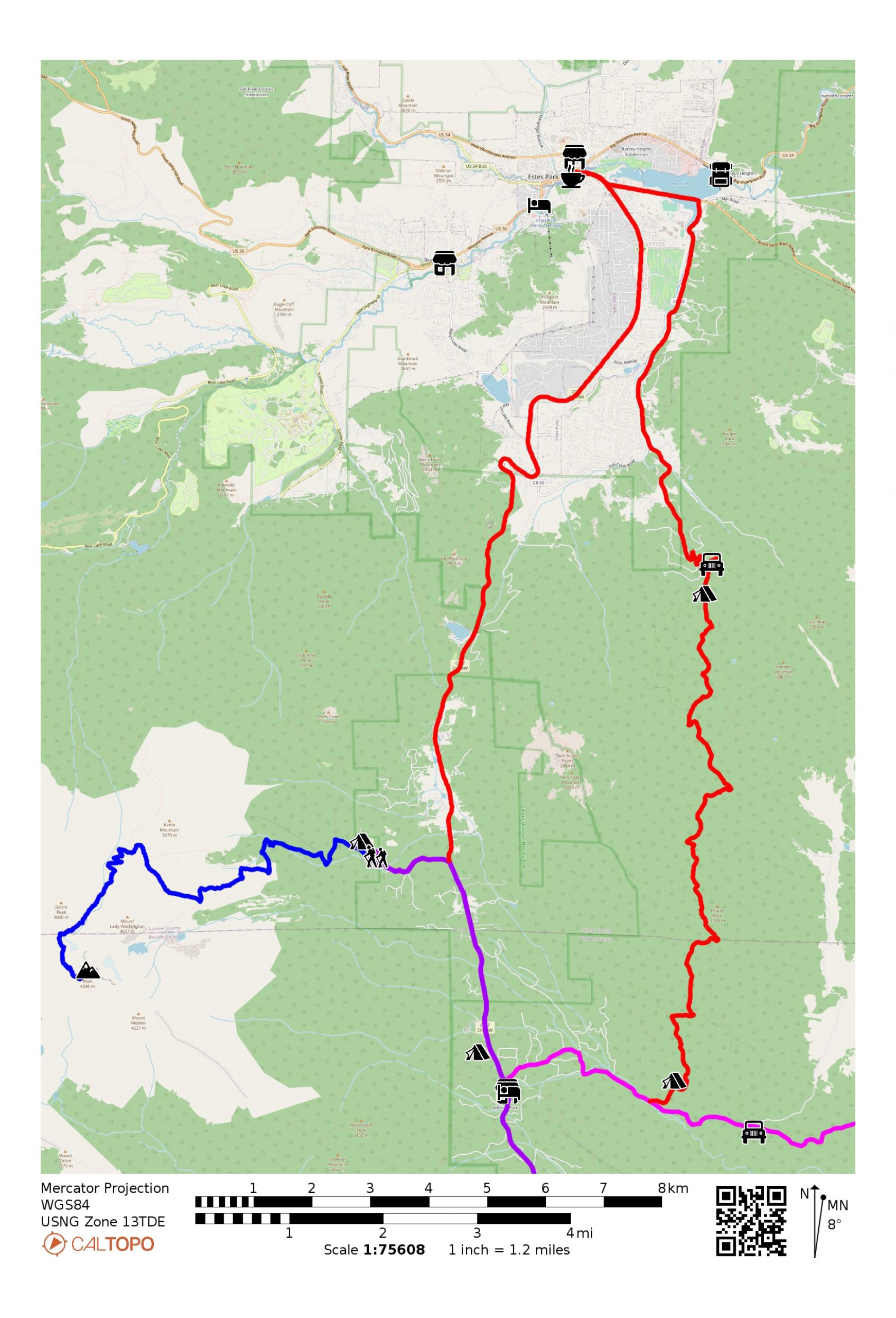
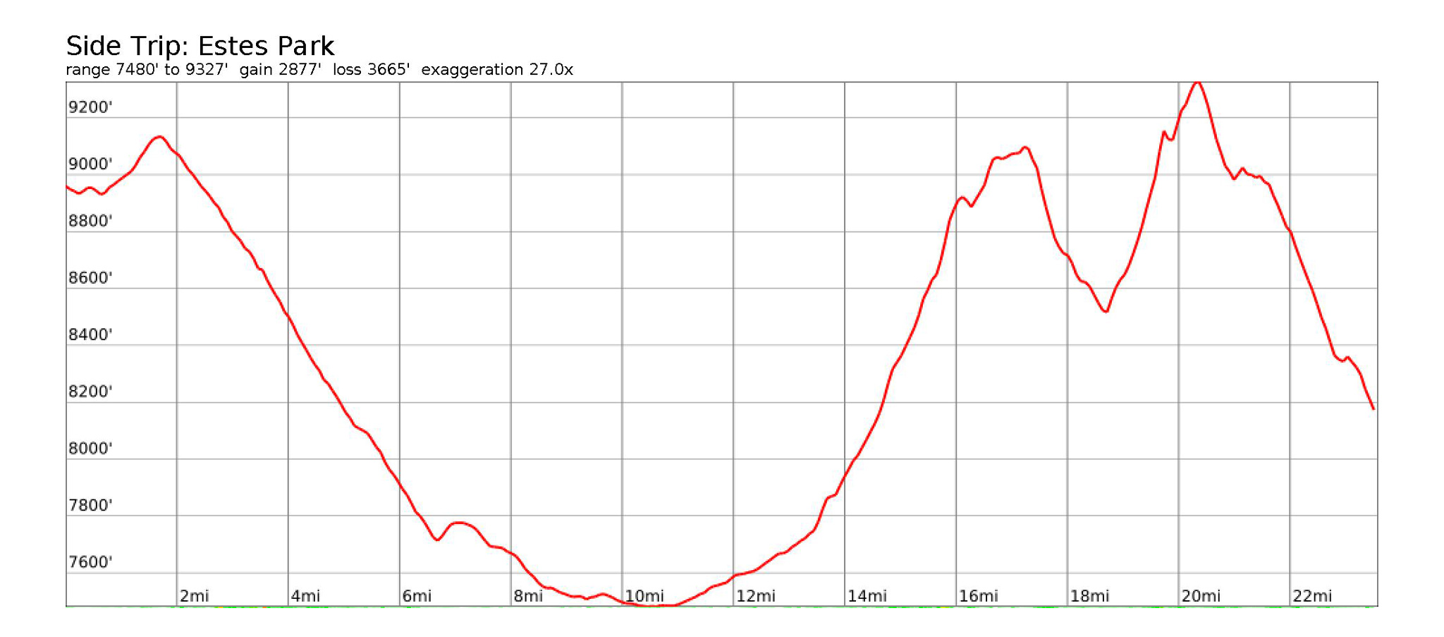
Side Trip: Estes Park
- Surface Type: Road/Gravel/4WD
- Mileage: 23.59 miles
- Elevation Gain/Loss: 2879’/3666′
- Camping: Yes
Estes Park is the main gateway into Rocky Mountain National Park and has all the trappings of a tourist town. Enjoy completing the Front Range 14ers with a little town time before once again spiriting away into the forest.
Instead of heading south on CO 72, take a left onto CO 72 and head north, rocketing down to Estes Park. We’ll rejoin the MTB route on FSR 118.
Estes Park Services
- Groceries: Safeway
451 E Wonderview Ave
970 586 4447 - Groceries: The Country Market of Estes Park
900 Moraine Avenue
970 586 2702
https://the-country-market-of-estes-park.business.site - Coffee: Kind Coffee
470 E Elkhorn Ave
970 586 5206
https://www.kindcoffee.com - Lodging: Estes Park Adventure Hostel
341 Moraine Ave
720 387 8944
https://coloradomountainschool.com/product/estes-park-adventure-hostel/ - Gear: Estes Park Mountain Shop
2050 Big Thompson Ave
970 586 6548
https://www.estesparkmountainshop.com
Once in Estes Park, travel east on HW 36. Turn right onto Fish Creek Rd for 2.8 miles, then turn onto Little Valley Road. The road will climb up switchbacks as it crosses into National Forest. Little Valley will turn into Pierson Park/119. Good camping options start about a half a mile from the last switchback and dispersed camping will continue to be available until Cabin Creek, ~14 miles later.
Continue on Pierson Park/119 as it continues to become rougher. After a few miles, you’ll reach the massive mudslide that has completely taken out the road. Cross the mudslide, find the track again, then continue.
After a short descent, you’ll reach Elk Park Road/82E Take a left onto Elk Park Road/82E heading east to merge onto the Segment #5 MTB narrative.
Turn left on CR 82 heading east. At the road junction, turn right on now CR 82E, heading south, then back east. At the fork in the road, go right onto FSR 118/Johnny Park heading east (82E will go north). FSR 118/Johnny Park will enter into National Forest, so dispersed camping will be open to the majority of this track. FSR 118/Johnny Park will soon itself turn northeast and become a 4WD track. FSR 118/Johnny Park will turn into CR 47 at the Coulson Gultch trailhead. Follow CR 47 northeast to its terminus onto HWY 36.
Turn right onto HWY 36. Enter the township of Pinewood Springs
Pinewood Springs Services
- Pie!: Colorado Cherry Company
https://www.coloradocherrycompany.com
303 823 2324
Continue southeast on HWY 36. Shoulder is adequate and the going is mostly downhill. Enter the town of Lyons. If you need services/supplies, ride into the town of Lyons in earnest by taking a left on Broadway heading east. Paid campsites are located on the west side of town.
Lyons Services
- Groceries: St Vrain Market, Deli & Bakery
455 Main Street
303 823 5225
https://www.stvrainmarket.com - Bike Shop: Redstone Cyclery
54 Main Street
303 823 5810
https://www.redstonecyclery.com - Lodging: Lyons Adventure Lodge
https://lyons.a-lodge.com - Food: Oscar Blues
303 Main St
http://oskarbluesfooderies.com - Coffee: The Stone Cup
442 High St
303 823 2345
thestonecup.com
Lyons Camping
- LaVern M. Johnson Park
600 Park Dr
303 823 6150
https://www.townoflyons.com/351/Camping-at-LaVern-M-Johnson-Park https://www.reserveamerica.com/explore/lavern-m-johnson-park/PRCG/1063250/overview
The Wapiti Trail is currently closed due to the Calwood Fire. Continue on the Road/Gravel narrative by taking Broadway east, then follow HWY 36 South into Boulder.
Bear right and skirt town by taking CO 7 south.
Turn Left on Old South Saint Vrain Road heading south. Take a left on Red Gultch Road. Enter onto Picture Rock Trail, heading initially east, then south. Picture Rock heads up into the Heil Valley Ranch trail system. At the end of Picture Rock, take the Wild Turkey Trail left heading south. At the trail junction with the Ponderosa Trail, take Ponderosa left, heading south. At the trail junction with the Wapiti Tail, take Wapiti left, heading south. Wapiti will end at the south Heil Valley trailhead. Continue South on Green Canyon Road.
Green Canyon Road ends at Lefthand Canyon Road. Take Lefthand Canyon right heading south.
Camping Near Boulder
- Lefthand Canyon OHV Dispersed Camping
40.1070, -105.3228
Free, dispersed camping near Boulder is a difficult and tricky errand. One of the closest National Forest access is the Lefthand Canyon OHV, just off route on Left Hand Canyon Road. Despite its name, OHV riding is currently not allowed, and the trail system is mostly used by mountain bikers. The terrain is steep though, so finding a flat area to set up a bivy will be difficult. Left Hand Creek will make a passable water source, but treat your water, as communities dot the area up drainage.
Turn left onto Olde Stage Road heading south. Then turn left onto the Joder Ranch Trail heading east. Jorder Ranch will take you somewhat circuitously east back onto HWY 36. Take a right onto HWY 36 heading south. Take HWY 36 into Boulder.
North Boulder Services
- Coffee: Amante Coffee North
4580 Broadway
303 4489999 - Bike Shop: Boulder Cycle Sport North
303 444 2453
https://www.bouldercyclesport.com
Welcome to Boulder! This route will keep you away from most of the bustle of the city, but many of the services we highlight will be close enough to access just off-route.
Finishing in Boulder
The rest of the route through Boulder, then onwards to Golden will be much busier than what you have probably experienced since your started way back on Segment #1. If that’s not appealing, take the Flatiron Flyer Bus from the Downtown Boulder Bus Station to Union Station to end in Denver. From Union Station, get onto the West light rail line to finish up in Golden.
Turn right onto Broadway heading south. Turn right onto Lee Hill Road heading west. Turn left and enter the Foothills South Trail. This trail is well maintained gravel. Turn right onto Wonderland Lake Trail after a small descent. Wonderland Lake will be to the east. Continue south, and leave the Wonderland Lake Trail at Poplar Avenue. Cross the street and pick up the concrete Wonderland Lake Path heading south. Leave the path at Wonderland Lake Road. Take a right on Wonderland Lake Road heading south. At Linden, turn right heading west, then turn left heading south onto 4th Street. This starts out as a concrete path with a gate across it, but will widen up after passing a few absolutely enormous mansions. Take 4th Street south until Spruce Street. Take a right on Spruce Street heading west, then turn left onto a multi-use path heading south until Pearl Street.
Central Boulder Services
- Lodging: Boulder Adventure Lodge
91 Fourmile Canyon Dr.
303 444 0882
https://a-lodge.com
- Bike Shop: University Bicycles
839 Pearl Street
303 444 4196
https://www.ubikes.com - Coffee: Trident Coffee
940 Pearl Street
303 443 3133
https://www.tridentcafe.com/ - Bus Station: Downtown Boulder Station
1800 14th St
(303) 299-6000
Turn right onto Pearl Street heading west. Near Settler’s Park, pick up the multi-use path that starts on the sidewalk between a parking lot, and the park itself. The path will turn south and go under Canyon Street into Eben G. Fine Park. Once through the underpass, Turn left and head onto the Boulder Creek Path heading east. After you pass under Broadway, you’ll pass under Arapaho Avenue. Afterwards, turn right onto the Broadway Path heading south, which will parallel Broadway closely after a brief climb. The CU Boulder will appear to your left.
Cross Regent Drive and before the bike path practically runs into Kitterage Loop Drive, turn right to go through an underpass across Broadway, then turn left to keep following Broadway now on the west side. Continuing Broadway traveling generally southeast. The bike path will merge with Sunnyside Lane towards Table Mesa Drive.
South Boulder Services
- Bike Shop: Trek Bicycle Boulder
2626 Baseline Road
303 413 0228
https://www.trekbikes.com/us/en_US/retail/boulder/ - Gear: Neptune Mountaineering
633 S Broadway
(303) 499-8866
https://neptunemountaineering.com/
Follow the Broadway bike path system – the route will cross under Broadway under again near Darley Avenue. The path will end and dump you on Marshall Road heading south. Enjoy a slice of old Boulder weirdness, as you enter a sleepy neighborhood.
Turn Right on Eldorado Springs Drive heading generally southwest. Turn left at the Marshall Mea Trailhead, and ride onto the Coal Seam Trail heading west. Take the Coal Seam Trail generally southwest as it parallels CO 93/Foothills Highway. The trail system will go across under the highway and turn into the Community Ditch Trail. Turn left onto the Dowdy Draw Trail heading south. The Spring Brook Trail will come towards you on your right, but continue south on Dowdy Draw. Dowdy Draw will turn left at a switchback, and climb out of the drainage you’ve been riding and meet up with the Flatirons Vista Trail. Grab your camera and take a photo of the Flatirons behind you to the west! Keep riding east until you reach CO 93/Foothills Highway.
Turn right onto CO 93/Foothills Highway heading south and get ready for some highway riding all the way to Golden. Riding here is on a good shoulder, and there’s not too much traffic that’ll be turning to the west, although it’s not as pleasant as the rest of this route network. Dream of pizza and beer that awaits you so soon in Golden.
Turn left onto W 58th avenue heading east, the turn onto the North Table Mountain Northside Trailhead for the last bit of singletrack on the route. You’re almost finished! At the trail junction, turn left to head southwest onto the North Table Loop Trail. The Mesa Top Trail will come at you on the left, but stay on the North Table Loop Trail, trending generally southwest.
Exit the trail at the North Table Mountain Park West Trailhead and kiss the dirt goodbye. Turn onto the Highway 93 trail heading south, which parallels the highway. Turn left onto Pine Ridge Road heading east, then right onto North Ford Street heading south. Take North Ford Street all the way to 10th street, and take a right on 10th Street heading southwest. Ride one block to 9th street and meet up with your starting point.
Congratulations! You’ve completed the Tour 14er: Front Range!
Road Narrative
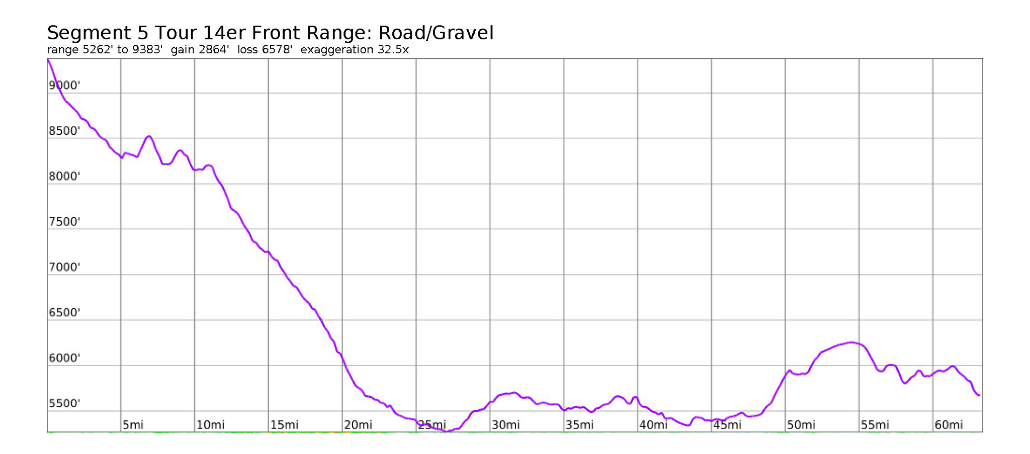
- Mileage: 63.41 miles
- Elevation Gain/Loss: 2865’/6579′
Leave the East Longs Peak trailhead, and ride down the Longs Peak Road, heading east. After about a mile, turn right on CO 7. Follow CO 7 through Meeker Park and Allenspark to the junction with CO 72. Continue on CO 7 east towards Lyons. With a slight tailwind, you may be able to almost reach Lyons without a single pedal stroke!
Enter the town of Lyons. Services are listed in the MTB Narrative. Turn right onto Broadway heading east. Broadway will merge back into two-way Main Street, and head southeast. Turn right onto HWY 36/CO 7 heading south. Take this road all the way to Boulder. The road can be busy, especially on a summer weekend, but the shoulder is generous, and there’s not too many right turns to be made. Local cyclists will be out in full force.
Follow the MTB Narrative through Boulder, to the end of Marshall Road. Take a right onto Eldorado Springs Drive heading west, then turn left onto CO 93 heading south. Take CO 93 all the way to Golden.
Turn left onto Pine Ridge Road heading east, then turn right onto North Ford Street heading south. Take Ford Street all the way to 10th street and turn right on 10th for one block to Washington.
Congratulations! You’ve completed the Tour 14er: Front Range!
Work in Progress
Bikepacking to the Colorado 14ers is currently being written and published publicly. Get news and updates by joining the Facebook group, Follow us on Instagram, join our subreddit, and mailing list.
You can support its development by purchasing items through the affiliate links on this site: check out the gear reviews, as well as the items below: