Milner Pass to Berthoud Pass along the crest of the Continental Divide
~75 miles, Class 2 – low 5th Class
August 2020, ~3 days 17 hours Solo + Unsupported, First Known Traverse
The Route
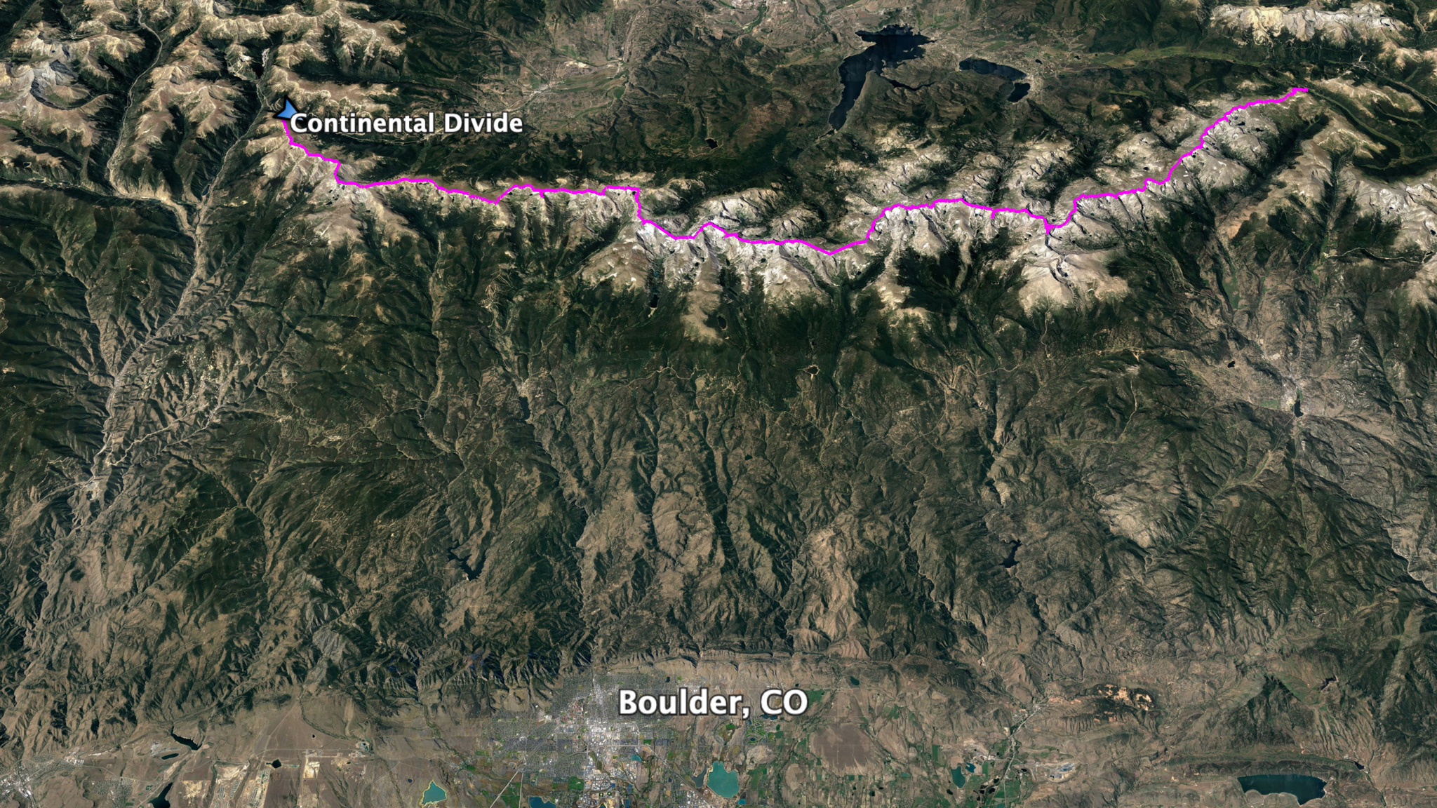
The mountains along the Continental Divide provide the backdrop to the city I live in: Boulder, CO. From town, nothing can be seen beyond their sheer, rocky, glacier-choked east faces. The ridge line itself invites one to come explore their craggy features, beaucoup exposure, and long expanses of carpeted-in-tundra plateaus.
Between Milner Pass located in Rocky Mountain National Park on Trail Ridge Road, and Berthoud Pass closer to I-70 on Highway 40, one will find over 50 named points and peaks located right on the Continental Divide. These passes are about 45 miles apart as the crow flies. No other paved roads are found between these two passes and no other roads – paved or otherwise, can be crossed via motor vehicles. The rest is mostly National Park and Designated Wilderness. The wandering ridge, if followed exactly at its apex, is around 75 miles long.
Route History
In my research, I was surprised to find that there hasn’t been a recorded report of anyone traversing this section of ridge proper by foot. This seems extremely hard to believe, as the concentration of runners, backpackers, mountaineers, and world-class climbers just in the immediate area is very high, and the line to traverse is itself obvious. But it does take a special blend of ultra-running fitness paired with technical climbing skill to be able to safely traverse the ridge.
The earliest known record of anyone attempting this traverse is Bill Briggs, who attempted it on August 7th, 1979 from Milner Pass, but ended his attempt on Pawnee Pass after 27 hours (a very fast pace). Others, including Buzz Burrell have shown interest in the route. Burrell is credited as being the first to finish the L.A. Freeway route, which follows the Continental Divide from Chiefs Head (via Longs Peak, then Meeker – a cruxy section), to South Arapaho, then descending to Fourth of July TH.
Glen Dunmire – the same Glen Dunmire that is credited to have been the first to bicycle to all the 14ers and summited them along with his brother Pete, has had a long-standing project of hiking the exact Continental Divide (story in Backpacker, 2009), but it’s not known if he’s done the section between Milner and Berthoud, and if he did, if he did it in one push.
Strangely enough, even before I finished my own traverse, Chris Harkness (trip report) had started his own successful traverse of the line, becoming the second person to have finished it in as many weeks.
Continuing with this 2020 Zeitgeist trend, Nick Pedatella and Ryan Smith completed their own traverse of the route starting on September 2nd, 2020.
Finally (and if one can even believe) Oak Nelson has self-reported his own similar traverse from Milner Pass to Rollins Pass on foot starting on 9/3/20, again being on the route at the same time as Pedatella and Smith.
I anticipate many more traverses in the future.
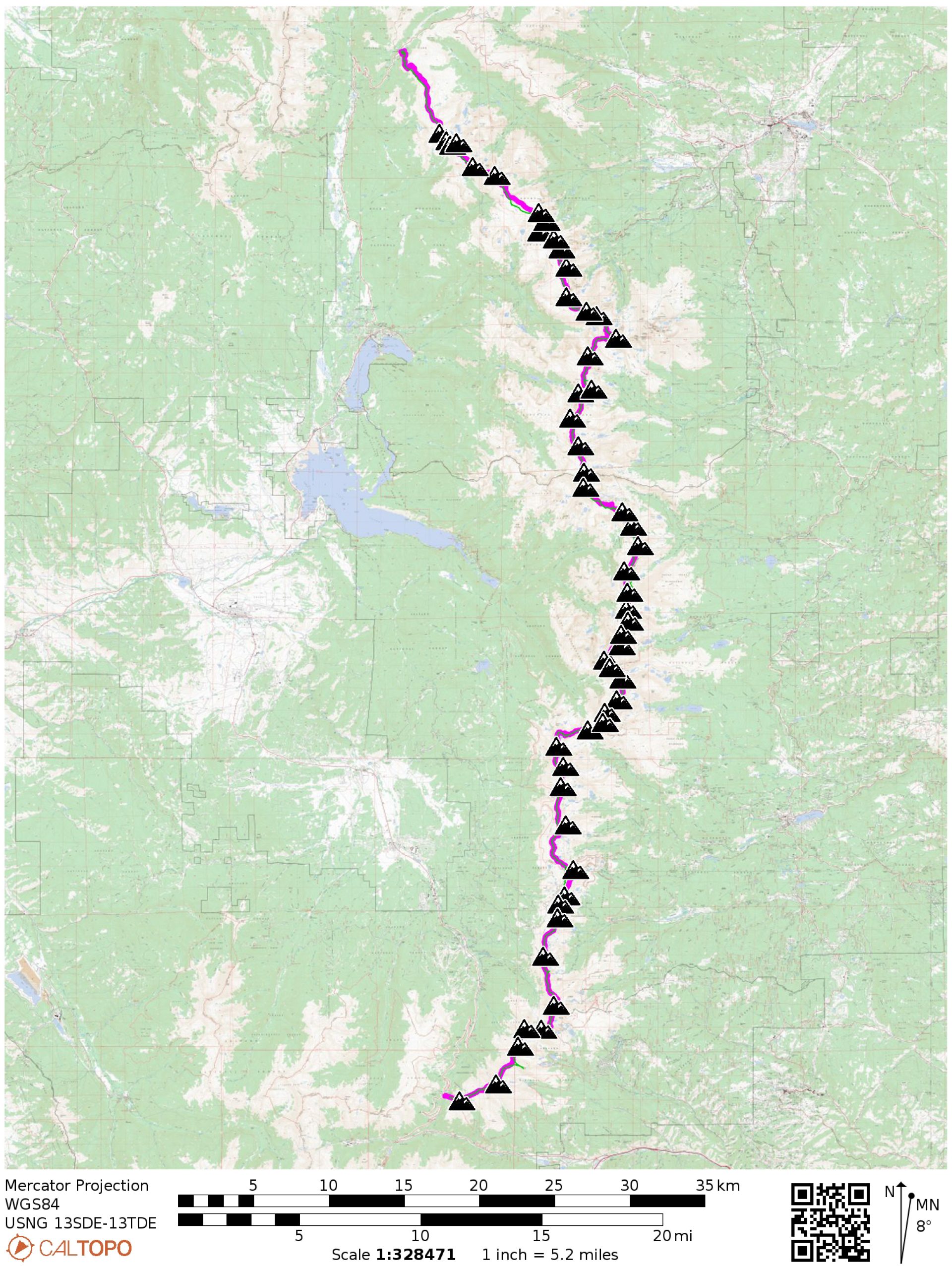
Summited Peaks
- Named peaks in black have 300′ or more rise and a half a mile of isolation
- Named peaks in gray have less than 300′ of rise and/or less than a half a mile of isolation.
- “bonus” peaks are peaks summited, but not located directly on the Continental Divide.
- Mount Ida, 12,900′
- Chief Cheley Peak, 12,804′
- 12820, 12,820′
- Cracktop, 12,780′ (bonus)
- “Mount Eleanor”, 12,380′
- Sprague Mountain, 12,713′
- Knobtop Mountain, 12,331′
- Notchtop Mountain, 12,129′
- Ptarmigan Point, 12,363′
- Flattop Mountain, 12,324′
- Hallett Peak, 12,713′
- Otis Peak,12,486′
- Taylor Peak, 13,153′
- Powell Peak, 13,208′
- McHenrys Peak, 13,327′
- Chiefs Head Peak, 13,579′
- Mount Alice, 13,310′
- Tanima Peak, 12,420′
- The Cleaver, 12,220′
- Isolation Peak, 13,118′
- Ouzel Peak, 12,716′
- Ogalalla Peak,13,138′
- “Ooh La La!” 12,945′
- 12277, 12,277′
- “Red Deer Mountain”, 12,391′
- Sawtooth Mountain, 12,304′ (bonus)
- “Algonquin”, 12,574′
- Paiute Peak, 13,088′
- Mount Toll, 12,979′
- Pawnee Peak, 12,943′
- “Pawshoni”, 12,878′
- Shoshoni Peak, 12,967′
- Apache Peak, 13,441′
- Navajo Peak, 13,409′
- Arikaree Peak, 13,150′
- “Deshawa”, 12,820′
- North Arapaho Peak, 13,502′
- South Arapaho Peak, 13,397′ (bonus)
- “Quarter to 5 Peak”, 12,300′
- Mount Neva, 12,814′
- Mount Jasper, 12,923′
- 12660, 12,660′
- “Skyscraper Peak”, 12,383′ (bonus)
- “Hell Hill”, 12,020′
- “Beacon Peak”, 12,072′
- “Frosty Mountain”, 11,980′
- “Sprint Peak”, 12,110′
- “Heartbeat Peak”, 12,251′
- James Peak, 13,294′
- Mount Bancroft, 13,250′
- Parry Peak, 13,391′
- Mount Eva, 13,130′
- Mount Flora, 13,146′
- Colorado Mines Peak, 12,493′
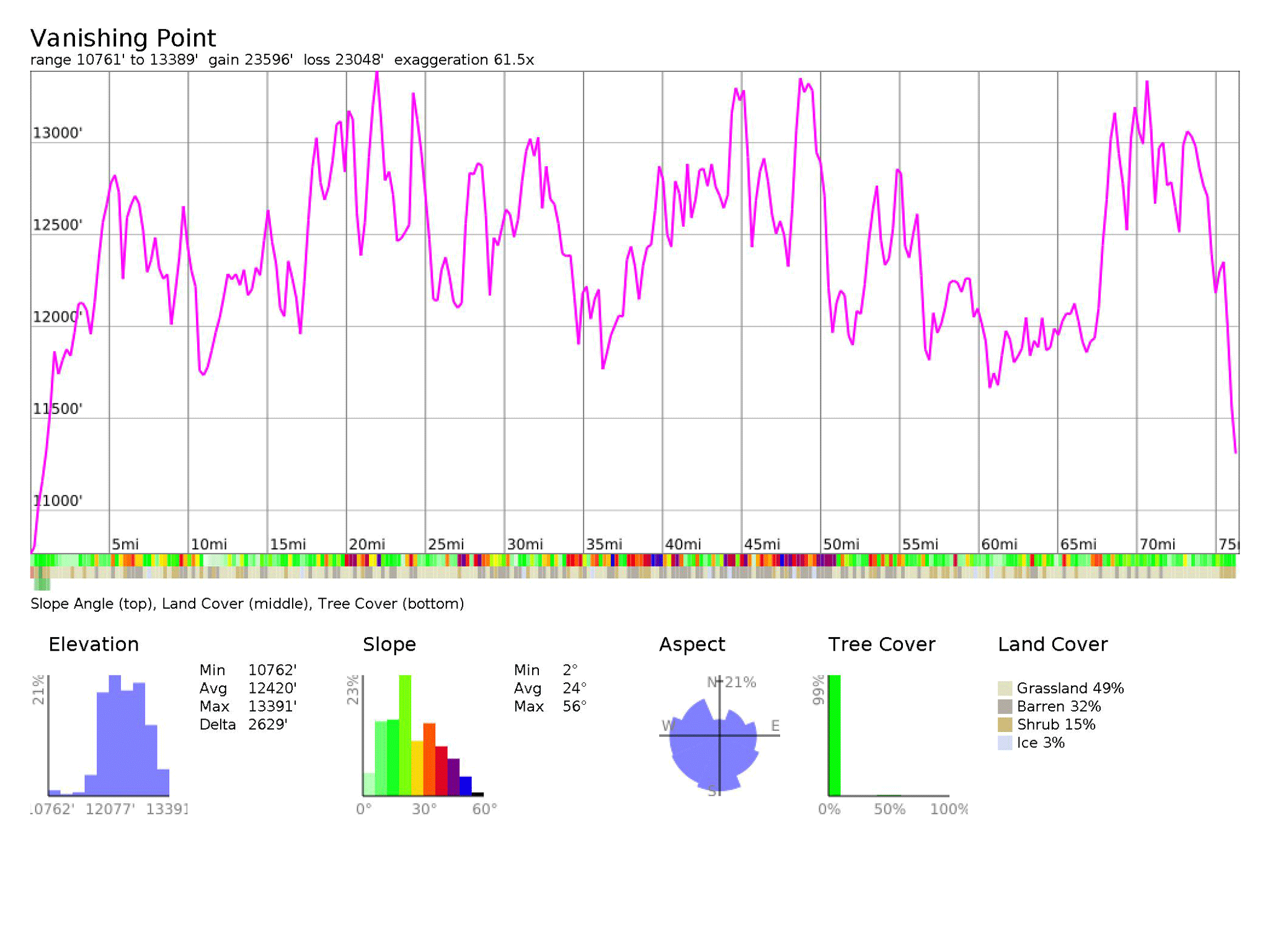
The goal of the traverse was to summit all named points and peaks found on the Continental Divide between these two passes. I used the listsofjohn.com site for the list of names peaks and points to summit. It’s not realistic to traverse right on the ridgeline at its highest point for the entirety of the trip, so some unnamed towers were traversed below. It’s accepted that one can drop down off the ridge for a traverse like this to find shelter or water, but one needs to climb back up at the point they dropped down, before continuing the traverse.
I myself never dropped down off the ridge proper during my trip, except between Navajo and Arikaree. This more than likely is what the vast majority of people need to do when linking these two peaks together . I don’t know if it’s even reasonable to follow the ridge between these two peaks directly – the terrain looks particularly gnarly, including having to climb up and rappel off a series of steep towers and negotiate the cleft of a high glacier.
Cruxes
Unlike other long, on-trail mountainous routes or off-trail high routes, a ridge traverse can require taking on technical sections head on. Cruxes here at between Class 4 and Low Class 5. Expect the rest of the route to be trail-less, between Class 2 and Class 3+:
- McHenrys Notch and subsequent traverse to Stone Man Pass
- The Cleaver to Isolation Peak
- North Ridge of Paiute Peak
- North Ridge/Face of Mount Toll
- Ridge between Shoshoni Peak and Apache Peak
- North Face, Navajo Peak
- North Ridge of Arikaree Peak
- North Ridge of Deshawa
- North Ridge of North Arapaho and traverse to South Arapaho
- North Ridge of Mt. Neva
Related Routes
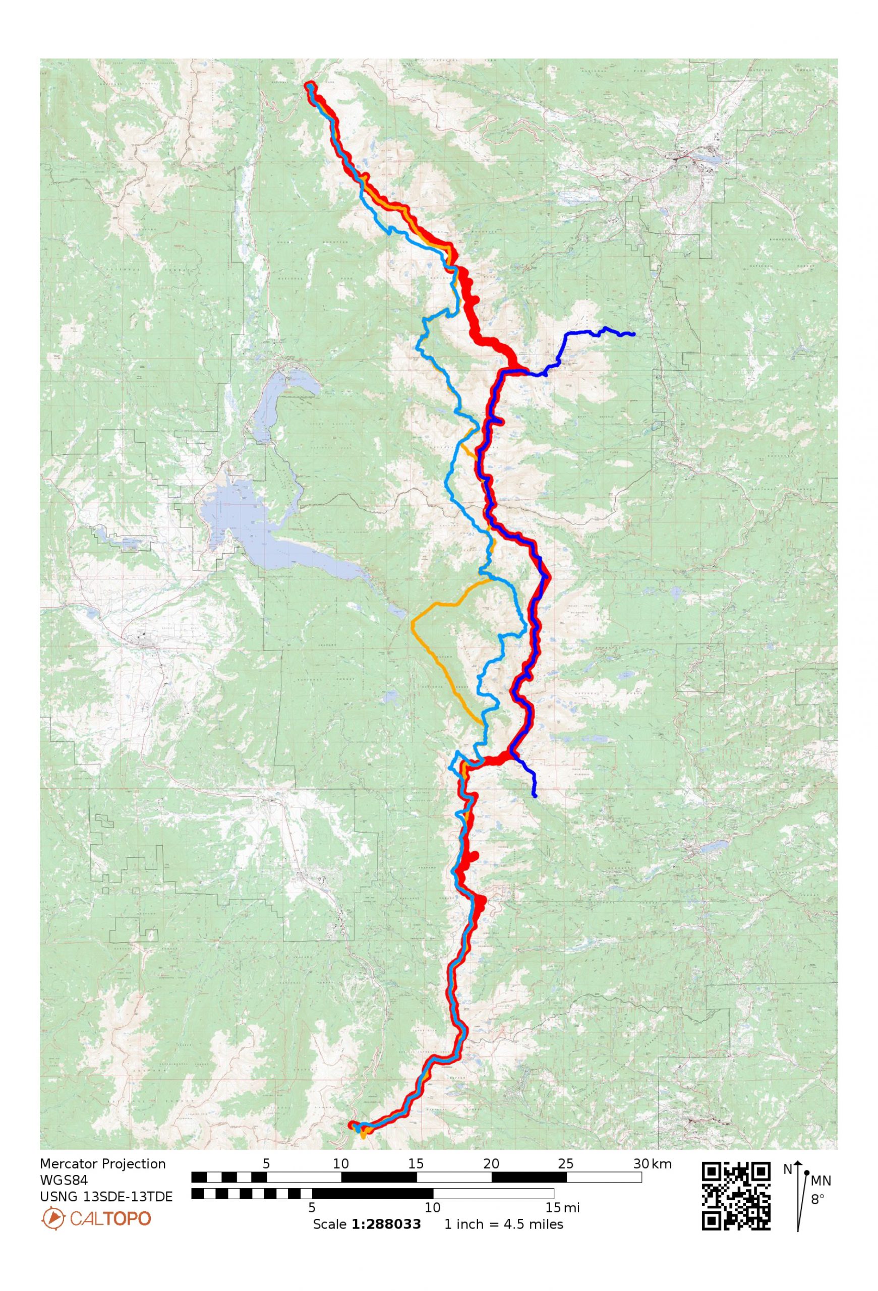
There are many routes and trips that have started/ended at Milner/Berthoud. The route described here specifically stays on the ridgeline between the two passes and summits all the named points and peaks found on that ridge.
Some other related routes are:
L.A. Freeway
A sister route. Starting at the East Longs Peak TH, one takes the Cables route up Longs Peak, traverses to Pagoda Peak, then to Chiefs Head, where one will be on the Continental Divide. This is taken south to South Arapaho Peak, where one drops down to the Fourth of July TH. You’ll miss the McHenrys Peak crux, but will add Cables on Longs Peak, and the traverse to Chiefs Head from Pagoda. Mileage is about half, but this route is the most similar when it comes to technical difficulty and the spirit of sticking to the ridge.
Skurka’s Pfiffner Traverse
A well-documented high route. This route will traverse over the Divide, but mostly stays well below the ridgeline. Think of it a, “path of best experience” route, rather than the, “path of most resistance”. All the technical cruxes of the ridgeline are avoided and only one Class 3 traverse over the ridge will need to be negotiated.
Oveson’s “Fast” Pfiffner Traverse
Another route that wanders between Milner and Berthoud Pass, similar to Skurka’s route, but more peaks are summited. Predates Skurka’s published route.
Tommy Caldwell, Alex Honnold CUDL Route
This project shares a few miles with the Vanishing Point route – mostly from Mt. Alice in the south to around Flattop Mountain to the north. But the CUDL route is really a very different beast, as it climbs various classic moderate routes that start below, then top out on the Continental Divide. Except for Mt. Alice, the majority of this project is found around the edges of the extended Glacier Gorge and could really be seen as a variation of “A Walk in the Park” in a very ultimate sense.
Pfiffner?
“Pfiffner” has become a term for it seems any route between Milner and Berthoud Pass. This has lead to much confusion, and I intentionally decided to not use it as an appellation.
More
Chris put up a great video about his experience on the route, as well as his own trip report.
Updates
- 1/6/21 – Added an interactive map!
- 1/7/21 – Added a section about similar routes