Like this? Follow me:
Centennials Summited (18):
- Mt. Buckskin
- Mt. Democrat
- Mt. Cameron
- Mt. Lincoln
- Mt. Bross
- Mt. Silverheels
- Quandary Peak
- Fletcher Peak
- Atlantic Peak
- Pacific Peak
- Crystal Peak
- Grays Peak
- Torreys Peak
- Mt. Edwards
- Mt. Bierstadt
- Mt. Evans
- Mount Meeker
- Longs Peak
Total Mileage:
- Bike Bike: 204.5 miles, 18,606′ elevation gained
- By Foot: 74.1 miles, 33,825′ elevation gained
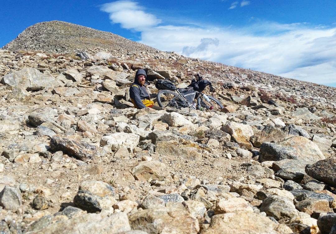
Day #56 (September 11th, 2017): Buckskin/Democrat/Clinton/Cameron/Lincoln/Bross
Huge day. Unfortunately, my GPS didn’t record the track, which except for a small part of the San Luis Trifeca and my time in the Weminuche, was the only time my GPS acted up in 60 days. So not too bad of a performance, I guess.
Six peaks in a day makes for a fairly long and committing route. Things like checking up on weather while you’re up high start needing major attention.
And for me, I hit pretty bad weather, which got electrical once I got near Cameron. Ducked under some overhanging cliffs near the route a few times to try to avoid the worst of it, while taking micro naps.
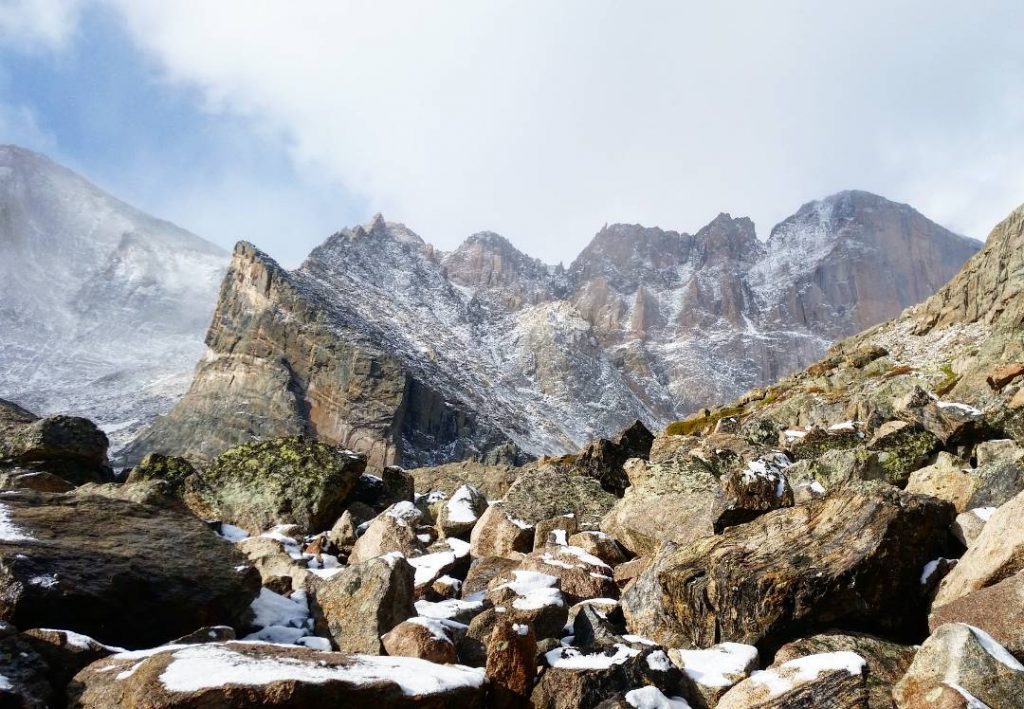
Adding Clinton to DeCaLiBron really changes the feeling of this day significantly, as the route from Buckskin to Democrat, then further on to Clinton has some solid Class 3 sections to the route that are quite fun while also being a stark difference to the easy-going nature of Cameron, Democrat, and Bross.
I was happy to get this recon of Buckskin/Democrat/Clinton when I took on the entire Mosquito/Tenmile ridgeline the following year.
View this post on Instagram
The DeCaLiBron loop, plus the two Centennials was a strange day. This is from the summit of Clinton, which gives you a bird’s eye view of the enormous molybdenum mine that’s both tearing down Bartlett Mountain, as well as digging a huge pit beside it. The rest of the day was dodging thunder snow showers and hiding out under cliffs. My beard stood straight up from the electrical activity in the air! Dangerous. Nothing in town was open, so I ate dinner out of the venerable Al-Mart general store. Rain on and off. Could be worse. 92 peaks down.
Later: Kite Lake TH to Hoosier Pass
Being Sunday, there really just wasn’t much open in old Alma, so I crashed out at the venerable Al-Mart (sort of a requirement if touring through Alma) after BuDeCliCaLiBron, figuring out just what to do, as I was tired and it was getting late.
I was looking at the prospect up riding the highway up to Hoosier Pass to get me in a good place to start on Silverheels in the morning. Decided that riding up Hoosier Pass at night was risky but doable to do, and bivvyed up on the pass itself. More beer found!
Perhaps in the future, I would take one of the side roads to be found just west of the highway itself to minimize how much potentially busy/dangerous highway riding I would need to do. This stretch of road is on the TransAmerican Trail route, so it’s not like cyclists aren’t ever seen on it.
Day #57 (September 12th, 2017): Mt. Silverheels
This was an early, and pretty challenging summit to do, as I was well-spent from the effort of this entire trip. The summit was also very cold. Getting to the summit just felt as if I was absent-mindlessly plodding along. I was hoping things would turn for the better, as I had a Hell of a day planned.
View this post on Instagram
Hey, just share a moment with me on Mt. Silverheels
Later: Hoosier Pass to McCullough Gultch TH
A quick downhill ride off from the summit of Hoosier Pass, and a quick ride up the gravel road to the start of McCullough Gulch TH. I decided on this trailhead as I wanted to do Quandary, and the rest of its satellites from the trailhead, and needed to make the start/end point as close as possible.
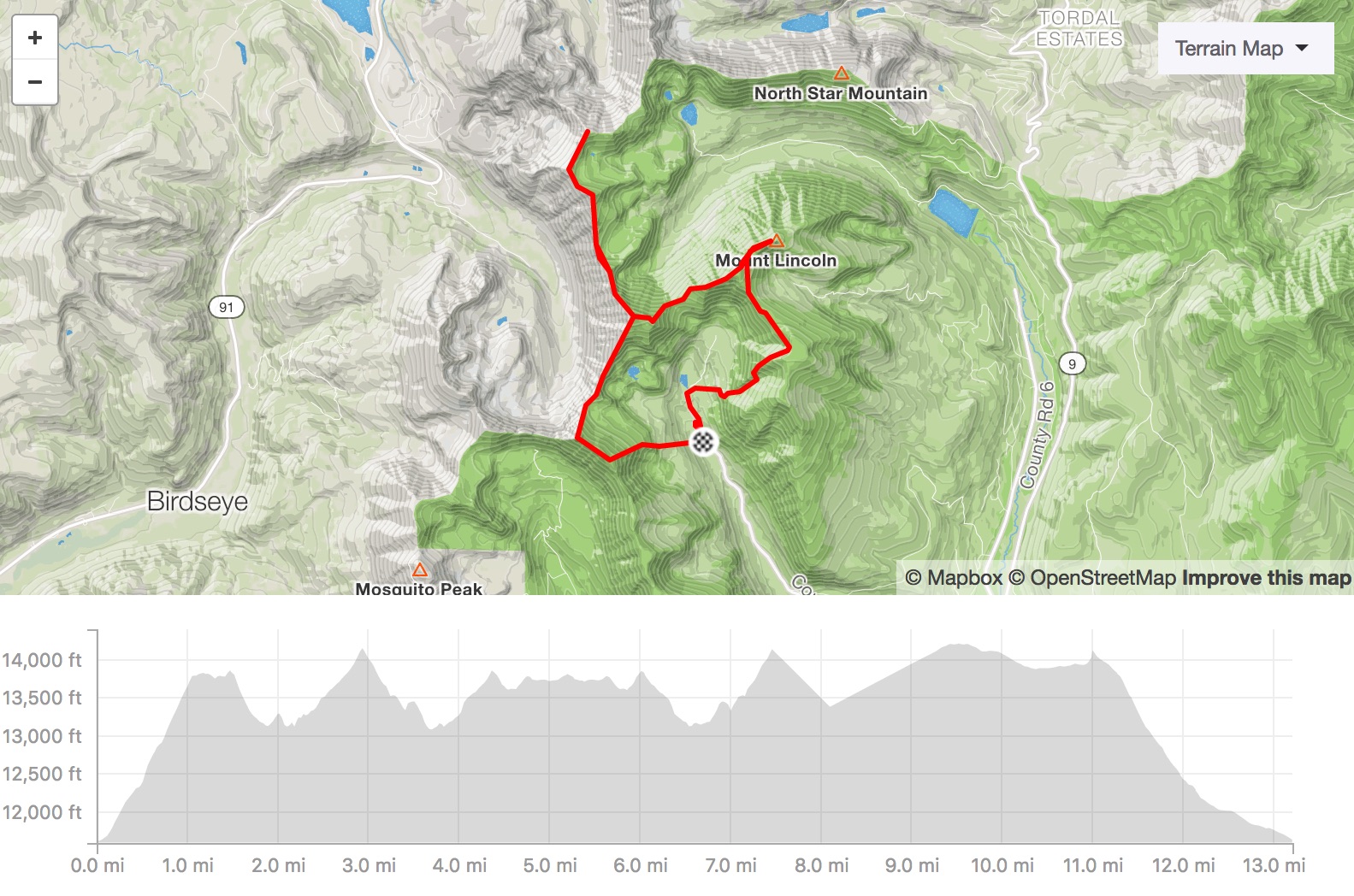
Later: Quandary/Fletcher/Atlantic/Pacific/Crystal
Huge day – even subtracting doing Silverheels in the morning!
Doing Quandary’s West Ridge from McCullough Gulch really is a good way to go about things when there’s little/no snow to take the Blue Lakes approach to the West Ridge. The trail up the Quandary/Fletcher saddle doesn’t seem to be at all maintained, but it’s a good one – and much easier than I anticipated. A metric ton of trail traffic on McCullough Gulch – it may be up there as one of the busiest trails in Summit County that (usually) isn’t taken to a summit – the other is probably Mohawk Lakes trail.
West Ridge of Quandary was quite fun – my first time on it felt a little over and above my skill level. Linking Fletcher by going back down the West Ridge is somewhat convenient, but that’s sort of where the ease of this route ends.
The direct ridgeline from Fletcher to Atlantic is a monster and I wasn’t sure it was wise to onsight link it in my destroyed state of physical and mental health. The other option is to drop back down off the ridgeline and take a cross-country route across the basin, then back up Atlantic.
Like a lot of decisions of this Tour, I had to weigh the, quicker-yet-more-technical with, longer-but-easier. Longer-but-easier won out this time, and I’m pretty glad I decided against the direct ridgeline. In 2018, when I finally did take on the ridge, I thought it to be one of the most dangerous things I’ve ever done alone in the mountains. Not to be taken lightly – loose, complicated, and quite long.
Once Atlantic is summited, you still have to summit Pacific, then Crystal, and then hike the long slog back to McCullough Gulch. Atlantic/Pacific/Crystal is mostly Class 2 ridge walking. I shortcutted a bit down back into the Mohawk Lakes Basin, but it soon got dark. I’ve never been that high up in this basin, and I found basically a swamp worthy of a Moose Heaven. It only got harder to navigate, as the glacier-polished rocks started to pop up, along with dense willows. Just a nightmare to handle while so tired.
But eventually found Mohawk Lakes trail that then hooked up to the Wheeler Trail, and I knew that would get my back to McCullough Gulch TH. Took a brief nap in all of that. Hadn’t seen anyone since the summit of Quandary.
I passed right out at the McCullough Gulch TH. Not the greatest place to do so, as it seems many a human had used my patch (or close to it) to deal with their bathroom needs. So ended the second six peaks summited in a day in a row.

98 peaks down. 98! On top of Crystal Peak closing the last of this project’s grand enchainments. The sun is setting, and I look just a little dazed. 3:00am start to stumble up Silverheels, a quick nap back on Hoosier Pass, then off to McCollough Gulch to summit Quandary from the West Ridge route, then off to Fletcher, Atlantic, Pacific, and finally here on Crystal Peak.
Bomb down the southeast face of Crystal – trying not to get cliffed out, then into the basin to navigate the glacier smooth slabs and wetlands of the Mohawk Lakes area in the dark. Thunderstorms well in the distance flashed brilliantly in the sky, their violent light show reflected in the perfect mirror surfaces around me. And I in this enormous basin all alone. Not even a high altitude moose to chase me out. 10 minute wink at the Wheeler Trail junction, and a sleepy stumble back to the bike at the trailhead at 12:30am. The Tenmile/Mosquito range has been closed down!
Front Range: I’M COMING FOR YOU
Day #58 (September 13th, 2017): McCullough Gulch to Peru Creek
Aprés marathon day, I was happy to limp into Breckenridge, then out of Summit County itself to finish up the Front Range. Peru Creek is an interesting way to access Grays/Torreys/Edwards, and I was all alone in the basin, shivering the night away.
From Peru Creek, I would cross the Continental Divide using 13,000+’ Argentine Pass, rather than the paved/busy 11,900′ Loveland Pass.
Later: Grays/Edwards/Torreys
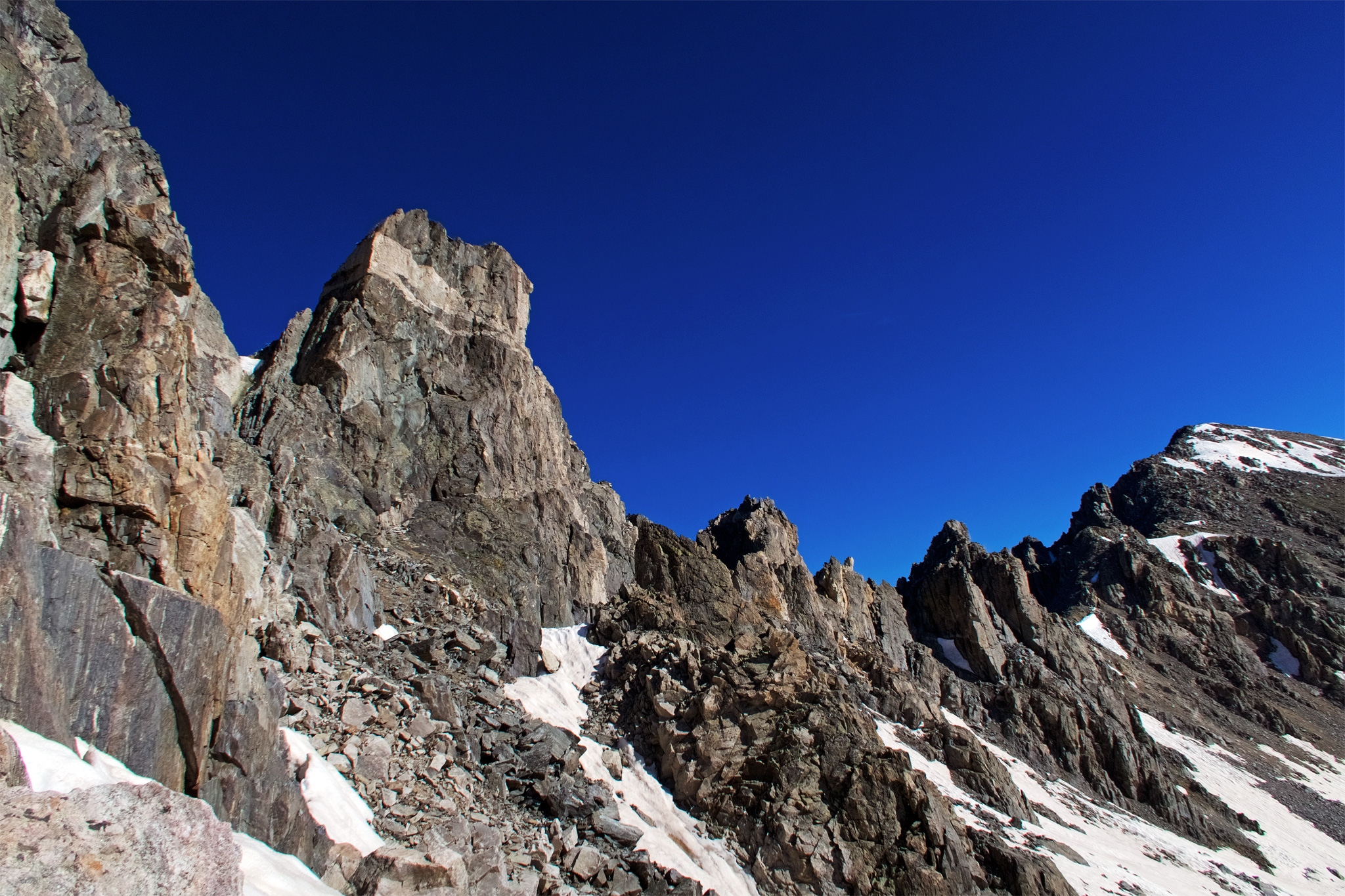
Not to waste any time, once I got to Peru Creek, it was time to summit Grays/Edwards/Torreys. Ooof. What else can I say? Zombie walking up the southest ridge of Grays Peak, then taking on Mt. Edwards (happy to have done that before), then finally a little trip to Torreys. I was again quite alone, however unbelievable that must be to hear for some, as this is one of the most popular peaks in Colorado.
Peru Creek has little water I really trust – the main creek stains the rocks in it white, which makes me think twice. Lots of mining activity. Ugh – best to bring your own water if I’m being honest.
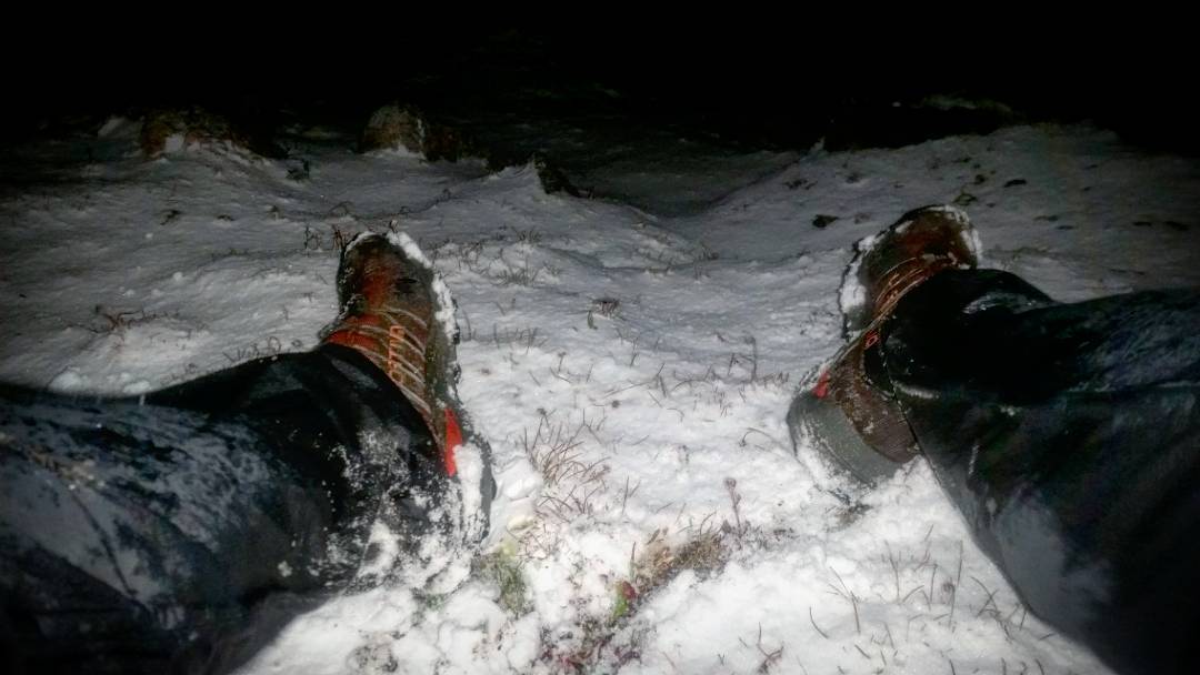
Day #59 (September 14th, 2017): Argentine Pass to Guanella Pass
Shivered the night away – getting late in the season! Mostly stumbled up Argentine Pass pushing the bike ahead of me. Was in a pretty terrible mood. Once up and over, things were a bit better as its mostly a quick descent to Guanella Pass Road. Shortly after sumitting the pass though, I was convinced I had a slow leak in my back wheel, which turned out not to be the case. I was just so confused on what was going on in the world.
Once on the road itself, I stashed most of my gear in the trees, and road up to essentially the summit of Guanella Pass to hike Bierdstad/Evans. Rough shape.
Later: Bierdstad/Evans
Another late start after a meaty bikeride. Your can’t get any easier than Bierdstad, but the weather broke on me even before I got to the summit, and I was snowed upon, which made the Class 3 traverse over the Sawtooth all that more interesting.
Got snowed on again trying to get to Evans, which made even summiting almost impossible. I just couldn’t see where I was going! I literally scrambled up some rocks I thought were somewhere near the summit itself, only to find a 1,000 feet of air on the other side – the North Face of Mt. Evans! Glad I didn’t slip off.
Got the Hell outta there, and once I got off the ridgeline itself, the snow did let up. I then had to deal with soaking wet willows hiking down Evans. Wet willows and unrelenting mud, I should say. It was a serious bummer, but I knew in my heart that this would be the last clump of willows I’d have to deal with on this trip.
These willows man, they never give you an easy pass.
And then, there were only two peaks left. On my 14er tour, people often asked me what the hardest peak was. I replied, Bierstadt!, which made people smirk and crinkle their forehead at my reply. But it was true – I was so tired it felt almost impossible to get up its gentle slopes. This year it’s Mt. Evans, where Winter finally caught up to me and dumped enough snow to accumulate on the ground! I’m not really wearing a whole lot of clothing- started the hike up shirtless!, so facing a squall of blowing snow and 0 viz. at 13,000’+ at night was somewhat an interesting challenge of staying alive, and maybe even tagging the summit. No puffy… no gloves, just my UL running jacket and pants, some base layers. With my failing headtorch, I scampered up to a highpoint, until the terrain dropped below me. What the? I’ve been on this summit >dozen times before, but didn’t realized I was on it again now, staring into the deep abyss of Evans’s east face! My earphone speakers were buzzing loudly, they weren’t in my ears, or even plugged into anything – electricity in the air! I tagged the other boulder that may/may not be the summit just in case (you’d know what I mean if you’ve been up there) and made my way down the west gully to face death by a thousand willows , which of course now were sopping wet. Finally, at the trailhead I had to get down the pass at midnight, cold, wet, exhausted, out of food – all those and more. I guess that’s a story for another time! Onwards to /Meeker/Longs, after recouping a bit near Idaho Springs, a “recovery” ride to the E. Longs Peak TH, and a proper alpine start tomorrow to close out this Mother.
Day #60 (September 15th, 2017): Guanella Pass -> E. Longs Peak TH
Having brought only the gear I needed to do the two mountains, I still had to get back down to my bike! I was soaked, and it was getting very cold. I wrapped myself in a cheap, plastic poncho I bought all the way back in Silverton, as well as a emergency Mylar blanket and just took it slow to lessen the wind chill I created riding downhill. Reunited with my gear, and made a crappy bivy off the road. Terrible night.
The next day, I took basically the entire day to get close to Longs Peak/Mt. Meeker. I got to Nederland before the snow started flying again, and I holed up in the grocery store for a while. I had lost my bike gloves, so had to buy some questionable gloves in the store to make the rest of the Tour happen.
Camping in the Park can’t be done without a permit, so I slept on a patch of NF land well outside, but right next to the highway.
The morning after, I road the 10 or so miles to the trailhead proper, to take on the last two peaks. The weather looked absolutely terrible.
Day #61 (September 16th, 2017): Mt. Meeker, Longs Peak
Last day of the Tour! And, one of the hardest, for sure. It was basically snowing at the trailhead, and I could tell even from down low that the wind was blowing at its worst. I was determined to summit, though (what else to do?). I kept passing people with sad, forlorned looks of defeat, wondering just what I thought I was going to be doing up there.
Despite getting absolutely assaulted by the snow, wind, and spindrift – literally almost being blown off the mountains at one point, I successfully summited Meeker, than Longs (up Loft, down Keyhole). On the summit, I wept, then made my way down. At the Boulder Field, I slipped on some ice and managed to sprain my right ankle – my worst injury of the entire Tour, and limped the rest of the way back to the trailhead.


Longs Peak TH -> Home
The closest I got to a victory lap. I’ve done this ride well over a dozen times, so no surprises. Met my housemates and friends in front of the city limits sign, completing the loop I started two months prior. At a bit of pizza, drank a beer, then rolled slowly the mile or so, home. Tour completed!

Finish line last night! I woke that morning up after a long nap not knowing where I was, or what I needed to do. When it finally came to me who I was, what I was doing, and where I had to go, I didn’t honestly want to summit Meeker/Longs -I was so mentally exhausted and the conditions were horrible. But, got it done, made it back to Boulder, and finished the Tour of The Highest Hundred! I’m still drained, and nursing a foot injury, but I’ll share more of my last day – and of my entire Tour, in the future. Thanks to everyone!
- Week #1: Boulder – Sierra Blanca Group
- Week #2: Crestone Group – Lake City
- Week #3: Cinnamon Pass – Molas Pass
- Week #4: Weminuche + Wilsons
- Week #5: Telluride – Antero
- Week #6: Antero – Mount of the Holy Cross TH
- Week #7: Holy Cross – Capitol Group
- Week #8: Castle Group – Grizzly Peak (A)
- Week #9: Democrat Group – Finish!
