Like this? Follow me:
Stats (approx.):
- 32 miles
- 10,000’+ elevation
Total time:
- 1 day, 2hr, 30min
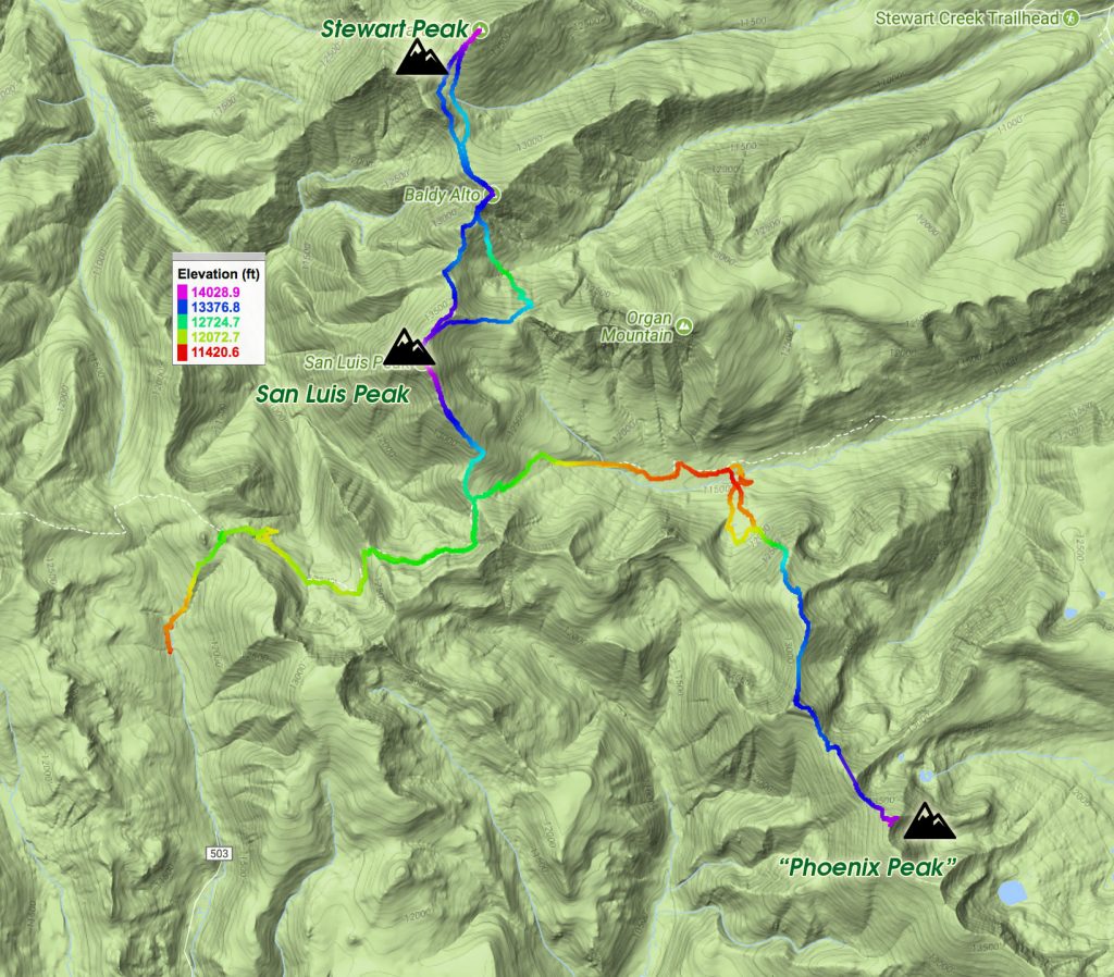
Three Centennials Summited:
- “Phoenix Peak”
- San Luis
- Stewart Peak
I questioned framing this leg of my Tour of the Highest Hundred as a, “Fastpack from Hell”, as the numbers really don’t compare to the Crestones, Sierra Blanca – let alone the mighty Weminuche. A motivated person, starting early with fine weather, could potentially do this course between sunrise and sundown. Unfortunately, that wasn’t my situation, when I left my bike far above Creede, CO in the summer of 2017.
The San Luis group of mountains: “Phoenix”, San Luis itself, and Stewart Peak are some of the shyer Centennials and the first group I approached when coming from the Sangres in the east. Like many of the transitions between sub-ranges, the ride to the area was quite long. From the town of Crestone, it’s around 120 miles to the Willow Creek trailhead, with 4,000+ feet of elevation gain – the majority of that vert. on the last 10 miles of 4WD Track from Creede, CO to the trailhead.
I left Crestone late in the morning, having hiked out from the Cottonwood Creek trailhead earlier that same morning, finishing up the Crestone Centennial enchainment. The ride across the San Luis Valley was for the most part a good time – a little too much traffic/lack of shoulder on Highway 17 en route to Hooper, CO (mandatory stop for breakfast if you get there early enough!), but after that stretch, I diverted onto calm and quiet backroads until Del Norte, CO. (Starting at Hooper, take Lane 11 N west, south on North Road 4 E, west on East Road 9N). This crossing of the San Luis Valley would be the lowest and flattest stretch of cycling I would see all tour until my very last ride Lyons, CO to the finish in North Boulder.
Del Norte is a small town at the edge of the San Juans. It holds a special spot for me as it is on route of the Tour Divide/GDMBR that I’ve done twice (as well passing through when training for said race). There’s not too much to the town, but I was surprised there seemed to be more growth in the past few years than I would have ever guessed. Like – there’s now a brewery!
The day was getting long, but I wanted to get going after my resupply in Del Norte. Fortunately, from my experience on the Tour Divide, I knew there was a gravel road back way west towards Alpine, so I could keep riding, and stay off of the highway after dark. I diverted my riding onto the Tour Divide route heading north (County Rd 15) then leaving it to further follow the same road west, paralleling the highway (the GDMBR/Tour Divide heads up North after navigating through the local airport). It was a fine time to try out my dynamo’d powered light, which worked fairly well, after a small adjustment of the wire connectors from the hub, to my light, at dusk.
Alpine wasn’t too difficult to reach, and I crashed (sleep-wise) right outside of town on some BLM land. In the morning, I grabbed some stuff for breakfast in South Fork, and started on the road to Creede. This stretch of road between the two towns is narrow, winding, and can be busy, so I wanted to try to beat as much traffic as I could. Quite pretty though, as you once again enter into the high country of Colorado. A great study in contrasts.
Once in Creede, I found the supermarket, and once again loaded up on my favorite things (FOOD), and took my time to reach Willow Creek TH. The route is a busy one for 4WD standards, as there are many historical mining points of interests along the way which attract tourists. Willow Creek trailhead is also a less than popular extraction point for Colorado and Continental Divide thru-hikers, and some of them get a lucky ride the 10 miles back to town by a four wheel drive enthusiast.
The weather up to this point had been clear, but it was destined to turn for the worst. Up on Willow Creek, I free-locked my bike next to a tree, placed a, “Hey don’t take my bike!” magical plastic laminated piece of paper on the handlebars, threw my food bag into a tree, and started my way hiking up the small rise. This was my third multi-day trip in a row and I had just finished my third 100+ mile bike segment.
I was starting to feel the tour.
On the other side of the rise, you’ll reach the boundary of the La Garita Wilderness, and soon after that, hook up with the CDT/Colorado Trail. The route to San Luis is a straightforward one: follow the trail east until the trail junction to San Luis; hike up San Luis! Tacking on the two other Centennials does complicate things… “Phoenix Peak” in particular isn’t really all that close to San Luis, and I questioned myself during my planning phase if I should even do it on the same hike in. In the end, I thought, “what the hell” – if anything, it would save some loss/gain of elevation, riding to only one trailhead, instead of two.
It didn’t take long on the trail to pass thru hikers that were scrambling, trying to take cover – or even get a ride to town before the next storm blew in. Unfortunately, I couldn’t help much – I had never been on this stretch of trail to the west to share beta on campsites, and who knew if anyone would be driving up soon to grab them – a 10 mile hike down to town seemed less than ideal.
I decided to go for “Phoenix” first, as San Luis is on the way to Stewart, and you’ll have to ascend San Luis twice to finish the two off. That seemed less than ideal in poor weather. I passed the junction to San Luis and kept going towards “Phoenix Peak”.
Judging from the topo, the route to “Phoenix Peak” started not too far away from the trail, past a forested area where, after you gain a ridge, you then follow said ridge over a few highpoints. What the topo map didn’t really tell me is that there’s a bloody swamp between the trail and the ridgeline which needs to be crossed! Swampy areas in Colorado at such elevation aren’t so common – you really have to search them out, and I had found me a doozy.
With considerable effort, I made my way through the wetlands, the thick forest choked with ferns hiding the never ending downed trees, and the worrying signs that a large mammal had recently torn asunder through the area. I wasn’t much afraid of bumping into a deer or a bear, but I was deathly afraid of meeting face to face with a moose in close quarters, and I was in moose heaven.
I didn’t really know if this way would go at all, but I wagered I’d be able to somehow climb up the north face of some unnamed peak to gain the ridge that led to “Phoenix Peak”. Some of the mountain faces in the area look a bit gnarly, like the south face of nearby Organ Mountain, but what else could I do, but make the call when I got there?
Finally, somehow, I did get “there”, tearing some of my rain gear in the process doin’ the splits trying to surmount some particularly large diameter fallen logs, and absolutely drenching myself falling face first into everything in my path. Complete and utter comedy.
Right before gaining the ridge by climbing the steep north face in front of me, I cached most of my gear to make my tag of “Phoenix Peak” a little easier. Clouds were quickly descending from above, and they’d remain that way until I got out of the area. It began to lightly rain – which I realized was mostly just me being surrounded by the cloud cover. I was thankful I had a GPS track to follow, because my visibility was getting pretty terrible. With the quickly coming of night, it was only going to get worse.
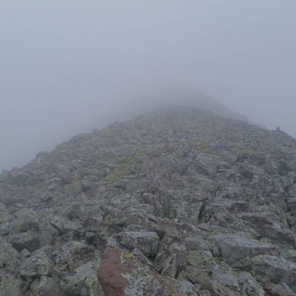
Although not technically hard, the ridgeline was nothing but an endless field of talus. Little did I really understand, from the bottom of the face, at the end of the swamp, it’s almost three and a half miles of ridgeline to “Phoenix Peak”, which I would then have to repeat on my way back. My rock-hopping speed was about a mile an hour, during which the sky darkened with night, the clouds got ever thicker, and I got much, much colder; even more miserable. I was altogether questioning my self-professed expertise on mass linkups.
This little pastime here isn’t very fun in the rain, and I wouldn’t volunteer to do such a hike without a time goal in the back of my mind. It certainly takes a lot out of you, stoke-wise. After a few hours, I really couldn’t give a shit about “Phoenix Peak” – I didn’t even know how I would know when I summited, as there was no way to see where I was in relation to anything around me – would I think I was at a highpoint in the ridge, only to miss the real summit a few hundred meters away?!
It got to the point where I couldn’t even remember the name of the peak I was trying to summit! I was so over this night. What’s the point, you know? Like, what’s the payoff of being so cold, so wet, so alone?
I wandered on, slowly up the endless piles of slippery talus. Then, out of nowhere, a huge cairn appeared, marking the summit of “Phoenix Peak”! Someone had left a route description (the alternative route from what I foolishly just came up) tucked in the cairn with the name of the peak, which helped to job my own memory! “F*cking great”, I thought, “Time to get the F*ck down!”
I checked my GPS, but something had happened to it – it had reset itself to some sort of foreign Cyrillic Language, then flashed something about hard resetting the whole device.
NO!
I thought for sure that after the reset, it would also have had erased all the GPX tracks I needed for the entire trip, and not only would I be royally screwed in getting down in any sense of efficiency tonight, I was pretty well screwed on getting on with the entire rest of my tour! I rebooted the GPS unit in terror. When wet, the touch screen on the device is difficult to even use, so I had to fumble a bit for the GPS to even understand my pecking. I waited.
With relief, the unit didn’t erase my saved tracks – only the last few hours were found to be missing. I could deal with that.
Traveling at night inside a cloud that’s quickly shedding its moisture around you isn’t exactly choice weather conditions. The light of your head torch simply reflects back its light from the rain falling around you – you have to decide between being blinded from that or, darkness.
An hour and a half later though, and I was back at the north face, about to get off the ridgeline. One bummer about losing my track: I also lost the exact way I had ascended the face, and descent was going to be a little tricky in the rain, in a cloud, at night. I made my best guess on how to go, using the waypoint I had stored of my cache (thankfully I still had that!), as my only guiding star. That 1500 foot descent took another hour as I tried to do my best to find a safe way down that wouldn’t lead to certain cliffed-out doom.
I did a fairly terrible job, but I got down, found my cache, and made a plan on how I could possibly avoid the swamp area. I thought that if I instead hugged the mountains to the south of me, perhaps I could find a more drier route back to the Colorado. With that idea, I set off.
What I found instead wasn’t any better – probably worse. I found yet again a forest choked with greedy-for-water plants enjoying the abnormally high rainfall this year, happy to soak me whenever I slipped on the countless downed trees. Humping up and over deadfall, I scared a then-sleeping deer that had bedded down for the night, given both of us a fright. My trackless path finally led to a drainage, promising more wet fun.
I was so finished with trying to make my way through the dense bush that just following the thigh-high creek seemed the most reasonable thing to do. That is, until I fell head first completely into the creek, after losing my footing on a slippery rock. That did it in for my phone, as it never again worked 100% correctly.
I surrendered myself to the torture of this out of the ordinary quagmire I had climbed myself into, and made peace that I would spend the next few hours trying to climb out of it. My expert route finding skills led me straight to the inevitably never-ending fields of salix scouleriana; the willow. “At least there’s flowing water – to drink!”, I thought. I changed my mind when a small rivulet flowed in front of me with a dead deer resting on the willow-choked boundary. “OK: we’re not drinking anything for a while“.
Finally, I pulled myself out of the wetlands and entered back onto the trail. Still, it was raining, and the willows on the sides of the trail bowed down to greet me with a frigid splash of water at each step. It was now very late, and I had no idea where to camp, but I was looking for somewhere flat and dry, but that just wasn’t going to happen. Getting closer to the trail junction to San Luis, meant my choices were getting slim. The junction is at a high pass and not somewhere that would make a good bivy in ever degrading weather. Losing hope for anything good, I settled on an lumpy piece of land in a small clearing of the willows right off the trail. The rain was becoming heavier and well: this’ll just have to do. I was soaked, so my sleeping bag was going to get soaked. So it goes, sometimes.
I woke after a fairly miserable night of being ever so slightly chilled. The clouds hadn’t abated, and I was looking at an eleven mile out-and-back to tag San Luis and Stewart before bringing this junkshow back to town – better get a move on.
The hike up San Luis is easy, but not very enjoyable this morning. I had again stripped most of my gear to the very essentials – I didn’t even bring rain pants, or a puffy. Light means fast, I wagered. Hopefully if I kept moving, I’d keep warm, even inside the rain cloud. San Luis is only a mile and a half from the trail junction, and I made it without much bother. Stewart was really going to be the meat of the hike. These lower Centennials seemed to always pack that extra “aha!” punch, catching you off guard with their relatively low elevation, but usually trackless route, with little beta attached to them.
I had another 3 miles of ridge walking to get to Stewart, topping off a few high points along the way. I hoped the rain storm didn’t evolve into a lightning storm, or I’d be well stuffed so high and exposed. On a clear day, this would be a pleasant high tundra romp, but this wasn’t a clear day. Stewart’s summit finally came, and I could take a small sigh of relief. “Now,”, I thought, “just have to resummit a 14er!
Although there were flirtations of sunlight peaking through the clouds, the weather turned for the worse, as the rain turned into sleet, then hail. My thin running jacket and nothing but shorts just weren’t cutting it. My arms especially were freezing, and I was having trouble simply keeping them warm enough to move. The weather got worse the higher I went and I was on my way up towards 14,000’+.
I spied a trail lower in a basin, that switchback back up another ridge. In my foggy head, I believed it would all link up back to where I needed to go, that I could get a slight reprieve from the weather by dropping down for a little while, out of the storm, then climb back up – climbing things makes you warm, right?
So ostentatiously (to myself, I guess), that’s what I did! To my great relief, the route back up to San Luis went, and I again, resummited the peak, before finally, flying back down to better weather.
I collected my gear, and hiked the very pleasant CT/CDT up to my turnoff, up over the rise, and back to the bike. I laid out everything that was soggy in an attempt at drying things, and passed out myself for an hour or so. I still had the ten miles to ride back to town, but it was almost exclusively downhill.
There’s a bit of relief of tagging three more mountains in a list that spans 105, but days and nights like these were not easy on the psyche. Were all my San Juan peaks going to be just as cheerless, gloomy and well: wet?
Back in Creede, I thought the best way to cure a moody head was some pub grub, so I ordered a burger, fries, and… extra fries on the side. It was already getting late, and I had some more unskippable highway riding for hours and hours to my next destination. I started off out of town but yet another storm was brewing, this one more violent than anything I had experienced up high. I turned around and high-tailed it back to the pub I had just escaped.
The sky flashed and the local hills of Creede lit up with bolts of lightning. The streets turned into a torrents of rainfall. At least in this legitimate thunderstorm, I was stuck inside, rather than outside, but what I really wanted to do was leave.
I used the time to try to fix my ripped rain gear, and think of a plan B: if I wasn’t going to be able to leave this place, what then? Perhaps crash in the town park, or the town park’s bathroom? Find a 4WD track to the nearest National Forest to bivvy a little farther out? What if it keeps raining all night?
By 11:00pm, the storm finally receded enough that leaving town seemed somewhat plausible. I had enough supplies for a few nights – there weren’t any real resupply points until Lake City 75 miles away, and between Lake City and myself was a long detour to Thirty Mile Campground to do a 20+ mile out and back hike to tag Rio Grande Pyramid. 20+ miles, just for one peak! I couldn’t say I was really looking forward to the immediate challenge in front of me. The hits, it seems, just kept coming.
Alone, riding on the highway on a stupid bike in the middle of the night is not my first choice of things to do, but that’s the hand I was given. I was tired. Thankfully, I found a very strange campground just a few miles from town with no one in it that I crashed for a few winks – just enough time passed out without being in a sleeping bag or anything – I would would wake up naturally by being too cold to keep sleeping.
I kept on riding slowly – and cautiously on the highway towards my next destination, but again the sleep monster held me hostage, and I bailed off the side of the road for another few winks, using the same technique. Finally, the turn off for my next trailhead came up! And finally I made it to a more extended rest near 30 Mile Campground (but not at the campground itself – that would cost money!), and called it a night, at around 3:00am. It was going to be an early wake up in less than four hours for the next day, to try my best to avoid yet another round of afternoon storms.

[…] Fastpacks from Hell: The San Luis Trifecta […]
[…] Fastpacks from Hell: The San Luis Trifecta […]