
Like this? Follow me:
The Crestones! A highlight of my Highest Hundred trip – the mountains of this group are awesomely steep, the rock is solid, the scrambling: divine. This is truly a Fastpack from Hell-yeah!
Stats:
- 36.1 Miles
- 15,200’+ elevation
Total time:
- 1 day, 17hr, 28min
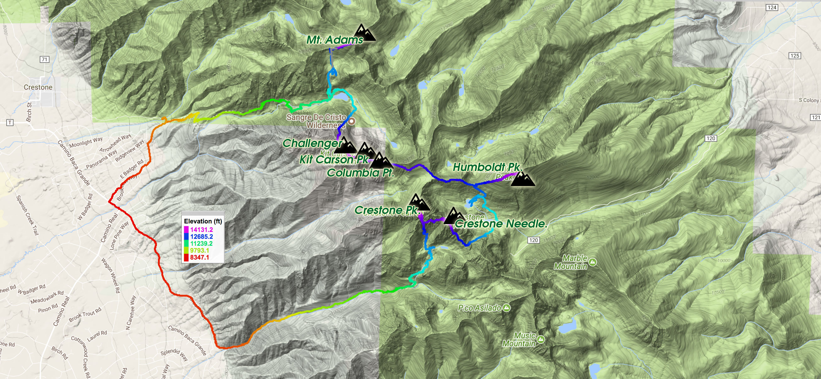
Seven Centennials summited:
- Adams
- Challenger
- Kit Carson
- Columbia Point
- Humboldt
- Crestone Needle
- Crestone Peak
Compared to the Colorado Sierra Blanca Centennial Enchainment, the Crestone Centennial Enchainment is much more straightforward. Still, strategy is much the same: summit all the mountains from just one trailhead instead of 2+ in order to save time – mostly on the bike approach. If you’re not interested in summiting Mt. Adams, it’s far more efficient to simply do the other six mountains from South Colony Lakes on the east side of the range.
In 2014, I did just that in 15 hours 37 minutes clock time, for the 15.6 miles and 8,780 elevation gain.
But, Adams is most efficiently summited from the Willow Lake Trailhead – and I wanted to approach this group from the west, rather than the east, so that I did not have to do the entire group before I went to Culebra. Willow Lake Trailhead can also give you access to Challenger Point, and from there, you can continue on to do the rest of the South Colony Lakes Centennials: Kit Carson, Columbia Point, Humboldt, Crestone Peak and Crestone Needle. To avoid having to resummit Challenger and friends, there is an option to descend an entirely different drainage: Cottonwood Creek. Cottonwood and Willow both begin in the town of Crestone, and one can simply walk the few miles of roads in Crestone itself to link them up.
I started my enchainment at around 3:00pm – fairly late from the Willow Lake Trailhead, after futzing around town (drinking a deflated cappuccino, charging batteries, etc). My goal for the day was to get to the campsites near Willow Lake and bivy for the night. I had hoped to also sneak in a quick summit of Adams, but a few late thunderstorms shut down that idea. Bad news for me. My original schedule (simplified) was:
- Day #1: Hike in, summit Adams
- Day #2 summit Challenger, Kit Carson, Columbia Point, Crestone Peak, Crestone Needle, camp at Cottonwood Lake
- Day #3: Hike out of Cottonwood Lake
Now all seven mountains would have to be summited on Day #2. If I again got stymied by weather around South Colony Lakes, I would be almost out of food, before even starting up Crestone Needle + Peak. Ugh.
I was up moving by 4:30am the next day near Willow Lake, under fairly terrible conditions: light rain and fog, after a night of thunderstorm activity. My campsite almost flooded, but the rain thankfully relented before too much damage.
The approach to the saddle of Mt. Adams was filled with many wrong turns by me – I just couldn’t see much in the dark and in the fog. Tons of willows in my way and I just couldn’t find the best way through them. This continued onto the saddle, and up the west ridge, where the climbing starts in earnest. Other than staying on the south side of the ridge when I wasn’t on the ridge proper, I don’t have too much of my beta to share. Even when the sun finally came out on my descent, I was still in a bank of fog and drizzle. The terrain was much like a kicked-back Flatiron back in Boulder, so even though the conditions weren’t ideal, it wasn’t very stressful for me – I had a lot more terrain to cover today, anyways!
Lucky for me though, all the technical scrambling and climbing are on routes I’ve done before in my Tour 14, so the unknowns could wait until I descended into Cottonwood Creek, and that at least seemed like no big deal.
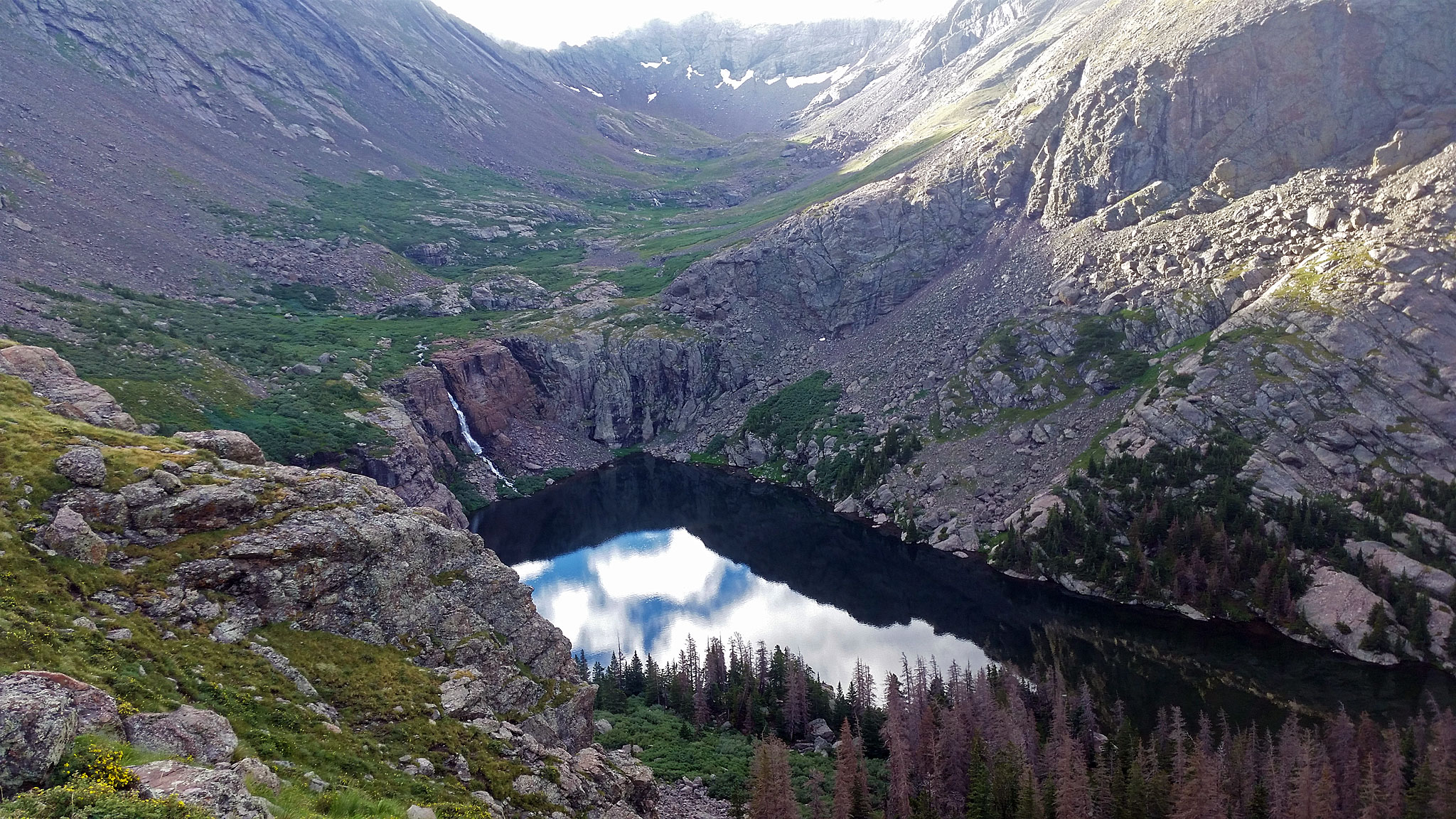
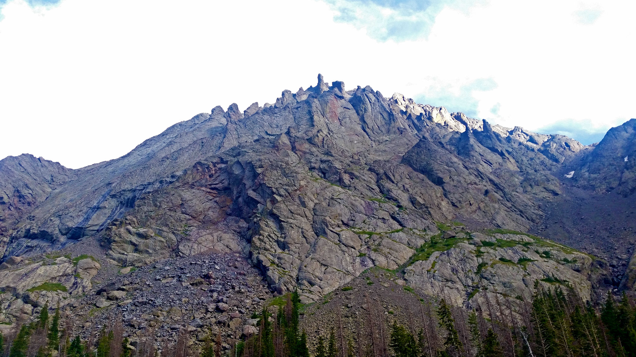
Once I got back to Willow Lake, the morning finally started to brighten up: the clouds parted, the sun shown and lucky for me, the rock started to dry out. Challenger from Willow Lake isn’t too difficult, albeit much looser than I was expecting. I was happy I wouldn’t have to descend this way, and was looking forward to the next few summits: Kit Carson and Columbia Point. Neither proved to be a problem, and I enjoyed the awesome scrambling, and incredible scenery. Fluffy clouds were visible below me, which just makes the view all the more unreal.
Now I had to make a serious choice: between the Bear’s Playground and Humboldt is an awkward and time consuming ridgeline. My initial plan was to traverse this ridgeline, tag Humboldt, then traverse back on this same ridgeline to do the Crestone Traverse from Peak to Needle. This would save me, I think, some elevation loss and would allow me to do the traverse in the direction I’ve done before, rather than in reverse.
I also had another problem: the quickly deteriorated weather. I wasn’t really looking forward to getting stuck in a violent lightning storm on any of these peaks, but I also didn’t want to get shut down at South Colony with so little food and so much more ground to cover.
Hiking up Humboldt I continued to think about my plan of attack. I left most of my gear near the trail that takes you down towards South Colony and made a quick tag of Humboldt. I was racing the weather, but also the local marmots, who would live to nibble on all my salty gear. I committed on idea to descend all the way down to South Colony Lake – I was out of water anyways. If the weather didn’t shut me down at South Colony, I could at least stop for a bit to replenish my water. So the loss of elevation I guess, was worth it in my eyes.
Lucky for me, the weather was threatening but not too much precip. fell at South Colony, so I quickly cameled up and started my hike up Broken Hand Pass. I wagered I could at least make it to the pass before the weather really started. If the weather held, I’d continue onto Crestone Needle. If not: descend to Cottonwood Lake, wait it out – maybe until the next morning. The weather did hold, so I kept going.
Starting up Crestone Needle isn’t a great thing to do in questionable weather – retreat back is dangerous on the wet rock and Class 3/4 terrain, and there’s really no sneak out of the traverse between Needle and Peak once you begin. One modicum of insurance I had with me was my complete sleep kit that I was hauling along with me. If it rained, hailed or snowed, I could make a fairly decent shelter, not only surviving, but probably being pretty comfortable for hours. Behold! The power of making this route into a Fastpack!
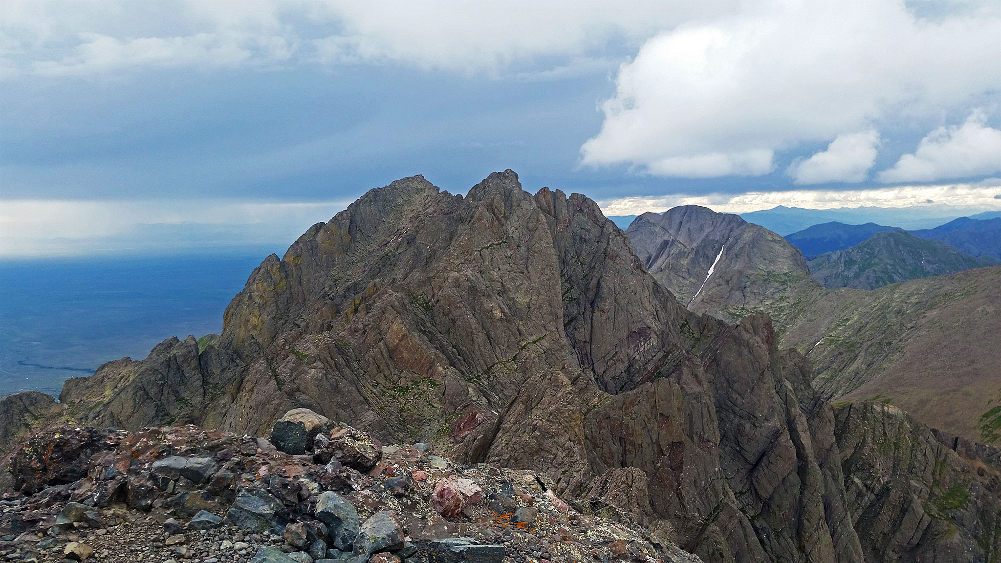
I didn’t waste too much time summiting the Needle, and started on the traverse. I’d never done the traverse this way, but knew I would first have to downclimb a fairly steep but feature-rich face of conglomerate rock. I did so, but at the bottom of the pitch, there didn’t seem to be any options to continue. Well, Hell. Maybe I went the wrong way?
I reclimbed the pitch and summited again, looking around. There’s an old metal sign that reads, “TECHNICAL ONLY” and features an illustration of a falling stick man. I avoided the terrain because this sign was blocking the way! And of course, that’s the exact way I needed to go! Quickly I descended an entirely different steep pitch of slightly easier conglomerate rock, and was on my way. Bonus pitch for me.
I fumbled around a bit more on a few key areas, as my hazy mind tried to remind itself which way to go, playing my memories in reverse. Going Needle to Peak, most of the difficulties are now downclimbs, where some people elect to rappel off. Having no rope and no gear, this can sometimes be a little more difficult. But in time, I finally found myself at the last real technical difficulties – downclimbing a 5.2 bulge, with much relief. The weather held, except for a few rain drops and threatening rumbles of thunder.
I made haste to finish the traverse, and found myself at the bottom of Crestone Peak. Without really pausing too long, I cached most of my gear, and just went for the summit of the Needle as quick as I could. It’s over 1,000 feet of Class 3/4 scrambling, but I felt super confident, and made it to the summit in around 35 minutes; descending back to my cache in 25 minutes. I beat the impending storm and completed all seven of the summits I needed to do! I was low on food, but it seemed like there was just an easy hike out via Cottonwood Creek, right?
Well,
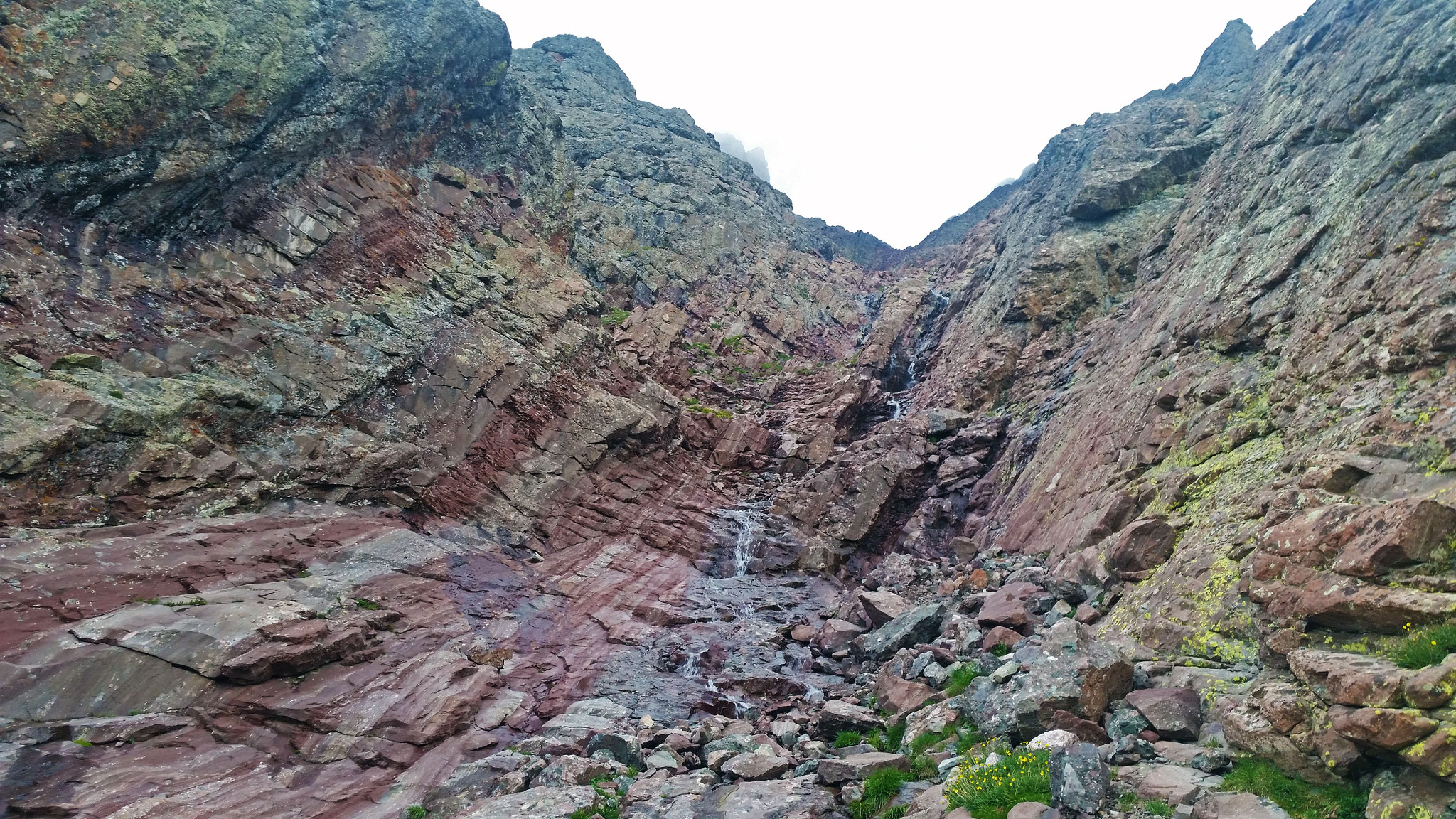
I’ve never been on a trail in Colorado that tried so sincerely to kill me. The trail itself was hard to even find, and it took me a while just to realize: there is no trail, just a series of cairns to follow. The terrain is not so easy: lots of cliffs, lakes, willows, waterfalls, and a ton of ways to get cliffed out on sketchy, slick, glacier polished boulders, which the cairns wanted desperately for you to hike onto. A nightmare.
Night had fallen, and the enormity of my day was resting heavy on my shoulders: this was not the easy descent I was hoping for. Even below treeline, a trail did not appear, except in countless small trail segments that would sometimes branch out into dead ends. I was exhausted, and only wanted to find a good patch of relatively flat and dry ground to sleep, but the terrain afforded little of those opportunities.
I settled on an overgrown patch next to some downed trees, and passed out at 10:20 pm, until 6:20 am the following morning. By now, I really had little food left.
To my relief, the trail was much easier to follow farther below and in the daylight. I was soon at the trailhead a bit before 8:00am. I passed just one person going up – the first person I talked to since Challenger Point!
Although out of food, I still needed to hike back to the Willow Lake Trailhead where my bike was kept (and hopefully, find it still there!) My route followed Cam Baca Grande for most of it, then to Bookview Way, and finally Pinecone way. At 10:00 am I was reunited with my bike, completing the route. Lucky for me, I also cached some food near my bike, so late breakfast of the most disgusting junk food then commenced as I swatted the mosquitoes around me.
In comparison to my Sierra Blanca Enchainment, the Crestone Enchainment proved to have no dramatically awful route decisions, horrible death gullies, bad route beta, or wrong turns. But similar to Sierra Blanca, this enchainment does have the problem that if you need to bail, you may be bailing out of an entirely different drainage, finding yourself on the other side of the mountain range!
If I was to do it again, I would still start at Willow Lake TH – even in the afternoon, but hike directly to the Cottonwood Lake Trailhead through town, and begin the cairned bushwhack up to Cottonwood Lake to bivy for my only overnight. This would get the boring road hiking out of the way, and allow you to ascend the Cottonwood Lake “trail”, which may be the easier direction, as you will be going slower, and may have a better time of it, trying to find the cairned route.
Then, early in the morning I would climb the Crestone Traverse – the hardest part of the entire enchainment, going from Peak to Needle – which I think is the easier direction. Getting the hardest parts out of the way before weather moves in is usually my suggestion, anyways. Then drop down to South Colony Lakes, resup. on water, tag Humboldt, Columbia Point, Kit Carson, Challenger, drop into Willow Lake and tag Adams. One suggestion to suss out is a shortcut off Kit Carson: downclimb the last pitch of The Prow, rather than the standard sneak-around.
That’s quite the day, but a pretty efficient route. From there, you would actually have an easy descent back to the Willow Lake TH, as the trail actually exists and is well-maintained. This would cut down the overnights from two down to potentially one – you could theoretically make it into town by late afternoon, grab food/resupply, then be on your way towards Del Norte.
The problem for me though traveling by bike is that it’s over 60 miles to Del Norte, using a ton of paved roads that you would have to deal with at night, and no great (legal) place to camp. No matter what you do, you would be stuck in Crestone until the morning. Camping could probably be found in/around town, perhaps at a private campsite – it’s a wacky place: ask around!
For the truly elite trailrunner, it may be possible to do the entire 36+ miles in one go. Start early and give yourself time to reach the bottom of the Red Gully of Crestone Peak, hitting it at exactly sun up – remember the route is not a well-defined or maintained trail, but a series of cairns marking the easiest passage around downed trees, glacier-polished slabs, waterfalls, and healthy groves of willows. Be certain the weather is perfect, as bailing at South Colony because of weather means ending up on the east side of the mountain range.
Bailing west via the Spanish Creek drainage is an option for only the truly desperate. To access it, one would need to ascend above South Colony, cross the time-consuming ridgeline to the Bear’s Playground, then descend into Spanish Creek. That’s a lot of town exposed above treeline and not a place to be during a thunderstorm. Then, to get in town, you would need to cross private property, without permission.
Be down from Challenger Point before any weather should hit you. If weather does roll in, bail on Adams, and run down Willow Lake trail back to town. You’ll be below treeline quite quickly after passing the lake.
Water is easily available most anywhere in the Cottonwood Creek drainage, South Colony Lake area, and the Willow Lake area. Below Willow Lake there are intermittent streams as well. The driest areas would be between South Colony Lake and Willow Lake. Note that Cottonwood Creek TH is also accessed through private property, but access is granted without permission.
More Resources
14ers.com route descriptions
Strava
- Adams/Challenge/Kit Carson/Kit Carson/Humboldt/Crestone Peak/Crestone Needle from Willow Lake TH: Part 1, Part 2
- Humboldt/Columbia/Kit Carson/Challenge/Crestone Needle/Crestone Peak from South Colony Lakes

[…] Hundred as a, “Fastpack from Hell”, as the numbers really don’t compare to the Crestones, Sierra Blanca – let alone the mighty Weminuche. A motivated person, starting early with fine […]
Wow! Fun read. Not much has changed: I recall that stupid metal sign on the Needle from a traverse attempt in 2010 (made the down climb but stymied yo high near the Peak), and I recall thinking some evil fiend just planted the cairns so as to lure me to my death on the Cottonwood descent in 2007. Keep crushing it, Justin!
Thanks, Steve!