Like this? Follow me:
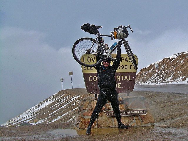
Loveland Pass
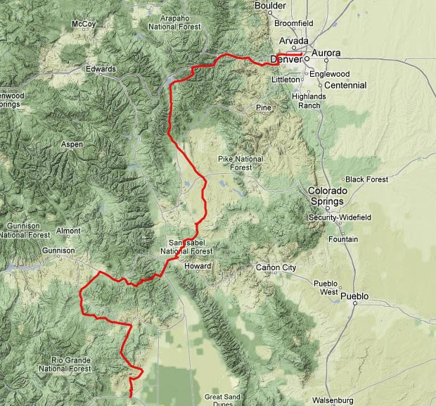
I am perpetually amazed at what adventures lay so close to home, taken on by just strapping on some clothes, tools, food and a sleeping bag to a cobbled together bicycle and just going for it. Last weekend saw me ride from Del Norte, along the Great Divide Mountain Bike Route, with the goal of getting to Breckenridge and from there, taking the I-70 corridor back home to Denver. The goal was to do it before band practice on Sunday.
I got picked up from Denver on Wed. by friendly Canadians on their way to Santa Fe and we all enjoyed a good meal in Buena Vista, camping near St. Elmo and a quick dip in the Mt. Princeton hotsprings the next morning. We took our time to drive out to Del Norte and had a late lunch at The Organic Peddler, which really should be one of those must-stop places on the GDMBR route, but I fail to ever see enough stories about it. Sad to see the Canadians go, I probably started my trip back North at around 4:30 pm.
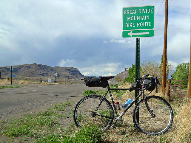
Del Norte has some of the few signs for the GDMBR
My ride on this journey, like most every ride since August, has been on my Surly Crosscheck, slowly being given an ever smaller gear ratio and for this trip, the gnarliest tires (sticky-slow Panaracer Firecross’s) that fit in the frame. What can I say? It’s a good bike that can practically do anything I want to do. My gear ratio of 34:19 is the lowest I’ve ever tried to go and the distance I wanted to cover – 350 miles, much of it off road, seemed somewhat a gamble if it was even possible. But this trip was a bit of trying out a whole lot of things. Can this setup take on the GDMBR? Could I, and still feel good, have fun and feel as if I could go on for another 20+ days?
I have to admit, I was testing the waters to see if I wanted to try doing the Tour Divide Race again this year. It’s not so much of a cost to spend three days out in the sticks to see if it was all still that much fun if my form was good.
Got about 2 miles into the route, until a forest service truck stopped over and had a chat – turned out to be a friend of the route – a guy named, “Steve”, who has a hand in helping keep the forest roads in the area in shape for all the people that use them and to work with the community on the GDMBR itself. He took a few photos, so perhaps I’ll see ’em soon.
The ride out North on RD 665 was practically perfect – no one else out, great weather, sun slowly going down and feeling energized. I thought perhaps of riding all night and skipping sleep, but around 2:00 am, I thought it best to take a few winks, wake up early enough in a few hours and get to the first resupply in Sargents before Marshall Pass right when they open. Around 80 miles on the route – not bad for a half-day, I told myself.
Up again by 7:00 am – a little less than 5 hours of rest and a good pace for racing and a good downhill + paved road to Sargents. The restaurant wasn’t open yet, but good enough microwave burritos and some fresh coffee with coffee cake made by a local did the trick. Marshall Pass was gated off to motor vehicles, so I had it all to myself. A thunderstorm ran into me while I climbed, shooting down snow, then hail, as well as thunder and lightning. Colorado staples, I guess. Back in Del Norte, there was talk of weather moving in, so it wasn’t too much of a surprise to find it.
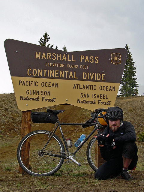
Marshall Pass
Another big downhill into Salida, I noticed the weather was moving in from, it seemed, all directions. Low-flying clouds just sucking in the landscape. It didn’t look good, but I only had lunch on my mind, and booked it to Mama’s for a some food to eat there and a chicken burrito to go. Started raining as I finished lunch, so I thought I’d do some wait-and-seeing at the local coffee shop – as Kent Peterson’s truism states quite correctly, one never loses time stopping for coffee.
The rain though, only got worse as I sipped my cappuccino and flirted with the baristas, two seemingly strange talents I posses naturally. And, well – then it let out, so I moved out and to the supermarket, where I picked up a roll of packing tape, some plastic bags and some kitchen gloves – all to keep the extremities somewhat dry and warm, if it did decide to start raining again.
Although it seemed a gamble, I decided to go ahead and go up and over the Indian Hills and into South Park, where very little trees and even less man-made structures exist. If it was to rain – or even snow, I’d be in trouble. Even backtracking back to Salida, would mean re-summiting the saddle of Cameron Mountain.
Indian Hills, Outside of Salida, CO
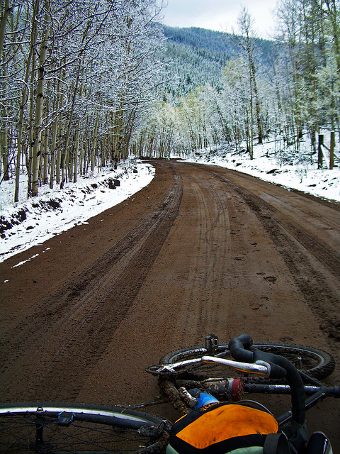
The road up certainly was beautiful, but it also boded badly for the rest of my ride. The rain down in Salida had fallen as snow just a few miles north and not too much more elevation. Summiting the saddle, it looked as if elevation had nothing to do with it: South Park was covered in a thin blanket of snow. The dirt road had also turned to peanut butter-like mud and the weakness of my setup was showing – my canti breaks and almost-no tire clearance were perfect harbingers for the mud to get stuck and cause my wheels to stop turning. To be fair, I think most any setup would be having problems, but wanting forward motion as quickly as one can and not even being able to ride a bike on a fairly level road is disheartening. Luckily, it seemed that the super-saturated dirt on the road was only in a few, low areas, and the majority of the route – although slow – very slow, was still rideable.
And then, it started snowing again.
Around the time it started to get dark, the flakes started flying again. And I wondered, well, how long was this going to last? As the snow on Marshall Pass was there and gone in an hour – would it be better, or worse here?
And then, I got lost.
I’ve gone through South Park twice. There’s not too many roads, but there’s simply no landmarks to use for manual navigation, except the random sign. Well, I passed a sign that looked like a road marker – but instead of say, “53” – the name of the road I wanted to be on, it said, “19” – which wasn’t any road on my map. The last – well, the first junction was 5 miles back and I made the decision to go all the way back and take the other road, somewhat hating myself.
And sure enough, the other road was the wrong road – and quickly dead-ended. So grumbling, I rode back to where I had previously turned around. So what was the, 19? “Bet that’s the mile marker, distance from here, to the highway”, I told myself, as I reset my speedo to see if it counted that many miles.
At this point, the sun was gone, hidden behind the clouds, and practically below the Collegiate Peaks to the West; the snowfall, unrelenting and everything around me becoming ethereal, coated with grey/white. My head torch was useless, as it only hit upon and reflected back the soupy flakes falling down. So, I turned it off and kept it off. Using only the slight differences between the texture of the road and the surrounding brush, I simply kept riding, as even the difference between road and brush were slowly becoming much the same: a undulating mass of 33% grey all around me. After they fused, I just used the shadows from the diffused moonlight that would mark the ditches on both sides of the road, and made sure to be somewhere in between. The snow on top of the mud made everything run in slow-motion, as well as make my travel almost silent. Without much feedback visual or audibly, I was waiting for my mind to lose any sort of waypoint and to slowly spin what I could see end over end, fighting to figure out which way was up.
It was also getting late and I was wondering what exactly I was going to do. The nearest town was Hartsel, but given my wrong-turn, my speedo wasn’t set up with much precision and I had little idea on how much longer I had to ride to hit the highway outside of Hartsel and then the town itself. Stopping to bivvy seemed like a bad idea. No trees, no structures and it’s still snowing. A fairly miserable time to be had. The only thing to do was to keep on riding, as my feet and hands became ever more wet and cold, and my mind becoming fatigued from the stress. Not much in terms of traffic on this road, but a few tire tracks showed that there was some activity and the tracks themselves at least came in handy as areas where the snow had been packed down, which made the riding faster –
or muddier, depending on what fell and when. Now, instead of just being covered in snow, my bike and I were becoming covered in snow and mud, which stuck to everything. My machine again seized against the very elements that made up the road it was trying to ride on top of. Pedal, pedal, pedal – push, push – pedal, pedal, pedal –
Until at last, the highway was discovered. I looked at my speedo – just about 19 miles. Damn sign.
Hartsel was sailed upon quickly. After Hartsel, there’s another 30 miles of South Park, until Como. Another 30 miles of muddy, snowed in roads. Being almost midnight, I decided it best to stop for the night – ’round 145 miles for the day in fairly schizophrenic conditions. Knew just the place to pass out in – a kids-sized playhouse in a little corner of town.
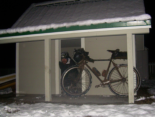
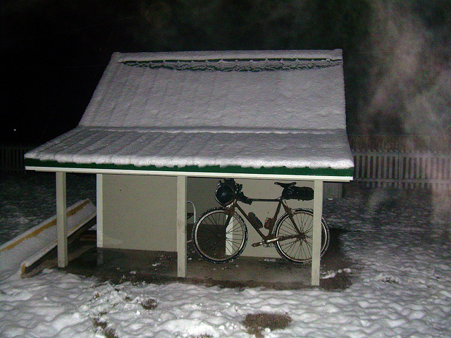
Playtime.
If you squint just so, you could imagine it being a New Zealand hut, but well – it really is just a pint-sized house in a playground. But it literally is one of the only shelters available for miles around. Slept like the dead, until around 7:00am, where I got up and got some viddles at the only restaurant in town. Eating there this time was good – I’ve had mixed luck previously, but damn did all the greasy food hit the spot. I had simply walked out of the Hartsel Hut in my long underwear, ditching my bike and gear for the time being. Everything was either wet, muddy or both and it was going to take some time, and a garden house with running water to fix that, so after breaky, I looked for exactly that.
I found one in back of closed self-proclaimed trading post, so I asked the gas station next door if it would be alright to use it. “I really can’t speak for them about that!”, replied the gas station and next door liquour store employee. “Fair enough”. I wasn’t going anywhere without some cleaning up, so I gathered everything that needed a wash and decided to ninja it. To my surprise, from the time I first found the hose and then gathered up my gear and walked over, it was open and bustling, so I walked in, order coffee and asked myself. They were happy to help and soon my gear and bike were housed down.
With a fresh-ish bike, and the sun up to see what the road conditions were, it became apparent that going through South Park on a dirt road and then taking on Boreas Pass was a Bad Idea. The threat of yet another snow storm later in the day was strong and upwards of four inches had fallen on South Park, more surely higher up on the pass. Luckily, Highway 9 passes not a mile away from Hartsel, and it goes all the way to Breckenridge, with one pass (Hoosier) in the way. So that’s where I went.
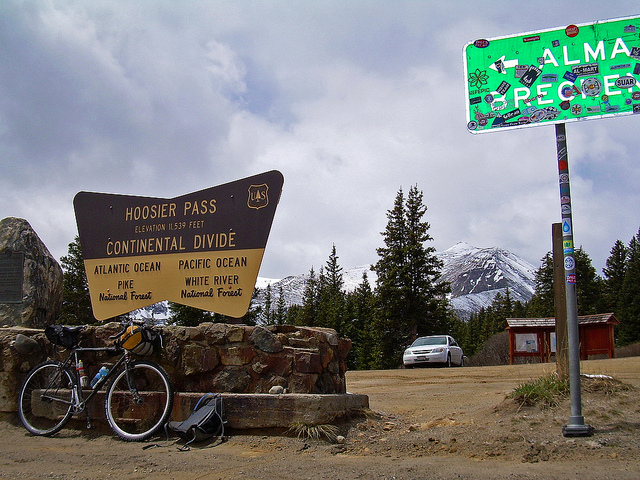
Hoosier Pass
Couldn’t have been a more boring start to a ride. HWY 9 goes invariably straight for 40 or so miles, until the pass, which is nice, but short and then downhill in to Breckenridge. Highlight of the segment was passing another cyclist, touring the route, with a dog and what looked like a miniature horse trailer for the dog and must everything it seemed he must have owned. The differences between the style of our travel with what should be similar modes was bewildering.
Lunch was consumed in Breck, and I made haste out of the mountains, as the weather again was closing in and rain was threatening to fall. I had still a big pass to get over – Loveland Pass, at almost 12,000 feet and getting socked in on the wrong side didn’t sound like much fun. And that’s almost what happened.
As I was climbing the 8 miles of road from the bottom of Keystone to the top of the pass, it started lightly snowing, then hailing and then thunder claps and lightning filled the skies, as I rode straight into the storm. If I were hiking, this would have been a major sign that it was time to get DOWN as soon as could happen. But, my interest was to simply to get home, so I pressed on, intelligent or not. About this time, I ran out of gas, trying to go too fast and going got much slower, not helped by the headwind that had picked up. Lots of stopping.
Made it inevitably to the top and another strange sight – a group of cars were parking on the lots up top, and the occupants were coming out with balloons! We’re in the middle of a thunderstorm, there’s hail, wind and snow and these people are celebrating, wanting some sort of photo op. I felt slightly less stupid, as my plan was to get up and to get down as fast as I could. I didn’t stick around to see what they were doing, but one of the occupants was a completely decked-out in spandex cyclist, who instead of riding to the top, had merely been a passenger in the car. He was spotless and I myself and my bike were both beyond gross at this point. He met my eyes, I pointed at him as I started down and yelled, “CAUGHT-YA!” and began my windchill ride of misery, commencing the 7,000+ feet of elevation loss in the rain and snow, at least happy that my misery wasn’t at least, acted out.
And miserable it was. For whatever reason, I decided against putting on rain pants, and just got soaked through. Stopped in Georgetown at the only place I thought could help: a pizza joint. With its large oven, and laid-back, bike-friendly employees (sticker in the bathroom reads: in Leadville, we still hang bike thieves!“), I knew I could grab some food, some coffee, dry out and no one would bat an eye. Collected some plastic bags from the pizza dude, wrapped those around my feet, wrapped that with packing tape and made my patented waterproof socks in-a-hurry, which worked fairly terribly for the rest of the route.
A good downhill to Idaho Springs just left me more wet and cold, but I decided to blow through town to beat the now, setting sun. Floyd Hill awaited – not a particularly long, or hard hill, but when one is fatigued, it can seem almost like a brick wall. And I was fatigued. My pedaling was slow and my bike creaked. Until it didn’t. Because something stopped creaking and started snapping: my chain. Picking it up from the road, I examined the damage. A few links were busted. As luck would have it, I had enough stuff to fix that the problem and links to replace those that were now destroyed. And was off, until I wasn’t, as the drivetrain creaked again until it didn’t, and I again picked the chain off from the ground and “fixed” it again. All of a sudden, I was beginning to run very low on chain links. “Hold, damn you.”, was all I could say to my poor, abused, used up chain, recycled probably from a chain used on some multi-thousand mile bike tour a few years ago. With slight protest it did hold tight and from the time I took fixing the chain, the rain had finally stopped, and I did the rest of the route simply cold and soggy, instead of cold, soggy and being rained upon.
Coasted back to the house at around 10:30pm, a delightful shower, after peeling everything off. Another 130 miles for the day.

Justin,
Sounds like an awesome adventure. This stuff is cool, thanks for sharing.
I live in Ohio, my dad lives in Loveland, CO. He sent me your blog after I sent him a journal of an adventure I had last weekend. It was a 24 hour Adventure race in WV. It was tough for me, but man, nothing like what you’ve described here. I think I’ll keep reading and check in to see what else you’re up to. Thanks again.
Mike J.
Thanks for commenting Mike! I think you emailed me too, so I’ll reply to that separately –