Like this? Follow me:
I love drawing lines on maps and dreaming of sufferfests to do. I seem to squeeze out the most enjoyment from long ridge runs. I love being up high, teetering on top of a knife edge between two drainages, without the need of a trail to follow, yet having an obvious route in front of me. I revel in the exposure the position gives me to wind, weather, and of course: gravity.
The Continental Divide makes an obvious target for my doodles, and many of my past fastpacks have used segments of it already – either in whole or in part. Last year, I traversed the CD between Milner Pass and Berthoud Pass – located just outside my back door and earlier in that same year I traveled from Loveland Pass to Guanella Pass with a bike lashed to my back. Previously, I took on the Mosquito/Tenmile Range in total, where the CD makes an appearance for a few peaks (McNamee, Clinton, Wheeler), before bowing out. And of course, I’ve even ridden the Tour Divide Race on a mountain bike, which crosses the Continental Divide some three dozen times or so. All these trips had their unique aspects, and each one I believe is an ultra classic. What to do, next?
Nolans 14 is always something simmering on the backburner for me, although the attention it gets actually makes it less alluring for me. It lacks the adventure I crave – I’ve been on all these mountain many times already. I’d rather be somewhere a little more solitary. I’ll (hopefully) do it eventually, if not just realize this white whale of mine (I’ve failed 3x to try to complete the line) is a ghost and get on with things and complete my own fastpacking guide on it. I’ve been looking at the Continental Divide as it weaves through the Sawatch a few miles west of that line. The ridge here extremely appealing to me as an earlier season objective.
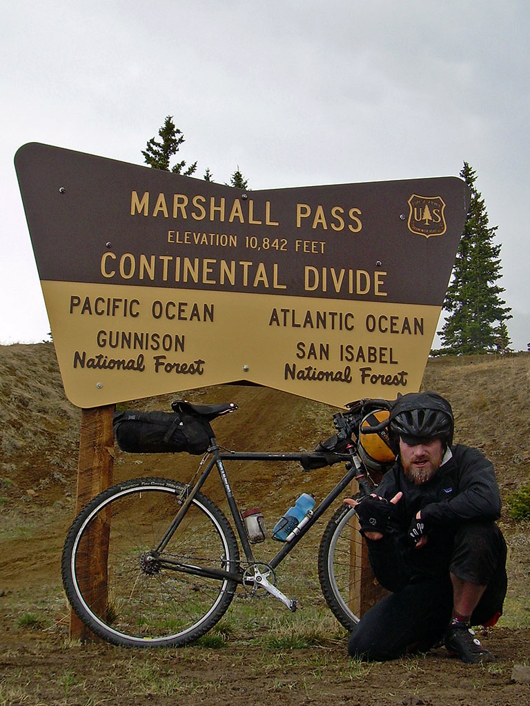
The start would be Marshall Pass, a place I’ve been many times, as it’s a crossroads for the Colorado Trail, the Continental Divide Trail, the Tour Divide, and also something I used for my own Tour of the Highest Hundred.
Further south, the Continental Divide itself goes into the lowlands of the Cochetopa Hills, Sargents Mesa (which is totally haunted) and shortly after into the La Garita Wilderness – so I would be traveling north, as that exits out of the Sawatch, and into the San Juans (eventually).
I would plan to end at Tennessee Pass, which is a few miles north of Leadville. The Continental Divide continues over the Ski Cooper Hill, then into private property of the Climax Molybdenum Mine – makes a good point to stop before all that. From there, I can try to hitch a ride to Leadville and afterwards: pizza.
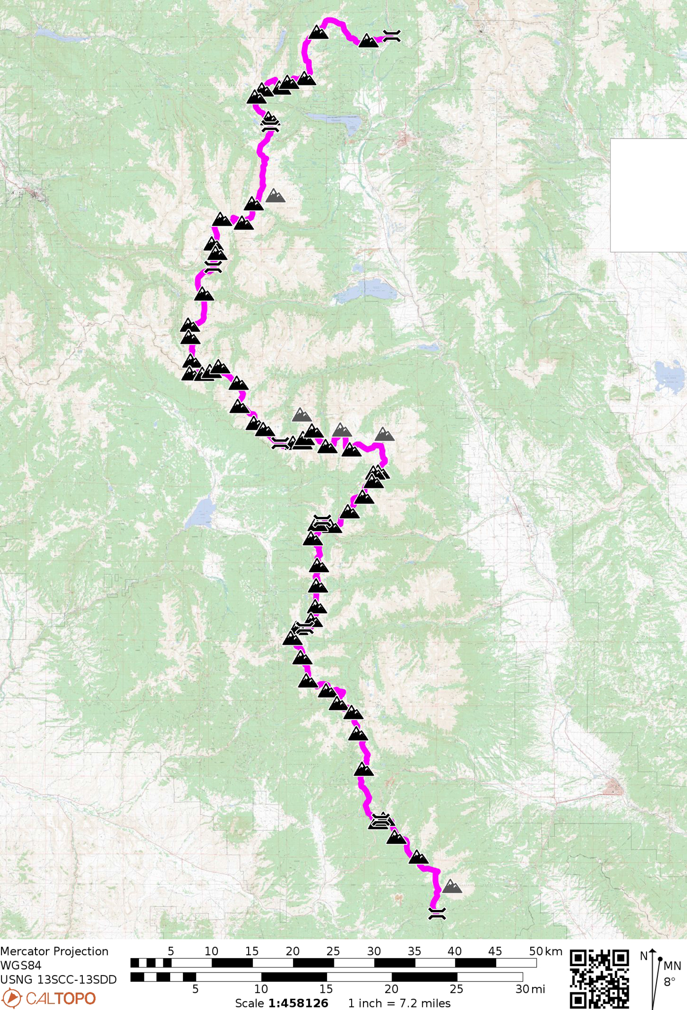
Between those two passes are (and this is all rough numbers so don’t hold me accountable yet) ~118 miles of ridge line and ~58 peaks with 300’+ of prominence. About a peak every two miles – not a bad haul. The highpoint of the entire section is the mouthful point of, “Massive Far Northwest Peak” at 14,158′ (Mount Massive is ~mile away and off the ridge). Lowpoints are essentially Tennessee Pass (the end) and Marshall Pass (the beginning). Roughly, you’ll be higher than those two points for the entirety of the trip.
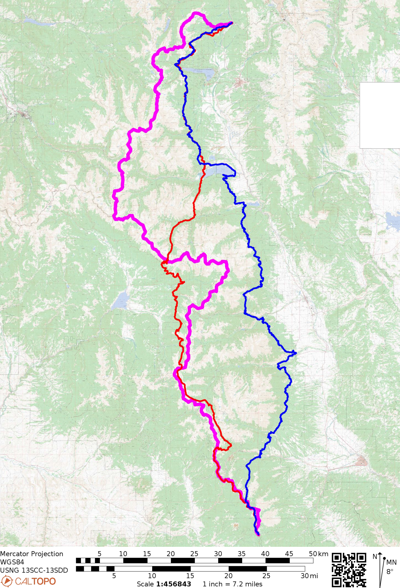
Here’s a map and here’s this all on Caltopo, if you want to explore the line yourself:
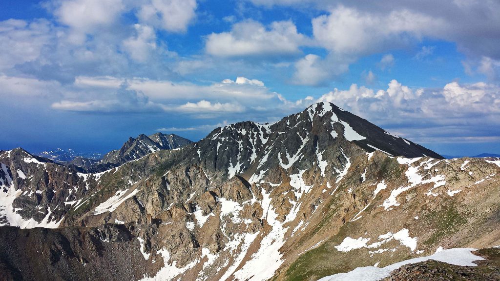
What may separate this line from many other lines – or perhaps any line in Colorado is the lofty elevation you’ll sustain. For well over 70 miles of the route – from Williams Pass (mile ~24.4) to Hagerman Pass (mile ~99.19), you’ll be over 12,000′ continuously. That equates to essentially being over treeline the great majority of your time on the line. This fact alone makes it extremely alluring to me to walk this line.
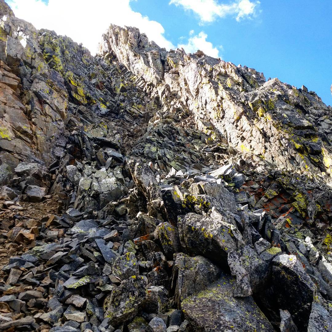
Total elevation gain is ~31,500′ (an, “Everest from sea level” amount) – (actually my initial rough calculations may be off, the elevation gain may be as much twice as much! – see my followup post about this.) The main crux that I’m aware of is the Three Apostles Traverse (loose Class 3).
The Oklahoma to “Massive Far Northwest Peak” ridge is also excellent and exciting.
There may be a few other surprises, but mostly I’d be expecting an “easy” trail-less, Class 2 walk. This wouldn’t be as exciting as say, the Sangres Traverse but I’m also kinda interested in advertising this line as a goal for other people who may not be such masochists. If the line is mellower, these two cruxes could potentially be easy to skip.
How does this route compare to the Continental Divide and Colorado Trail segments it mostly parallels? Why are these trails even there, if one can just walk the ridge? Here’s all three mapped out together:
Good questions. Partially, one takes a trail because well: it’s easier. But you’ll miss out on a lot of the Good Stuff. I know anytime I’ve hiked the Colorado Trail in the Sawatch, I’m a little dismayed that I’m simply walking around mountains, rather than on top of them – not even being able to see above the trees the trail goes through. But is this really the case? Here’s a comparison of the areas between Marshall and Tennessee Pass:
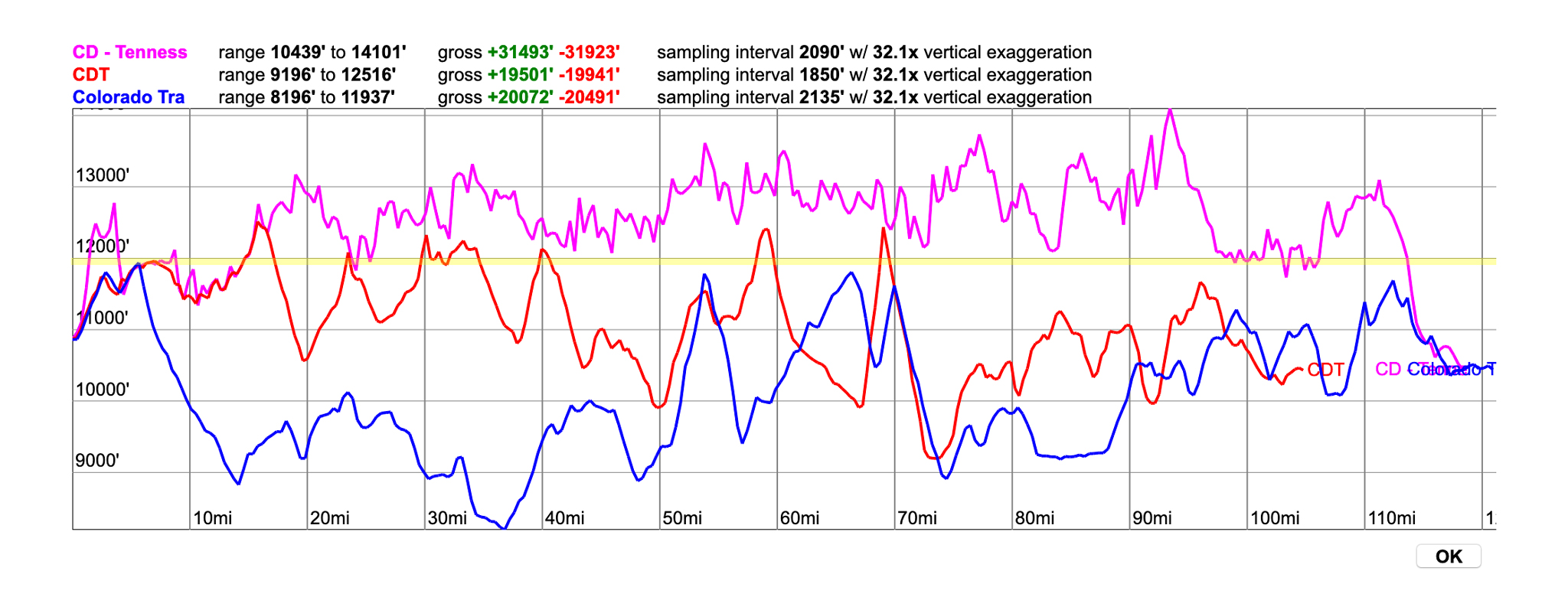
The CT never even gets up that far in this segment of the trail and dips down to almost 8,000′; the CD peaks at around 12,000 +/- a handful of times. And of course: no trail on the magenta line, whereas the CDT and CT is all trail.
The actual ridgeline is in magenta; the CDT is in red, and the CT is in blue. You can see that the relative mileage is similar, but the elevation for the ridgeline is higher (over 10,000′ more), and you’re up there for much, much longer – > 70 miles over 12,000′ continuously at least! This is longer than the Mosquito/Tenmile Traverse in total; The Sangres Traverse has only ~45 miles of continuous ridgeline over 12,000′.
So the actual ridgeline is more out there, higher, steeper, but it’s not completely desolate. The Continental Divide is crossed at a few points by major passes, either by trail, or dirt/paved road. From the start at Marshall Pass, you’ll come across Monarch Pass (paved), Tincup Pass (trail, used by the CDT), Cottonwood Pass (paved), Lake Ann Pass (trail, used by the CDT), Independence Pass (paved), Hagerman Pass (dirt), and finally at the end at Tennessee Pass. For a ridge run, passes are usually good places to bivy, and if you need to bail: convenient places to do that, too. These passes are pretty normally spaced out, too, making for good daily goals.
And then there’s bonus peaks. If one desires, there are a few 14ers, and Centennials along the way – as well as ton of summits that don’t have that special designation, one could summit that are just off the main line (< mile, or so). You’re there already: why not?
Well, because the trip becomes much, much longer as each peak of the ridge becomes an out and back. Maybe limit the list to just the 14ers and Centennials? The ridge to Huron would then be the crux of the whole trip.

That “limited” list would be:
- Mt. Ouray
- Mt. Harvard
- Emerald Peak
- Huron Peak
- Mt. Massive
Three 14ers, two Centennials. Seems doable.
I would personally be most interested in doing this line early in the season – near Memorial Day, depending on snow levels. Some wallowing may need to be done to get up high, but once up high, things should be dry/crusty enough to afford easy passage. And you’ll need some snow to make water from, so you don’t have to exit the ridge.
So there’s a Big Idea for a Grand Adventure. If not me, how about you take it on? Here’s the outline.
