Like this? Follow me:
It’s becoming, “put up or shut up” time my attempt at a Nolans run: Fall will soon becoming a reality as the days are getting shorter and the temperature is surely to drop. I also have a guiding gig in September that will take priority soon. One more lightning fast trip out for a dress rehearsal for my gear selections.
The plan is simple: bus into Buena Vista, ride to N. Cottonwood Creek Trailhead, make a bivy, get up early in the morning and bop till you drop, leaving just enough time to catch the bus back to Denver in the early morning. Pace will be generally as fast as I was hoping to do the actual Nolans run, while bringing all the gear I’ll be bringing – including a bit of extra ballast in the form of food I’d need for the entire time.
One notable missing category of gear I wasn’t bringing – and am not planning to: a sleep system. Even at around four pounds, my current sleep system is still too heavy/bulky to justify towing it along for the scant few minutes a day I actually intend to pass out. The only thing I will be bringing is a large mylar emergency blanket, which I’ll wrap myself in, once I’ve put on all the other clothes I’ve brought (including insulated pants – a game-changer in of themselves).
At the N. Cottonwood Creek TH, I woke up about an hour and a half later than I would have liked – my phone died in the middle of the night and thus my alarm never went off. I quickly packed up my simple bivvy, rolled the bike to the TH info sign to lock it up, and started my day, a bit annoyed at the late start.
My original idea was to scope out the new trail that’s being built up Columbia, as the old standard route’s “trail” is pretty terrible. But, with the sun rising, the trail builders would be working, and I’d be in their way, so I decided to just take the south ridge route straight up Columbia, which I’ve used a few times in the past.
I instinctively left the trail just a little bit after the bridge over North Cottonwood Creek and followed my nose up, trying to stay near the faint south ridge. I happened upon the remains of an old cabin, and what appears to be a very faint road leading to it coming from perhaps the west. Would be something fun to look for at another time.
From the cabin remains, I traveled north into a small patch of Aspens, but escaped them a little to the east. Next time, I’ll just trend east a little earlier, where there seems to be the remains of perhaps an old mine prospect hole.
Once above treeline, the route is actually quite pleasant, and leads you directly to the summit of Columbia, with no real difficulties. Is the South Ridge route worth doing, compared to the (current) standard route? Here’s some comparisons: (from ~Kroenke Lake/Horn Fork Basin trail split)

- Standard, West Slopes: 3.71 miles, +3715′ gain -41′ loss
- South Ridge: 2.86 miles, +3765′ gain -97′ loss
Gain/loss are very similar, but the south ridge is .85 miles shorter. Seems like a big win to take the south ridge.
Once on Columbia, you’ll find a direct ridgeline to Mount Harvard, but the standard guidebook route is to drop pretty far down into a basin above Frenchman Creek. Why?
One, single, 20′ vertical wall that goes at 5.7.
Since I know how to climb (including a very rudimentary knowledge of crack climbing technique), “20 feet” sounds like a boulder problem, “5.7” sounds solo-able, and well: this is a recon trip – it makes perfect sense to give it a go.
I found the majority of the ridgeline off Columbia really fun scrambling. The main towers of the ridge – the Rabbit Ears, where easily bypassed to the west down a sloping ramp that lead to a lowpoint in the ridgeline itself.
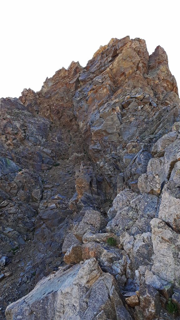
I initially thought that this part of the ridgeline held the crux and having so easily bypassed it, felt a little cheated. But I was wrong: the real crux is a bit more shyer, coming after a fun knife edge/slab section. It features a wall with a hand crack running in the middle of the face, as well as a second crack in a corner.
The crack running up the face initially seemed the more attractive of the two, but getting a hand/foot into the crack proved a bit awkward, as the bottom of the pitch wasn’t flat, but instead was just a continuation of the same one found on the ridge to the south.
Indeed, one felt more like being at the start of a second or third pitch of a route, with pitches of steep slab climbing right below you. If you blow the very first move, you’re going to keep going to the valley floor. Hmm.
I then checked out the crack tucked into the corner, on a wall that was a little less than vertical. The top half for me was perfect fists, in a crack that constricted a bit at the bottom, making things even more secure. If you can get a fist in there to stick, there’s no way it can really come out.
Of course, starting up this crack was also a bit awkward, as there aren’t the greatest feet, but in scenarios like this, you just have to commit and trust your hand jam, and start up. The top of the pitch comes quickly, but is pretty blown out and somewhat of a hole one has to tunnel through without the greatest holds to overcome the vertical wall itself. It has “beached-whale” potential.
I needed to get a good foot jam in with my left foot, but my trail running shoes are a bit thicker than climbing shoes and on top of that, they have a toe-cap that’s useful for running, but not so much for jamming and finding a good jam proved elusive. So there I was, embarrassed and hyperventilating from the effort of climbing a three-move 5.7. The altitude wasn’t helping. I had to rest on my hand jam for a number of seconds between each attempt at getting that damn foot in then crack.
Finally, it clicked and I finished the pitch.
Once done with this small section, it was no harder than Class 3 to the summit of Harvard.
So does taking the ridge save on distance or vertical? Let’s compare:
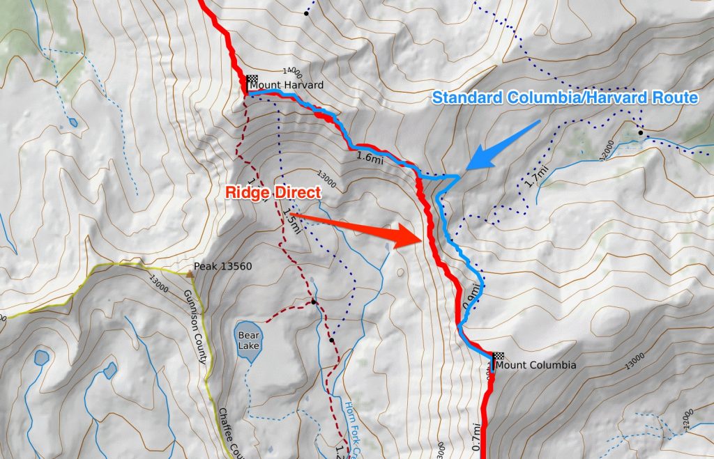
- Standard Columbia/Harvard Route: 2.7 miles, +1836′ gain -1500′ loss
- Ridge Direct: 2.52 mi miles, +1559′ gain, -1216′ loss
Not as drastic as our last comparison. Staying on the ridge is mostly a win in distance, but still only saving .18 miles, 277′ of gain, and 284′ of loss.
I’ve never done the standard traverse from Columbia to Harvard (only the opposite direction), so I can’t compare real-world data, but from Harvard to Columbia, I’ve done this traverse in 2hr 4min in 2014 and 1hr 54min in 2017. The ridge direct traverse took 2:24 – much slower. Now that I know the ridge direct route better, perhaps I could shave some time – but would it be worth it?
Part of me thinks that it may all come day to the time of day you do it. Reading trip reports, there’s so many pity parties of people between Columbia and Harvard mucking about in the talus fields below the ridge. It made sense to me to just you know: avoid that area completely. But, if it’s the middle of the night, with five peaks under one’s belt coming up at hour #24, perhaps a 5.7 pitch of any length in the middle of the night is just not something you want to take on. Columbia to Harvard may just be a psychological crux, no matter the exact line you take.
The descent into Pine Creek drainage is down Harvard’s north ridge. Once near treeline, trend northwest into an obvious gully. Right at treeline, you should be able to pick up a game trail that’ll lead you north east to granite slabs. Descend on top (not on the sides) of these slabs all the way to Pine Creek.
Any other way is full of steep gullies filled with thick dead fall. It’s pretty messy down there.
Pine Creek was running low, and other than having slippery rocks, was a non-issue to cross. Earlier in the season, it’s a bit more spicy. The Pine Creek Trail is found just north of Pine Creek itself.
The route up Oxford starts just east of a small drainage, and follows the faint south ridge of Oxford more or less. Easy stuff. From Oxford, Belford is attained by following a trail between the two, then you descend to Elkhead Pass using yet another trail.
At Elkhead Pass, the decision making gets interesting again. Many ways to summit Missouri, but none of them are perfect. The standard route is to descend Elkhead Pass north and take the standard route up Missouri, which climbs an eastern slope to Missouri’s northern ridge. That’s so long, I’m not even going to entertain it for a Nolans run (although it’s fine for other objectives). Another popular choice is to drop south from Elkhead Pass, and skirt around the east ridge of Missouri, ascending it from its south ridge. This is shorter in distance, but the loss of elevation from Elkhead seems pretty substantial.
A less popular choice is just to take the east ridge of Missouri. It’s short and direct. Why is it not popular? Gerry Roach describes the East Ridge,
“this route is so rotten that it is relegated to this author’s nightmares”
But also only at Class 4, and seems oh-so shorter, so naturally I needed to check it out. I’ve descended the East Ridge before on a different outing, so I kind of knew what I was getting into. The East Ridge has a fairly prominent gash in it, where the poor rock quality gets particularly awful and everything seems to be held by wishes and prayers. But maybe we made a route-finding blunder before? I was willing to give it another try.
The start of the East Ridge from Elkhead seems pretty benign, but the route does get looser, and soon you’re just below the ridge proper on a loose, sandy ledge, look straight up the gash. The obvious gully in front of you isn’t particularly attractive – you can tell that things just want to move, and move down – and take you with it.
But, I wandered instead to the right of the ridge to try to bypass this loose gully and found a sloping ledge that traverses mostly level underneath an overhang. The exposure is fierce here, but the scrambling is easy enough.
This ledge under the overhang gives you access to a steep Class 4 pitch upwards to a hidden v-slot that one can enter into for even steeper climbing upwards. The v-slot has a crack on climber’s right that works well for purchase and ends at the very ridge crest.
The crux of the whole deal may be traversing out of the v-slot from the east to the west side of the ridge. Similar to Rabbit Ridge, once you overcome this one section, the ridgeline is fairly straightforward. The line certainly doesn’t avoid the reputation of the ridge being a chossy nightmare-filled death route, but it’s certainly doable.
We can try to compare mileage/gain/loss:
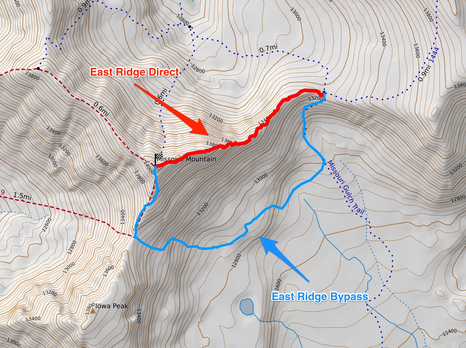
- East Ridge Bypass: 1.61 miles, +1426′ gain -584′ loss
- East Ridge Direct: .82 miles, +925′ gain, -84′ loss
East Ridge Direct seems to be the better choice, if you’re not allergic to chossy scrambling: .79 miles shorter, 501′ less gain, 500′ less loss.
I’ve never taken the bypass before, but on my descent, I did this segment as you would if you were going North to South on the route (so in reverse of what I’m planning), with an eye of being as aggressive as possible with keeping as much elevation as I could. That turned out to be a big mistake, as the footing up high was terrible, and the terrain was cut through and through with small ridges/gulleys. It makes much more sense to drop down all the way to tundra, as is depicted on the map above.
It took me 1hr 4min to get back to Elkhead Pass, from the summit of Missouri (so 584′ of gain, and 1426′ of loss), while taking 58 min to take the East Ridge Direct to the summit (again: more gain going to Elkhead to Missouri either way you go).
Clearly, the winning route choice is the East Ridge Direct, if one wants to go fast.
But again, the question is, would you want to do the east ridge direct say: in the middle of the night – now with nine 14ers already done? It’s another personal question. For me, the climbing on the east ridge is much, much easier than on the Columbia/Harvard traverse and I’d most likely have the confidence and competence to do the ridge direct in that state. I actually found the climbing enjoyable, once at the v-slot pitch.
If I was going north to south, the East Ridge Direct would not as great an option, as downclimbing the v-slot would seem to be much harder and slower. Descending the south side of the notch in the ridgeline, as I did the first time I descended the east ridge may be the better option, but is itself loose, dangerous, and not particularly attractive. Your best bet would be to forgo the ridge direct and wrap around from the south. Hmm: to me, that’s just another reason to go south to north, if one wants to go fast.
After Missouri, my recon was essentially finished, but I was far away from my bike back at N. Cottonwood Creek – at least 16 miles, maybe more. The drainage I ascended to get to Missouri, Pine Creek has a reputation as being the most desolate part of the Nolans route, which I somewhat scoff at (underneath my breath), as nowhere on the Nolans Route are you truly desolate. It’s true that the point on the Pine Creek trail between Harvard and Oxford is the farthest from a road, but in the style I’m hoping to do this in (unsupported) it’s not like anyone is going to meet me anywhere, so everywhere is just as desolate as any other point.
Still, it’s sort of fun to play with the idea of desolation, the same way as a cat plays with a caught mouse in its claws. If one crossing of Pine Creek seems risky due to its distance from civilization, why not do it today twice?!
From Elkhead Pass, there’s really only two options to get back to N. Cottonwood Creek TH. The first is to take the trail down to Pine Creek, until it reaches the Colorado Trail, then take the CT south to CR 365 which itself ends at the N. Cottonwood Creek TH. 20.5 miles.
The other is to re-ascend Harvard, and drop down its standard route to the trailhead. Topping Harvard again seemed the better choice, as the goal of my day was to be both long and hard, and to emulate the type of terrain the Nolans line would throw at me. It would also give me a bonus recon of the line from Pine Creek to Harvard, which I didn’t exactly hit perfectly on my descent.
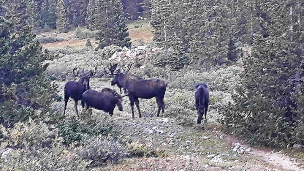
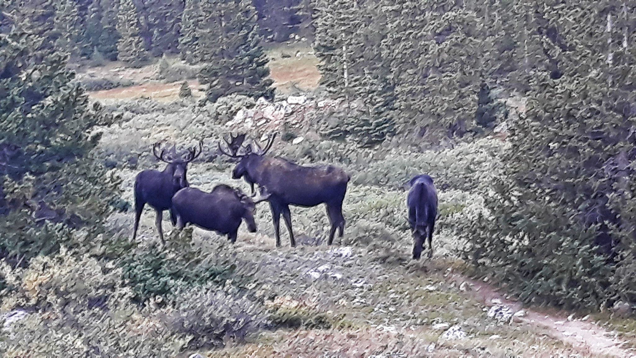
Of course all this tough-guy talk of, “Pine Creek isn’t so bad” was a bit tarnished on my jog down, as I bumped into FOUR moose on the side of the trail, all of whom really didn’t want to move in any direction, except towards me. I had to back away slowly, then dart into the woods, circling back to the trail in a wide perimeter. Yikes!
I topped out Harvard for the second time at 10:30pm, 17.5 hours after I had started.
It’s not perfectly possible, but let’s try to fit this segment into the characteristics of the entire Nolans route in terms of distance, elevation gain, and number of summits. Roughly, Nolans is,
- 100 miles
- 14 14ers
- 44,000′ gain
- 60 hours
From N. Cottonwood TH to the second ascent of Harvard, here are my stats:
- 26.73 miles
- 6 14ers
- 15,079′ gain
- 17.5 hours
Very roughly, you will need to summit one 14er every 4.3 hours to finish the full Nolans line in 60 hours. My pace was at about one 14er every 2.9 hours.
100 miles in 60 hours are 36 minute miles. My pace was 39.28 minute miles.
44,000′ of gain in 100 miles is 440′ gain per mile on average. My elevation gain was 564′ gained per mile on average.
Other than my pace, I’m on target to complete the line under 60 hours. My pace is slower than what’s needed, perhaps because there’s 28% more elevation gain on my segment, then on the entire line – which isn’t nothing. I’m a little afraid using these numbers though, and just creating any bias I want with them. If I use my entire run and formulate the above, I get:
- 34.11 miles
- 15,318 elevation gain
- 19hr 50min
which works out to,
- 1 14er every 3.3 hours
- 34.9 minute/mile pace
- 449′ gain/average
# of 14ers/hour and pace exceed what’s needed to finish Nolans in less than 60 hours and the elevation gain is again higher (albeit barely) than the full line. Hey – Nolans isn’t that hilly of a course, after all!
From Harvard, I descended… somewhat swiftly into the Horn Fork Basin. There was just one more thing to try out: napping. Near the standard route up Columbia, I decided to lay down for a snooze, as I could tell I was getting sleepy. The protocol was really to just put on all the clothes I brought, then wrap myself in my mylar blanket, then use my pack as a pillow. I gave myself a good 25 minutes of snooze time.
I stayed relatively warm, but could have been warmer if I put on my rain pants I’m guessing. The mylar blanket did a good job of radiating my body heat back to me, but a particularly terrible job of insulating me from the cold outside, and nothing for the slight breezes that sneaked through (neither of which is particularly surprising). I was in a fairly cold section of the trail (cold air falls) and I knew this when I picked the area.
Once awake, I felt a slight bit more refreshed, and stumbled along, back to the TH. Back at the bike, I found a relatively flat patch of ground to put down an honest bivy, snoozed for a few hours, then rode my bike back to town in the morning, had a coffee, took a shower, and caught my bus. I was back in Boulder a little more than 48 hours after I left.

Thanks for sharing, Justin. Great read. Those ridge-proper routes have been a bit tempting for me to explore, but seeing your descriptions, I know I’ll be relegated to the talus-hopping. Great to know they go tho!
Justin, these Nolan’s scouting reports are amazing. The detail with the maps, mileage and gain are incredibly valuble for gaining knowledge of the route. Thanks so much for sharing with us!
No problem. Look over my Slow-lans Guide too, which I’ll hopefully be picking up (and finishing) this year: https://justinsimoni.com/routes/backpacking-sawatch-14ers/