Like this? Follow me:
Surprising myself even, I made a trip to the Sawatch to scout out a potential Nolans run. I’ll make it my own, but one of the goals is to do the line, TH to TH (Northbound) unsupported under 60 hours.
Thursday, Prologue
Took the FF1, then Bustang Outrider to Salida. I’m amazed and delighted I can bus to Salida anytime I want for $34.25. This cuts down two days of riding and yes! yes, I’ve ridden my bike to Salida (and back!) many times.
Once in town, I had a fairly expensive, and sadly: forgettable burger, got a few last minute things at the Loaf ‘n Jug, and took an easy ride to the Shavano TH – another trip I’ve done many times before, either to hike Shavano/Tabeguache, or to recon/race the Vapor Trail 125. Made camp at my usual place.
Friday, Shavano, Tabeguache, Antero
Got a-moving a little after 5:00am. Plan was Shavano/Tabeguache, then drop down and rec. a good line to Antero – and even perhaps: down. Weather looked a little iffy, so backup was to do the trio, then descend via Browns/Little Browns Creek trail to the CT, then back to my starting point. Really was hoping the weather held, as any bail to the CT adds some major miles.
The Nolans line usually follows the standard route up to the summit of Shavano – something I’ve never done! Thought it be best to get familiarized with it. Ah!: to be basically fresh to do a 14er hike; it’s been a little too long. Made good time, (I thought). Split: 2:12:24.
Tabeguache is a quick bop from Shavano – these really are somewhat twin peaks, and I’ve done this bit a few times, before. Split: 2:56/43:46
From Tabeguache is really where my reconnoitering began. I usually drop back down to the saddle between Shav/Tab, and side hill it a bit east, before gaining a ridgeline that takes you to the valley below. There’s even an old use trail (cairn’d, even!). I’ve done that route twice, but perhaps there was a faster way?
So, down a very faint ridgeline off almost the summit of Tab – essentially straight down the northern slopes of the mountain. I found talus and scree of middling quality – lots of rocks let loose below me, or tumbling into me. Pretty terrible route all and all.
But, I was still intrigued with the idea of cutting west after getting to the bottom of the talus field, rather that continuing north to the road. You would be side hilling it around the bottom of a prominent ridegline, then into the trees… then into willows, but there’s potentially less elevation loss.
That portion of the route went… and had potential for sure, but the side hilling kind of kills you; and willows suck no matter which way you cut it. I’m not sure there’s a good reason to go this way, as the alternative allows much of the travel you’ll need on a fairly OK 4WD track.
Once at the shallow gully that leads up to Antero, I found a good stride again, and topped out. Split: 6:38/3:42.
Once on Antero, I was considering dropping down to the western switchbacks, and try an alternative to taking the road from essentially the top. A few options looked OK. The first is heading north for just a few paces, then dropping down the western slope on what appears to be OK (in Nolans standards) talus. This will bring you to a talus field that you would need to hike out of, then hike through some forested areas, until you hit the road.
The other option is to backtrack south down the social trail to the high parking lot and, instead of following the road down the switchback south, you can take an old mining track west, go cross country for just a few minutes, then follow a ridgeline just to the north of the set of switchbacks on the west side to hit the road again.
No hill to climb out of, no trees to navigate through. The weather was looking a little on the iffy side, as was predicted, so I decided to instead get outta there, and make it straight to the basin, so not to get stuck up high in foul weather. I had two bailout points, but was hoping to ascend Tabeguache a second time to get that sweet sweet elevation.
The weather was holding well-enough, so I decided to go for the Tab/Shav double. I dropped down how I normally do things, crossing Browns Creek between the two lakes, and up the old avalanche path. But, instead of taking the ridgeline to the east, I took the one to the west, that’ll take you pretty close to the Tab. summit, without having to visit the Tab/Shav saddle.
This route worked out much better. The bottom was of a reasonable inclination, and covered in tundra. When it turned to talus, the talus stayed in place for the most part. Split (to summit of Tab): 9:34/2:55.
Splits coming back were much faster than going the opposite direction so: hmm.
Here’s a comparison of those three routes:
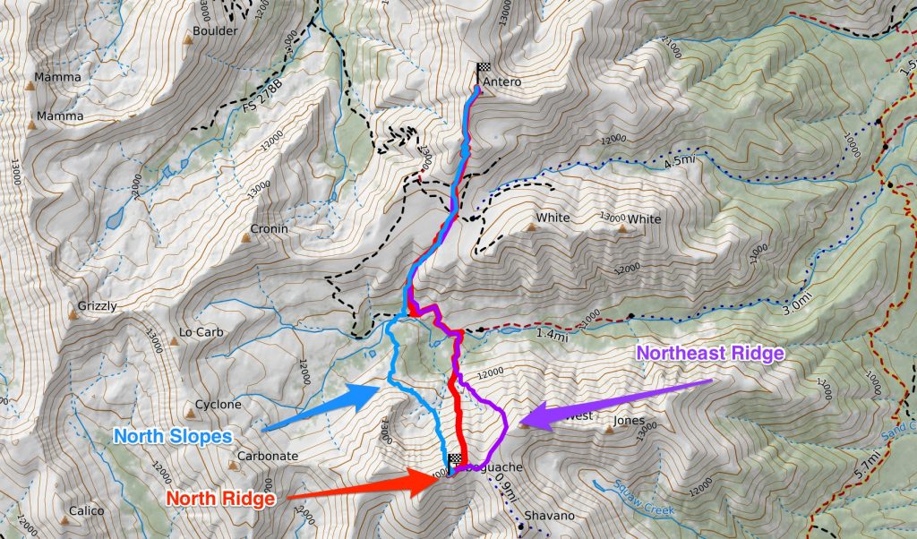
What I’ve labeled the Northeast Ridge is what I’ve used in the past; the north ridge is the new line I just tried (although climbing, rather than descendiong), and North Slopes is the route that goes down the face of Tab., then side hills it west. (from Tab to Antero):
- Northeast Ridge: 4.79 miles, +3000′ gain, -2841′ loss
- North Ridge: 4.73 miles, +3037′ gain, -2890′ loss
- North Slopes: 4.44 miles, +2892′ gain, -2748′ loss
The North Slopes route does seem to be shorter, with less gain/loss. But, the quality of the route: the loose rock, side hilling extra talus, navigating through a forested area, and willows, willows, willows, may negate the slim margin. I don’t think I’ll take it.
Northeast and North Ridge look almost exactly the same. I may take the North Ridge just because I know the quality of the route down below is slightly better.
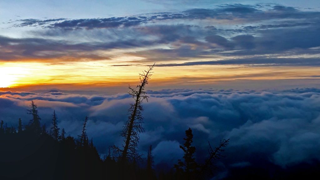
The weather was definitely on it’s way, so I may quick work to get back to Shavano. Once on the summit, it started to rain lightly, but no thunder/lightning. Split: 10:07/32:41
From the summit of Shavano, I was happily able to run/jog it to the trailhead, with minor stops for gear swaps/water. Split: 11:22/1:14.
Once back at the trailhead, it was still lightly raining, and I had nothing left to do for the day, so I just decided to nap, until it was time to go to sleep! Woke up once around 10:00pm thirsty, so sourced water near the trailhead, where my map said there was a spring. The spring was sprunging, so I lucked out.
Saturday, Yale
Woke up around 3:00am, and with dwindling food rations, decided to just make it an easier day. Rode the Colorado Trail from the Shavano TH to Mt. Princeton Hot Springs (and a little beyond). Took Rodeo Road to BV, which is a lovely piece of tarmac – almost a complete coast to breakfast.
After hanging out in BV a bit, I got the itch to get back out, so after resupp’ing at the local City Market (always an adventure in of itself), I spun up to Avalanche TH, which took about an hour at an easy pace.
I was trying to read the weather all day, but it just seemed to stay cloudy, with little if any real precip or electrical activity. But decided to take the chance and do a late recon of Yale.
Yale’s east ride route seems the most appropriate route for Nolans, but it itself seems like it could be optimized, by climbing an alternative – and much steeper southeast ridge spur that then joins the east ridge proper, that will then lead you to the east ridge proper. The off-trail mileage would be about the same, but more of it would be below treeline, which during electrical activity could be a safer place to be. The question though would be if the bushwhacking is bad, negating the cut in mileage.
After poking about a bit, with the clouds above me rumbling, I found a reasonable route right off the trail, with good footing, and not too many downed trees, that led to the ridge I was targeting. And of course, the ridge itself had a game trail on it, that already followed the most optimized route to the ridgeline. Score! This ridgeline started steep and just got steeper, but footing stayed good.
Once it connected to the east ridge proper, I was only .7 miles from the summit. It was getting late, but decided to go for the summit, knowing that I’d be completely benighted coming down. No worries.
I screwed up the descent a bit, but found a good enough line that led back to the trail. From there, I ran back to the trailhead at a good clip. Once back, I was well: tired, so I carved a meager bivvy near the trailhead and called it a night.
Here’s a comparison of the standard route (which some do use for their Nolans run), East Ridge and the “East Ridge Shortcut”:
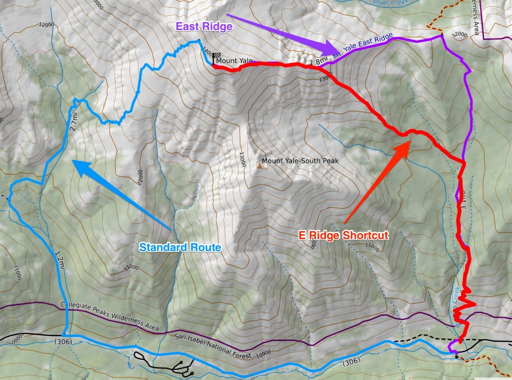
- Standard Route: 7.3 miles, +4938′ gain, -100′ loss
- East Ridge: 4.93 miles, +4961′ gain, -132′ loss
- East Ridge Shortcut: 4.12 miles, +4904′ gain, -102′ loss
The standard route is on an easy trail, but is over two miles longer than the other two options. Yikes! East Ridge Shortcut is indeed a shortcut, being 0.81 miles shorter in distance. The spur ridgeline will be steeper – much steeper than what you’ll find on then East Ridge that’s skipped over, but you’ll be on a ridgeline for a shorter amount of time.
Elevation gain/loss is about the same for all routes.
Sunday, Princeton
Slept in a bit the next day, and had a late start. Weather looked crummy again, but I rode the CT a bit to a good starting point to hike/run the CT towards Mount Princeton. The Nolans route (Northbound) would descend a northeast ridge off of Princeton to the CT.
Supposedly, there’s an “abandoned Jeep road” that starts at the CT, and takes you above treeline, but on previous recon missions, I never found it – or thought I found it for a few meters, then it disappeared. From there, I would climb the very obvious northeast ridge. From the CT, this ridge is 2.5 miles+ long, which is a very long time to be on a ridgeline. Popping out of treeline involves smashing through a particularly dense group of aspens. It’s just generally very time consuming.
On this day, I was in familiar territory, looking for that damn Jeep road, without any luck. This year has been particularly wet, and the ground I was trying to move through was particularly overgrown, and not particularly apt for forward movement. I felt that doing a bit of search for a road would help, so I moved a bit north, and up a very steep slope, hoping to run into the road.
To my surprise, I actually found it, and in disbelief found the road in good shape! Soon as I was making good time above treeline, where the road became a bit fainter, as tundra took over. Nevertheless, I followed an obvious tongue of tundra to a ridge that would, similar to Yale, take me to the main northeast ridge near the summit. The initial ridgeline terrain was somewhat loose and crappy, but afterwards, had good-enough footing. And again, despite protests from grumbling clouds – some of which were rumbling below me, I managed to summit, before hightailing it outta there.
I was hoping to recon the other side, but I’ve done the other side at least twice, so I’ll just have to work with that knowledge.
Here’s a comparison of taking the standard route, the NE Ridge Direct, and going up Maxwell Gulch, then taking a subsidiary ridge, that then reaches the NE Ridge close to the summit:
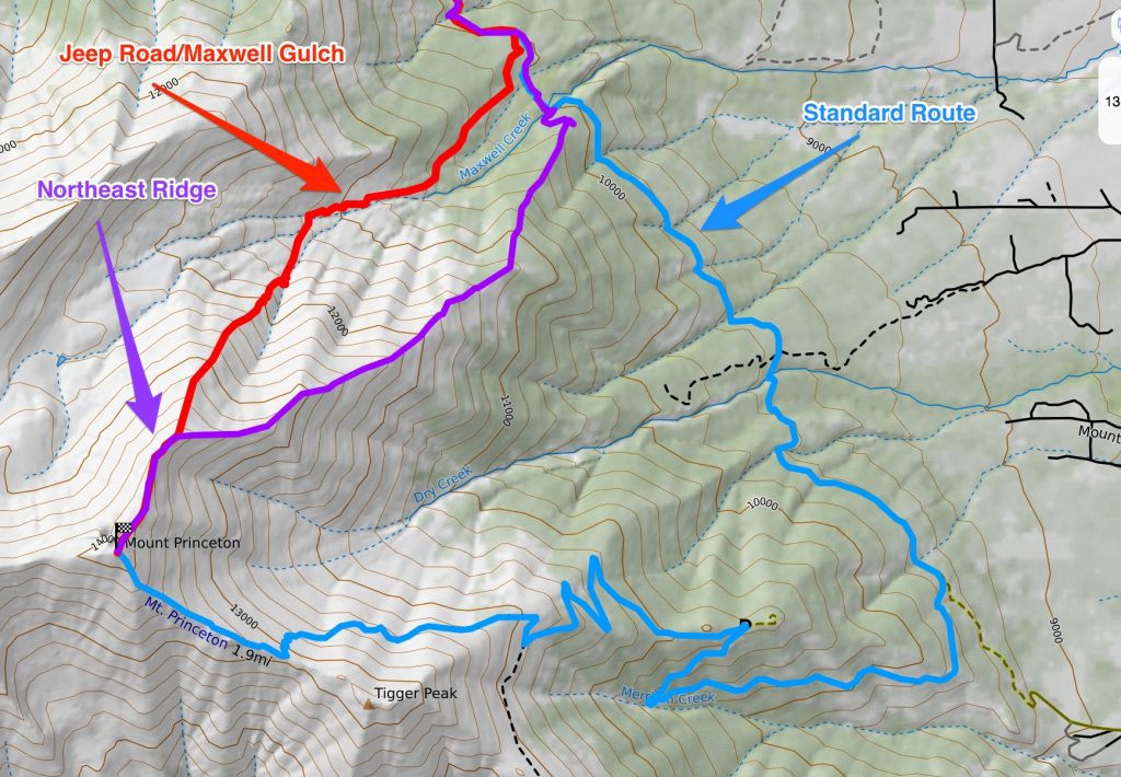
From just this map, it’s obvious just how much mileage you save by either taking Maxwell Gulch or NE Ridge Direct, when compared to the Standard route. Here are rough mileage/elevation gain comparisons:
- Standard: 13.12 miles; +1128′ gain, -6360′ loss
- NE Ridge Direct: 7.57 miles; +576′ gain, -5808′ loss
- Jeep Road/Maxwell Gulch: 7.23 miles, +476′, gain, -5717′ loss
From just these stats, Jeep Road/Maxwell Gulch is shorter (about a .25 mile compared to NE Ridge Direct), with less elevation gain/loss than either of the other two options.
NE Ridge Direct is similar – as the lines aren’t too disparate from each other. But, my hunch is that Jeep Road/Maxwell Gulch will be faster to descend, as you’re off the ridge faster, and descending on easy tundra/trail quickly, in a shorter amount of time.
It may be safer as well, as it’s less time high on a ridgeline. That time you will be on the subsidiary ridgeline is going to be steeper as a result, which seems to be the name of the game for Nolans lines.
I also know from my recon of the NE Ridge Direct that it has a particularly nasty section of young aspens that one needs to bash through, to get about treeline.
With a quick ruin back to my starting point, and reunited with my bike, I organized my gear a bit, and coasted it back to Buena Vista, where beer and pizza awaited. Filled with food/good spirit, I rode out of town to a patch of BLM land to make my bivy, and caught the bus back to Boulder the next morning.