Like this? Follow me:
“I’m getting concerned about the visibility issue.”, my much more careful, much more level-headed hiking partner stated clearly and with enough gusto to make it through the wind and snow.
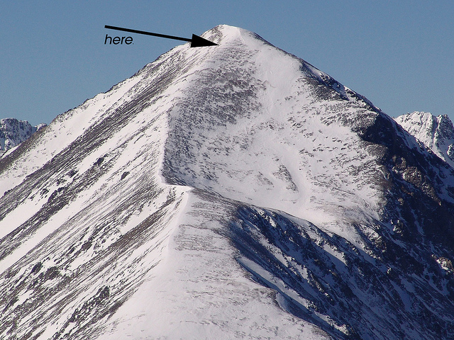
“Yes. I think we’re pretty close. The peak is at that rock.”, I point, “ten more minutes and we’ll re-evaluate the situation. How does that sound?”
“I don’t see a rock.”
And she had a point. The rock was now, gone. Ten minutes became ten steps. We reached a slow-going snowy slope and called it quits.
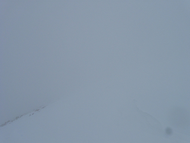
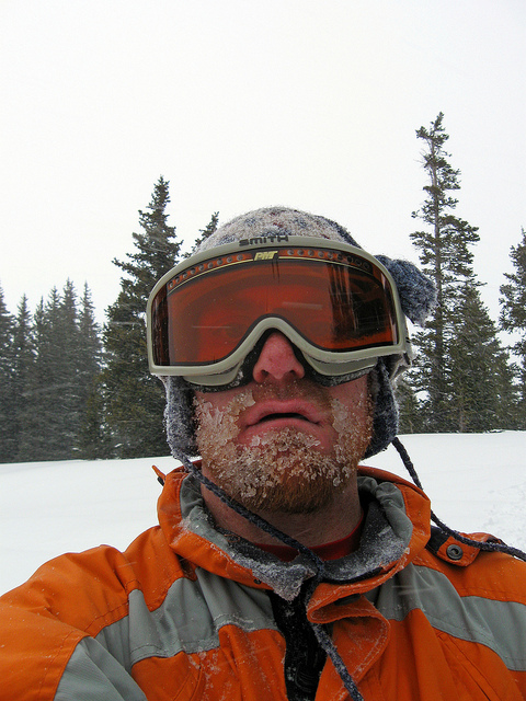
A last look up (unedited photo)
Now, to get back to the trail head, while snow is blowing at a 90 degree angle with little visibility, with no trail or track to follow from 14,000’+. In a cloud. Even at such elevation and conditions, we keep fairly positive. Snapping a shot to show our happy discomfort, we begin the trip down.
The day started out with blue skies and an encouraging weather report: a slight breeze, with clouds moving in, in the late afternoon. Snow, possible – likely even, but only half an inch and not until 5:00pm. We received the weather report right before our 8:30 am start at the trail head.

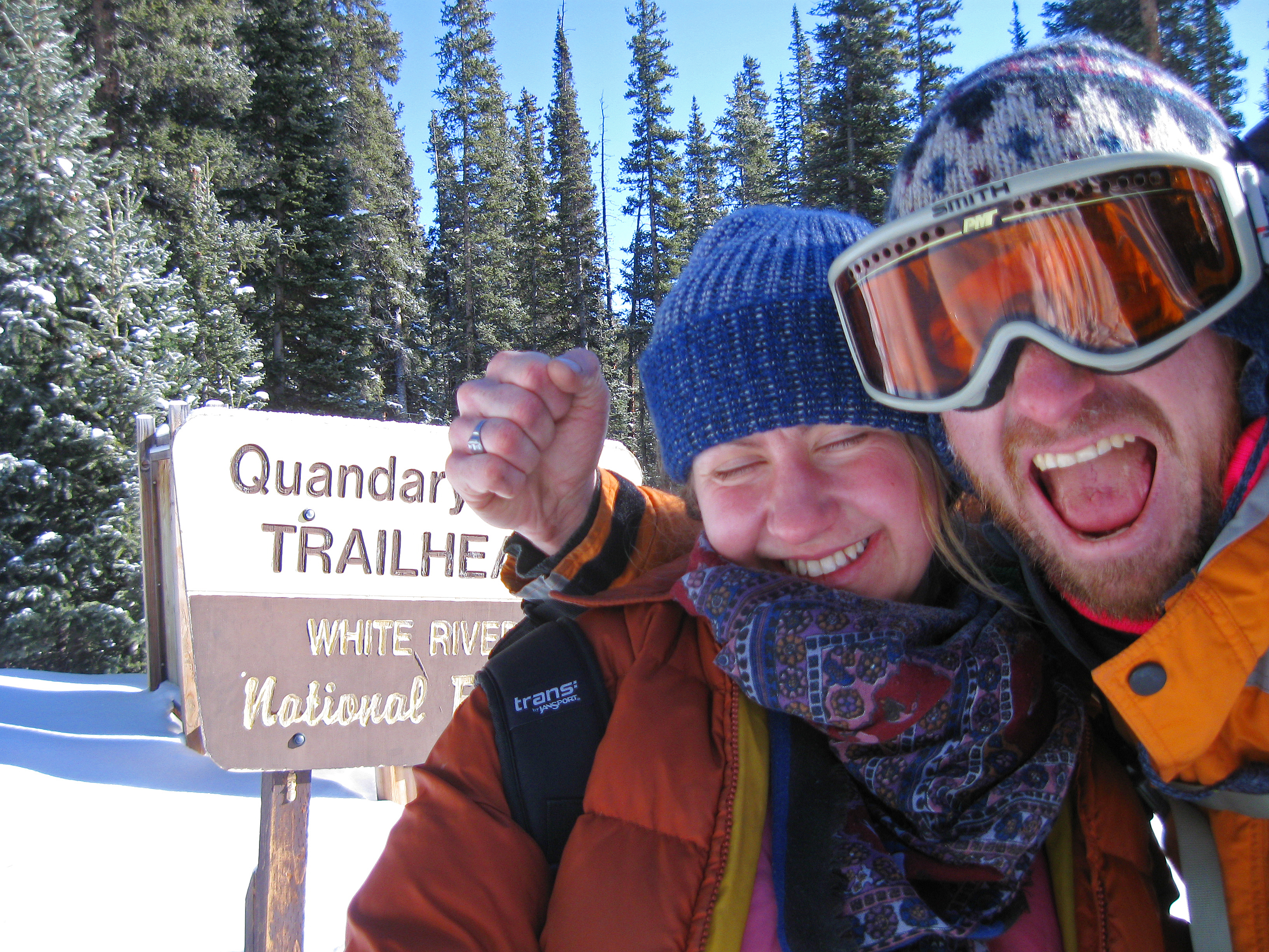
Just excited to be here
8 1/2 hours seemed a pretty doable time to cover a little less than 7 miles, even in the snow, before a little snow flurry.
A dog greeted us at the trail head and followed us for a time. We took it as a good sign. No tags and, ahem, endowed – good at avoiding all attempts at photographing, it was probably a very hearty stray. Hoping it would follow us to the top, I mentally rationed some peanut butter in trade for its company. A black squirrel soon monopolized his attention and we were left alone, again.
Quandary Peak is one of the easiest 14ers in Colorado to summit in the summertime. A Class 1 all the way, with little in terms of surprises in the trail itself. My hiking partner and I have climbed it ourselves in the summer.
Incidentally, before our summer hike, a park ranger met us before hiking the trail at its head to warn us that this was, in fact, one of the most accident-inducing 14ers, due to its proximity to the major ski town of Breckenridge and the vacation-mindset of its attemptees:
The trail head itself is over 10,000 feet and close by Breckenridge is a resort town, attracting people from everywhere, in every shape possible, with every experience level. A well-to-do family from Texas going on a little hike up Quandary getting stuck in a thunderstorm leads to the threat of untimely deaths. Quandary does lack any sort of natural protection, no large rocks, caves etc to hide from even the rain.
Starting out on the hard-pack trail, even in the snow, it was easy to follow. We were being the quintessential “friends, recreationally snow shoeing” photo that you would see in any brochure for any Colorado Mountain town. I thought of this and even apologized to my hiking partner that I make her do such crazy things – that I’m sure, “snowshoeing” for her was like, walking around a lake, or something.
“Are you CRAZY! After all the things we’ve done together, that’s what you think I want to do?!”
She again, has a good point. I have followed her up at least seven 14er summits and quite a few smaller summits in the less than a year we’ve started out together. We both just try to do much with the very menial equipment that’s at our disposal. No one told us we can’t snowshoe up Quandary and snowshoes are all we have!.
Well, I brought along some crampons, rented, as well. We both improvised and maybe that frolicking snowshoe photo op is not so picture-perfect, what with our collected attire of thrift store finds. My own gloves don’t match, my snow pants are on increasingly prolonged loan from my Brother, the goggles found for $3 have a crack in them, the thrifted Columbia ski jacket is as amazing in its role as protection as it is incredible in its unstylishness.
The day went well. Peeling layers off as we went up, treeline was made in good time. The trail was now lost in the snow, but we just followed the ridge line. Clouds had formed on the range to the East of us, but the wind was coming from the South. The area of South Park was easily enough to see from the mountain, bare of any real snow. We felt confident at a summit bid – it would be both our first winter 14er.
Reaching a Point of a Little More Significance in Steepness, we decided to ditch our snowshoes for crampons. Having not worn crampons since New Zealand, it took a little time to get them on, properly. The Equipment Guy asked me if I knew how to work them and I waved him off with a, “yeah, yeah”, very domineeringly male-like. My plastic mountaineering boots were made for crampons, so the task soon was surmounted even if these crampons aren’t made for boots that are made for crampons (if that makes sense), but my climbing partner’s hiking boots took a little more time to get right.
I then gave my partner one of my telescoping climbing sticks and gave her instructions to make it much smaller – the size of an ice-axe, which it was about to stand in for. A little info on how to use it – keep it between you and the mountain – place it, and take some steps, place it again, take some steps – and how to fall, basically with a death-like grip on the ice-axe in an attempt to arrest your fall.
All this I’m basically lifting from the experiences of watching Cliffhanger the night before. I’ve never used one, myself. Mountaineering is something I’d like to pursue, but I have not the time money and a huge bike race in front of me. In the future, something to look forward to .
As an aside and to be blunt, never, ever use a telescoping pole as a stand-in for an ice-axe, except for dire emergencies – the pole is not even close to as stout as an ice axe. But, I wanted to practice some mountaineering techniques, if I ever get to a mountain climb that would require them and I’m a use-whatcha-got kind of guy. Even if that means it destroys my yuppie walking stick.
We ditched our snowshoes at one of the very view cairns and headed up the ridge. Nice going – an easy little hike.
Clouds starting moving in and my spirits somewhat fell. What’s a summit without a view, eh? And then it started to snow. A little bit, almost imperceptibly, and then, well, we were in the cloud of snow. Things became somewhat miserable. The wind carrying the snow right into our faces. There wasn’t much reprieve. Then the white-out conditions. And then, then we were probably over what one would assume is our comfort zone. Time to go down. Maybe 200 feet from the summit – my guess, anyways. Something like:
If I was alone, I would have tried harder to reach the top. It might also have been a bad move. My hiking partner is slower than me and I forget I’m training to reach my physiological peak conditioning in three months and she’s transitioning from being bedridden with the flu.
Getting down proved slow, but easy enough until we reached the Point of a Little More Significance in Steepness again and collected the snowshoes. The definite ridge line soon disappears. I found myself waiting for my partner a lot. I don’t mind being the fastest, but when you don’t move, you start freezing and this was a bummer.
And then, the hallucinations.
“See that?!”, I said to my climbing partner, “I think that’s a ridge, of the peaks West of here. Looks like the weather is lifting!”.
“Are you sure? it looks… it’s another climber! They’re coming towards us! They’re with an animal! It’s sick! They’re with a sick dog!”
“I still think it’s a part of a mountain! NO! It’s BEAR! There’s a BEAR up here!” I start to think of ways of defending ourselves from a bear, at 13,000 feet.
“Whatever it is. It’s MOVING. It’s MOVING TOWARDS US!”
We stared at this damn thing for a good five minutes in the cold, wind and snow, trying to figure out which way this man/bear/animal/thing was moving. Wondering if we should start waving at it.
“I think it’s a pile of rocks. I don’t want to walk to it, that’s where the big drop off is.”
“A pile of rocks, like a cairn? To mark, you know, the trail?”
Finally, we walk towards this thing. It turned out to be several basketball-sized rocks, all in a row. Thirty feet away. That’s the best way I can describe how bad the white-out conditions were and what happens to creative minds in times of stress.
Spoofed by rocks.
We make our way slowly down, taking turns leading. Until my hiking partner states the first time she’s a little concerned: “I’m unsure that we know where we are and where we’re going.”
This is not the situation you want up so high. In any other mountain, we would be in Big Trouble and it’s common in alpinism deaths to find oneself in white-out conditions, become disoriented and well, fall off the face of a cliff. End game.
If my partner plays the Common Sense role, I play the Inexhaustible Optimist. I’m also really loud and I yell much of this out: “You’re not sure?! Haw haw! I’m 100% sure where we are! To the North of us is a big dropoff, to the South… another big drop off. To the West is the Summit, so we just have to go East. East until we hit the treeline and then…” and then I sort of puzzle myself, since I have no idea how to find the trail through the forest. Sounds like No Big Problem, but snowdrifts in the forest could become head-high. Enough to immobilize travel enough that it would take, literally, hours to go a mile. Snowshoes won’t help.
I then realize the only thing I’m using to take my bearings is the slope of the mountain, or lack of slope (and even this is sketchy) and the direction of the wind, which I’ve assumed is coming from a Southerly direction.
My sailing history soon kicks in and I realize that the wind changes direction. Constantly. If it has changed direction, we may be walking right off this mountain.
I am still playing Inexhaustible Optimist, so I don’t tell her any of this. Instead I take off my pack and whip out my compass and bark a, “See?!”. Show the needle pointing North, away from the wind and then point my frigid finger to the general direction we need to go. East. Guffaw again and bound down the mountain.
This actually does work and the treeline comes into site. We reach it at a small rise in elevation – nothing we remember going down with two choices. One to the right, one to the left. I ask my partner for her opinion.
“The right.”
“That’s what I was thinking too. Wait.” I pull out my compass again. East is the left hand choice. East is where we need to go. We think right, compass says left. If we take the wrong turn, we’re post holing a rise of 200 feet. We agree to go left, to continue East. Besides, right was Right Into the Wind and my poor face had had enough of that. I was wearing a beard of ice at this point.
The snow starts to, well, stop falling from the god-damn sky and the trees start to offer some protection from the wind. Visibility is markedly improving. We take a collective sigh of relief. The only thing now to do is to find the trail. If it proves impossible to find, our contingency plan is to just get down, anywhere and hike up or down the main road, to the trail head. It’s not a bad one.
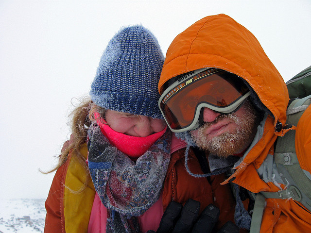
Assessing self at treeline
We move slowly through the drifts to a small ridge and look around. To avoid post holing, I crawl over the deepest snow drifts and have my partner follow me in the now-packed snow. We haven’t yet transitioned to snowshoes. It doesn’t seem worth it, yet. We’ve really, really started to like going down in crampons, instead of shoes, with their long heels that seem to impede downward mobility.
An obvious route reveals itself – enough to attempt to get down. I then spot small aberrations in the snow – near a tree, coming from the left side stopping just a little past the tree itself. Could have been tricks of the wind, or snow falling from the needles of the tree, but they look too regular. I tell my partner that I think I see tracks.
We investigate. The tracks continue some distance South, up a hill. I do recon. to see what I can find. Slow going with so much snow. More crawling technique. Can’t believe that was working! The tracks aren’t from today – we actually hadn’t seen anyone – save a dog on the trail all day. For a mountain that has a conga line in the summertime, it’s strange to have an it entirely to ourselves. It was luck they hadn’t been washed completely away in the drifts. Up the hill, the trail continues and meets up with a more well-defined trail. It could have been the one we took out. I call for my partner to follow me up. Tell her it’s some trail and some trail is better than none. Slipping a little from my Optimistic Attitude, I then tell her it could also be trails of people just like us and we’re about to go in circles, but I end that one with a laugh, to cover it up.
The defined trail soon, sadly, peters out in a clearing of the trees. Decide finally to put on our snowshoes, if what I did was lead us regrettably into a dead-end. But, It still doesn’t make sense that a trail would stop without a beginning, so we feel our way with our poles for packed in snow and follow the invisible-to-the-eye trail, underneath the drifts. Soon, many trails from many people come into view. Trails of skis. Snowshoes and boots. All very faint, but they’re there and we follow the general direction.
We turn onto the main trail and breath a sigh of relief. It becomes another scene in the Recreational Snowshoeing Guide to Colorado catalog. Insane. The weather completely dissolves, save for an overcast sky and we merely skip down the well-marked trail to the trailhead, reaching it at 6:00pm, almost expecting the dog to again, appear to escort us out.
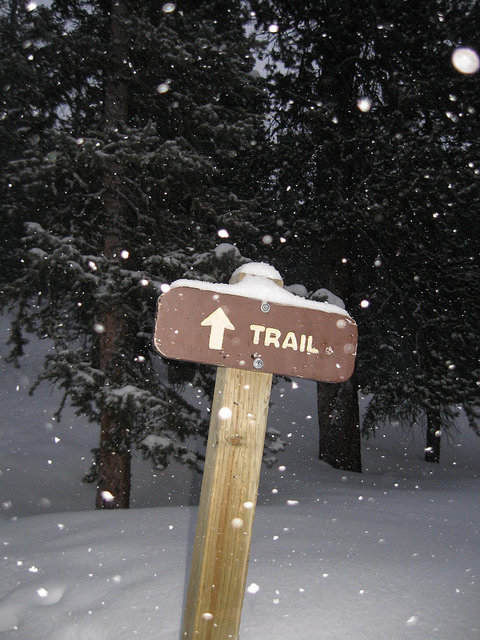
A Good Sign
