The chain of mountains that makes up the Sangres ridgeline from Lake Como Road to Salida is 120 miles, and comprises well over four dozen peaks. Hard place to catch a few Z’s.
My main strategy when it came to everything about this trip was essentially: stay on the ridgeline. Dropping down takes time, energy and adds distance to the already long trip. This strategy is problematic: where to find water as well as a place to bivy, being two. A ridge route differs greatly from a high route where one is simply going over the passes made by the ridge.
I “solved” the water problem, however successfully, by relying on snowfields that still lingered late in the season, helped out by a period of very strong spring snow storm activity. So voluminous was this dumping, I had to delay my trip by about a month. I brought a stove to make water and did what I could when the fuel eventually ran out. It was a risk.

So was bivying on the ridgeline. If a storm rolled in, I would have been in a tough spot, unless I dropped below treeline. Not knowing every square inch of the 120 mile route, I couldn’t even be sure that an adequate bivy could be found. This route is personified by its knife-edge ridges and high elevation: there truly would be places were one couldn’t carve out even the most desperate of bivies. You would need to keep going.
I kept my requirements for a bivy low: I just wanted a place to lay fairly flat on the ground, and make sure my pad didn’t spring a leak. Usual niceties were out the door: water sources close by, shelter from weather, surface to hammer in stakes for a shelter – I decided none of that would be of importance. I’d be in the alpine; these would be alpine bivies. I was up there to complete the route as fast as I could, and when I wasn’t moving, I was simply sleeping: no cooking, no mending, nothing.
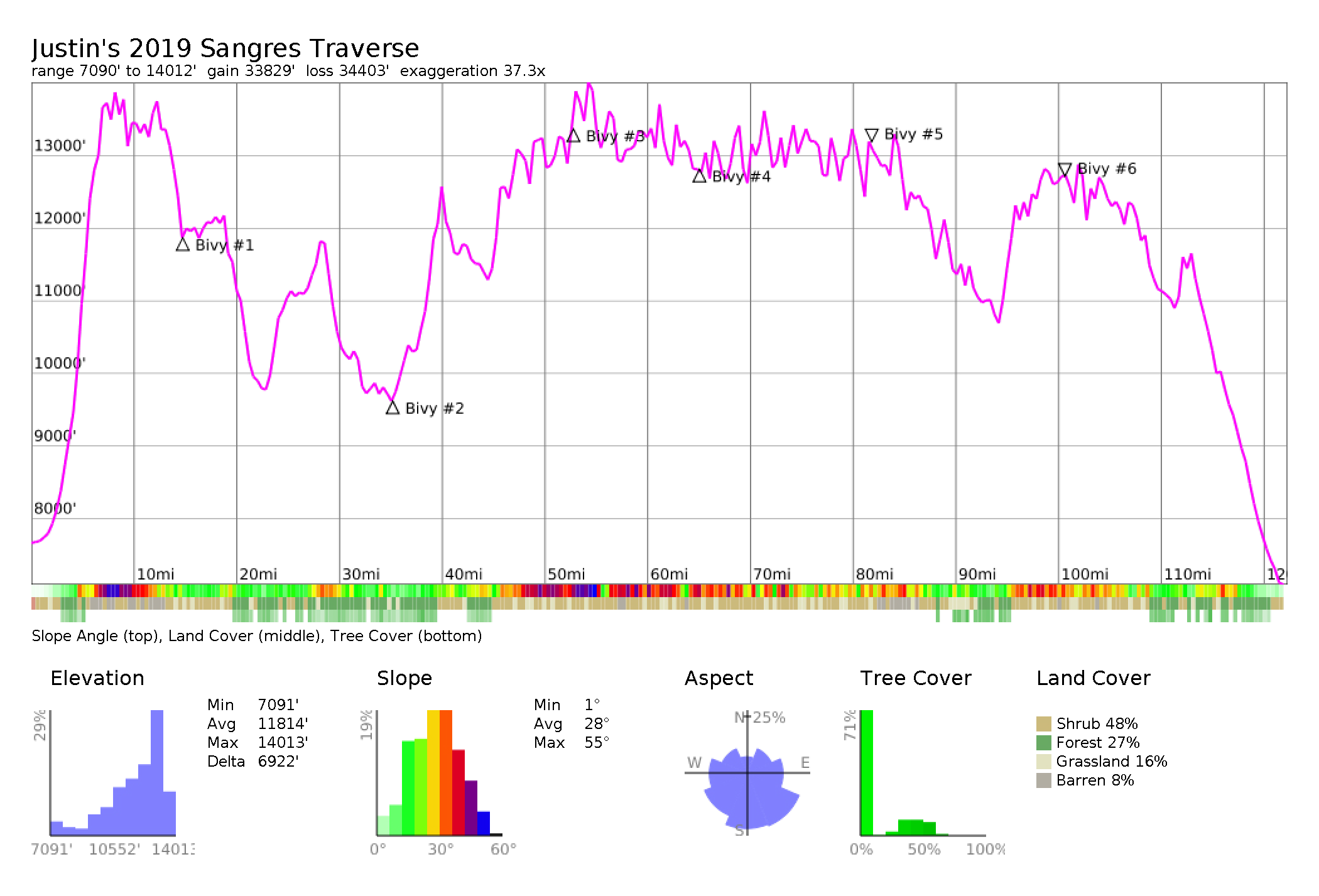
I had anticipated some obvious bivy points – essentially low points in the route (Mosca Pass, Medano Pass, Music Pass, Hayden Pass etc), where I knew there would be tree cover. But there’s over 30 miles of the route that finds itself above 12,000′ and 30 miles is too much for anyone to be able to cover in a day on this terrain. Any way you slice it: you’re going to have to deal with an exposed bivy, at least once – and probably more. So where did I rest, and also: why there?
| Day | Gain | Loss | Miles/Day | Total Miles | Moving | Rest | Bivy |
| 1 | +9729′ | -5531′ | 14.74 | 14.74 | 21hr 31min | 5hr 05min | Raspberry Tr |
| 2 | +5155′ | –7418‘ | 10.46 | 25.2 | 15hr 30min | 6hr 28min | Medano Pass |
| 3 | +10230′ | –5689‘ | 28 | 53.2 | 18hr 20min | 9hr 30min | Crestone Needle |
| 4 | +7706′ | –9139‘ | 12 | 65.2 | 16hr 23min | 7hr 53min | Comanche Tr |
| 5 | +8868′ | –8472‘ | 17 | 82.2 | 16hr 3min | 7hr 04min | Lakes Pk |
| 6 | +8650′ | –9206‘ | 17.8 | 100 | 16hr 55min | 3hr 55min | Twin Pks |
| 7 | +5117′ | -10578′ | 22.28 | 122.28 | 13hr 48min |
Day #1 to Raspberry Trail
The first day of this trip is a very difficult itinerary in of itself. Add in a pack with food and overnight gear for 6 days, and you can imagine how committed you have to be to start out.
I began right at where Lake Como Road meets the highway and took the SW Ridge up Little Bear. You can see from the elevation plot that once you start, you climb up to 14,000’+ without respite – with well over 6,000′ of gain. The SW Ridge route up Little Bear is a Class 4 scramble, and the mile long ridgeline to Blanca, the highest point of the route, is low 5th. The seriousness of the route just begins.
I took the direct line to Ellingwood Point (low 5th), them downclimbed the slabs off its north ridge. Be careful when assessing this part of the route, as many trip reports that climb Ellingwood from the south/Zapata Lake will actually climb up a couloir from the lake, then get onto the north ridge from a subsidiary ridge that connects above the crux of the north ridge; trip reports won’t mention the technical difficults you’ll find. Downclimbing these tricky slabs was somewhat of surprising crux of the day – I would rate it again: low 5th class.
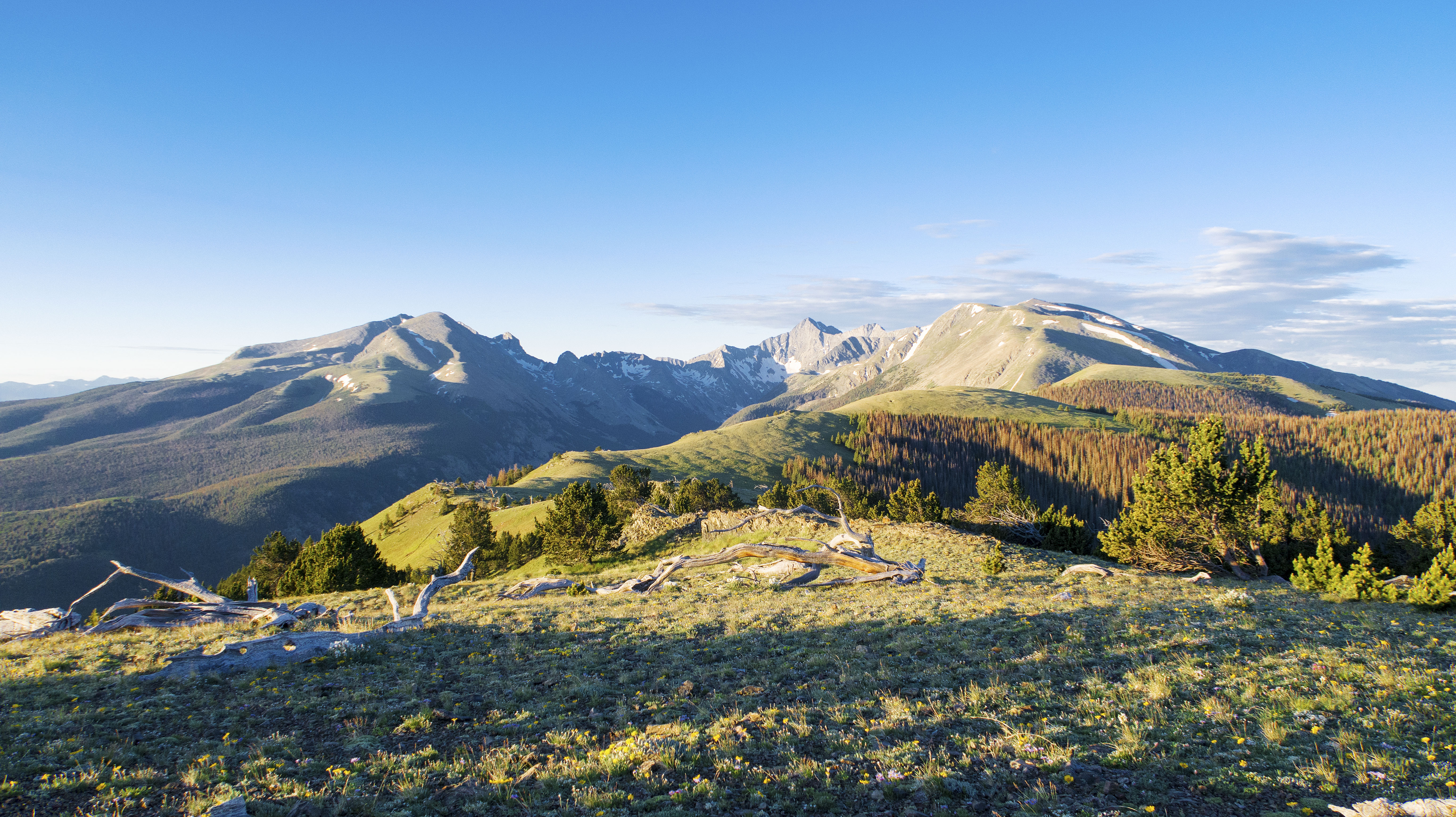
The terrain up to this point does not lend itself well to a bivy, but I managed to find an overhanging wall high up to wait out some electrical activity before the ridge’s crux. But it isn’t until after California Peak that the ridgeline finally starts to drop, and pointy ridges and talus are replaced with rocky tundra.
From Little Bear’s peak, I dropped 2,000′ of elevation before calling it a day where the Raspberry Trail crossed the route. I had only traveled 14.74 miles, but it had taken me 21 hours, 31 minutes to do so. The mile-long ridgeline between Little Bear and Blanca Peak took three hours alone. Perhaps that can give one an idea on what the terrain was like out there. This day was my longest day of the trip in time spent moving.
I stopped because I saw a hill ahead, and just couldn’t muster wanting to continue. My hope was to get to Mosca Pass, but I just didn’t have it in me to go an extra 8 miles.
I woke up during the night and swore I saw a herd of elk bedding down on the hillside. Perhaps I did, but when I got up in the morning, all I saw were bleached gray tree trunks in their place. The first day seemed soon to already be hallucinating.
Day #2 to Medano Pass
Day #2 seems to have a much gentler profile, and much of it was below treeline. I was looking for some respite from the exposure of the ridgeline, and maybe even flowing water, if I wasn’t being too greedy. What I found was difficult bushwhacking, heat and humidity, incredible blowdown, and clouds of mosquitoes. Mt. Zwischen was the only mountain I was able to summit on this day – and that felt like a herculean effort. I seriously screwed up water at this point in the route – not much surface water still locked up in snow! And no creeks flowing. At 10.46 miles, this was the shortest day of my trip in length covered. It basically ties for least amount of gain as well.
I bivvied at Medano Pass, a little ways down the road, at an actual campsite, next to an honest to God running creek. I was feeling very ill, most likely suffering from heat exposure and dehydration, and needed a rest before even thinking of continuing. If I wasn’t in such a state, soldiering on would have been a good idea, as adequate places to rest could have been found further up the route, before one climbs out of Medano Pass in earnest.
Day #3 to Crestone Needle
Mostly rejuvenated , I continued on into the Crestones. This was a very beautiful day, with a lot of intense peaks to summit. I had a full-on asthma attack brewing. I finally crossed the first people I had seen all trip on Marble Mountain, right after Music Pass. Music Pass would have made a great bivy, but again, I just couldn’t have made it that far on the previous day in my condition. It would have made a much better starting off point for the day. After a glorious day of scrambling Marble, Milwaukee, and Broken Hand Peak, I actually bivied on top of Crestone Needle, having summited right at sundown.
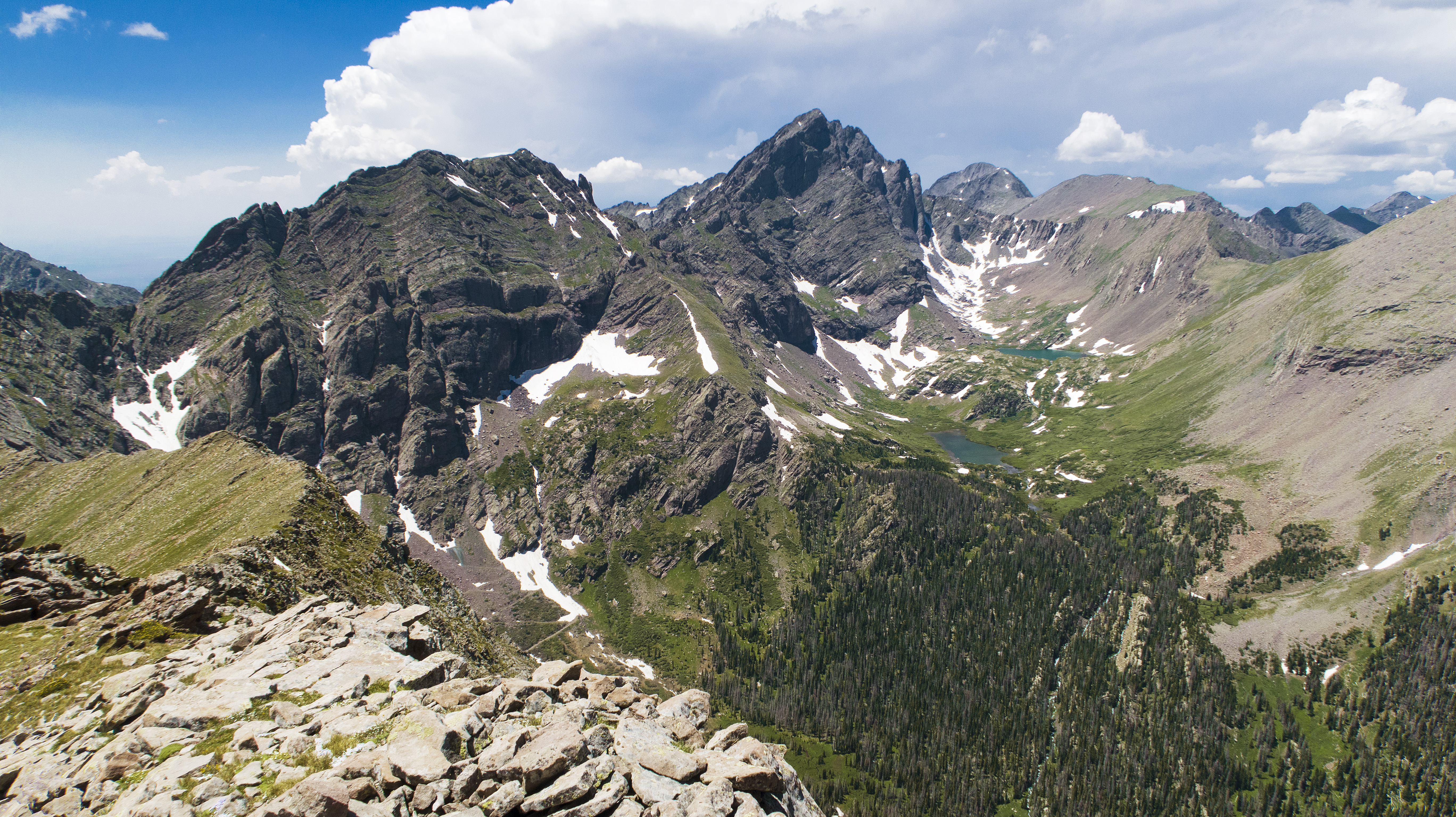
It was an absolutely magical place. Although I could have continued, I also couldn’t pass off the chance to bivy such a awe-inspiration location. Crestone Needle has just enough room for one person of my size to lay down flat, and I did my best to keep myself somewhat protected from the wind. This was, and still is the highest bivy I’ve ever done, and is the third-highest point of the entire line. I seriously lucked out with the weather throughout this trip. If a rogue storm had blown in during the night, I would have been very much in trouble.
Day #3 had the most elevation gained at 10,230′, as well as the longest in length at 28 miles. If you were wondering how far Crestone Needle is from Medano Pass, well: that’s how long. I guess I bounced back from such a disastrous second day.

Day #4 to Comanche Trail
But I also took the longest break that night – 9 hours 30 minutes! The problem with bivying at the summit is that it’s cold and it’s useful to see where you going when downclimbing the headwall towards Crestone Peak. It was not at all casual for me up there trying to downclimb, before my cup of coffee.
Day #4 was another very difficult day of constant scrambling: Crestone Peak had hard snow and ice in it’s NW Couloir that I had to negotiate (thankfully I brought an axe), and I had definitely forgotten the details of the route to the Bears Playground.
The ridgeline between Obstruction Peak (which I summited as a bonus), and Mt. Adams is terrifically rotten to start out, then amazingly complex and technical. I’m repeating myself, but many low 5th class sections were found on these points, but I still tried my best to summit all the named/prominent ones. Rock quality was getting worse the farther from Crestone Needle you got, and that trend would continue to the very end of the range. We’re talking handhold coming off while you’re still using them.
From Bears Playground, you MUST get through Obstruction, Adams, and finally: Fluted Peak to find a reasonable place to stop. Fluted marks the end of the major technical parts of the ridge. Unfortunately for my morale, it only marks the midpoint of the route! With basically four days burned through. My day #4 ended at where Comanche Trail crosses the ridgeline, right after and below Comanche Peak. There’s still 23 miles of the ridgeline that stays over 12,000′, so you’re definitely not out of it.
I only made it 12 miles on this day. For an all-day effort, these low mileages should be frightening to you.
Day #5 to ~Lakes Peak
This day was one of incredible normalization – almost monotony, of the routine: climb 1,000′ to a peak in 1/2 mile, descend 1,000′ to a saddle in a 1/2 mile, then repeat. This felt almost never-ending.
In the 17 miles I was able to cover, I also summited 12 peaks. I ended near Lakes Peak, at a somewhat flat part of the ridgeline, having been spooked enough by how tight the ridgeline still was to continue. It just defies words.
Day #6 to ~ Twin Peaks
I was still 40 miles away from Salida, and things were starting to look a little grim, when it came to fuel (none left), and food (rationing). At the very least, I’d be out a full day longer than I was expecting. Yikes.
This day started out much like Day #5 – up/down/up/down. But finally, I dropped from my last bivy of ~13,000′ towards the last major pass of the trip, Hayden Pass, a little below 11,000′ and back into the trees. Still no water to be had, but I hadn’t passed a tree since day #3, near Music Pass! Hayden would be the lowest I’d get until I finally dropped down for good. Hayden would have made an excellent bivy, except that no water is available.
Once after Hayden, the ridgeline is lower, but it’s certainly not any easier, which is exactly what I feared. Day #6 had my most desperate bivy. I hiked until I couldn’t, then just threw down my bag for a few hours between mountains. I stopped here for my briefest rest of 3 hours and 55 minutes.
Day #7 to Salida!
The incredible fact about this ridgeline route is that there are just no easy days. I was trying to imagine what was the hardest day, and I just can’t pick just one day. Although there’s no technical climbing, the 100 miles over six days previous doesn’t help with moving swiftly. This part of the route has the most blowdown, if you can believe that. I could try to describe it, but it would be beyond belief.
But the end was near. This day saw the most elevation loss at -10,578′ – when you’re up on the ridge, you’re up there for almost the entire trip. This day also had the shortest moving time @ 13 hours, 48 minutes. I just ran out of ridge to range! I spent the night in a motel, falling asleep with all my clothes on, on top of the sheets, forgetting to set any sort of alarm. Fortunately, I was able to get up in time to catch my bus, and eat pancakes right beforehand!
Parting Advice
If you’re going to attempt this ridgeline unsupported, realize that hitting good bivy spots is going to be nearly impossible, even though some do actually exist. Mark these good bivies on your map, but don’t expect to easily land on them. Estimating time of arrival is difficult given the technical and sometimes puzzling routefinding of the ridgeline. Similar advice can be given to those wanting to leave caches: you may not reach them at the time of day you think you’re going to.
Stopping short for the day on purpose is a luxury you will rarely have, if you are hoping to complete the line before your food runs out. If you have the option, always press on, and deal with a less than ideal bivy. 4 out of my 6 bivies were at around 13,000′, with one being above 14,000′! The chances that you’ll hit sour weather are also great. I did not, but that was incredible luck you may not be able to repeat.
I list my sleep system in my gear list. Worked great – wouldn’t have changed a thing, including the sit pad, which I employed often. I brought along four stakes and a simple tarp just in case, which I used once for no reason at Medano Pass. Above treeline, I wouldn’t have had any luck in setting this up.