Work in Progress
Bikepacking to the Colorado 14ers is currently being written and published publicly. Get news and updates by joining the Facebook group, Instagram, Twitter, subreddit, and mailing list.

Introduction
The first leg of our Front Range tour starts at the very toe of the Rocky Mountains in Golden Colorado, right at the doorstep of the American Mountaineering Center. Soon you’ll be whisked into a land of world class hill climbs, gravel roads, flowy singletrack, mountain views, summits, and summit donuts.
The finish of this segment will be the Horsethief Park TH, one of the lesser-used trailheads for Pikes Peak. From there, you can launch your summit attempt on Pikes, avoiding the crowds inevitably found at other trailheads.
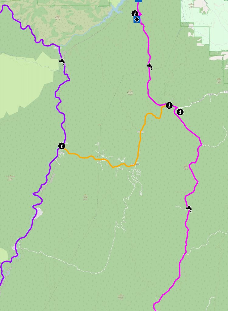
The MTB version of this route will start on designated bike paths and a little bit of singletrack that border the Front Range Urban Corridor, before catapulting you into the Rocky Mountains via Segment 1 of the Colorado Trail. We’ll make good time to Woodland Park gravel grinding up Rampart Range Road, then circle around Pikes Peak itself via the Ring the Peak trail system, until finally finishing up at Horsethief.
The Road version of this route will have you begin climbing immediately up HW 6, have you visit the foothills town of Evergreen, then have you follow the Platte River and Highway 67 to Woodland Park. We’ll jog around the Pikes Peak massif before settling down at Horsethief for the night.
The MTB version of this segment can be done fairly comfortably in 2-4 days; the gravel version in 1-3. Pencil in a full day to hike Pikes. Resupply will be infrequent on both routes, as is water and five star camping options. But for traveling between two large metropolitan areas, you’ll get as much solitude as may be possible on a bike.
Golden Services
Golden will have most any service you need available. If you luck out with finding what you need, Denver is a quick and cheap lightrail trip away:
- Groceries: Safeway
1701 Jackson St - Bike Shop: Golden Bike Shop
goldenbikeshop.com
722 Washington Ave #2 - Gear: Bent Gate
bentgate.com
1313 Washington Ave - Coffee: High Grounds Cafe
highergroundsgolden.com
803 14th Street
MTB Narrative
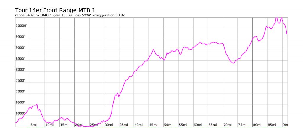
- Mileage: 92 miles
- Elevation Gain/Loss: 10,100’/6,000′
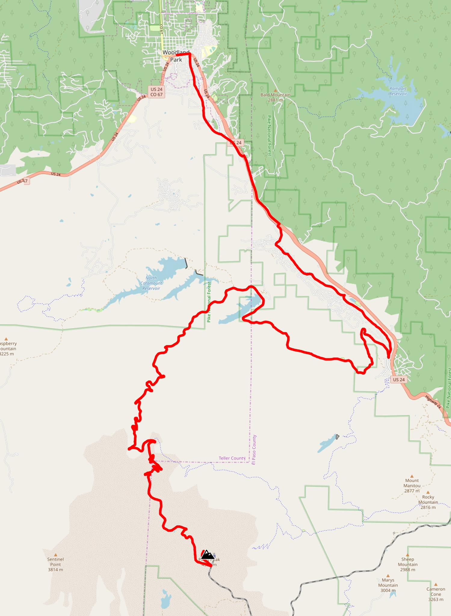
Our route starts at the American Mountaineering Center on 10th and Washington Ave. Head southeast for one block, and get onto the bike path that follows Clear Creek west. Transition onto the designated bike path that parallels 6th Ave, and take this bike path southeast until Heritage Road. Take a right on Heritage Road south. Heritage will fizzle out, but continue onto HW40/West Colfax south, and take this road all the way to the Matthews Winter Trailhead.
The Matthews Winter trail system (Intermediate) is just north of the world famous Red Rocks natural amphitheater. The riding here is fairly mild and extremely picturesque, with massive sandstone formations to rubberneck. Take the trail system south, and exit the park on Red Rocks Park Road, heading south. Turn left on Bear Creak Road and enter the town of Morrison.
Note: Skipping Matthews Winter
Skip the Matthews Winter trail system by continuing south on Hogback Road to Morrison.
Travel east on Bear Creak Road until finding a designated bike path near Soda Lakes Road. Turn right, and enter into Bear Creek Lake State Park. You’ll start traveling onto the E-470 Bikeway south, and will continue on this system until right before Chatfield State Park. It’s not the most inspiring riding, but it’ll get the job done.
Exit right off of the E-470 Bikeway at South Kipling and travel south for a block, then left onto Ute Ave. Jog a bit through a neighborhood, and get onto W Deer Creek Canyon Road. Turn right onto S. Wadsworth Blvd and continue South until Waterton Canyon.
Note: Last Chance for Resupply
Your last chance for resupply is just a little further up the road. The next resupply will be in Woodland Park.
- Groceries: Safeway
8355 N Rampart Range Rd, Littleton, CO
Your prologue is over, and we’re now going to begin what you’re really here for. Ride Waterton Canyon to its terminus, which is also the beginning of the Colorado Trail. The CT in this segment is well-maintained and smooth (Intermediate). You’ll be climbing up into the mountains in earnest, but the trail’s grade should be fairly rideable on a loaded down bike.
At Lenny’s Rest, turn left off of the Colorado Trail onto Indian Creek Loop (Intermediate/Difficult).
Route Detour: Skip Pikes Peak
If for some reason you decide at this point to skip Pikes Peak, continue on the Colorado Trail all the way to Kenosha Pass (with perhaps a resupply in Bailey – it’s a long haul!) and continue with the Segment #2 route narrative at Kenosha Pass.
Head South on Indian Creek to its terminus. Indian Creek is slightly rougher than the CT, but after a brief but stout climb, it’s mostly downhill. The trail crosses Bear Creek a few times (and yes: I have spotted a bear while riding this trail!), and this creek will make for a marginal water source. Surface water is not guaranteed on Rampart Range Road, so top off regardless before the next section.
Indian Creek will terminate at the Indian Creek CG. The trailhead may have running water at various water spigots. Turn left onto W. Pine Creek Road, then right onto Rampart Range Road.
Transition: MTB – Road Route
Instead of turning left onto Pine Creek Road/HW 67, turn right, then turn onto W Pine Creek Road (gravel). Enjoy the incredible descent. W. Pine Creek Road will terminate onto North Platte River Road (gravel). Head south and continue on the Road Route.
Rampart Range Road is a well maintained gravel road that will take you all the way to Woodland Park. It’s very popular with 4WD enthusiasts and there is an entire moto trail system around it, but the trail system isn’t all that great for cycling, so it’s suggested to stick with the road.

A bandana may help over your mouth to keep the dust levels to a reasonable level. If you brought rock shoes, casual roadside bouldering is available at the crags dotting the road. Make a quick side trip to the Devils Head Fire Tower.
Dispersed camping is permitted practically anywhere besides the road, and Rampart makes a good stopping point if you decide to break up this section into separate days. Water is an issue though, as surface water is hard to come by; you’ll be at the top of a long ridge system. The only reliable water source that may be available to you is at Flat Rocks Campground. It’s designated for campsite visitors only, but I’m sure you can work something out with the camp host.
Rampart Range Road will lead you to the small town of Woodland Park and the MTB and Road routes will converge. Most all services will be available to you in Woodland Park.
Woodland Park Services
- Groceries: City Market
777 Gold Hill Pl S - Bike Shop: Team Telecycle
615 S Baldwin St
teamtelecycle.com - Coffee: Cafe Leo
320 W Midland Ave
cafe-leo.business.site
You’ll now be in the shadow of Pikes Peak, and it’s time to make a decision on what route to take to the summit. Our narratives are going to take you to Horsethief Park TH, but several other options exist.
Bailout
Bail east to Colorado Springs from Woodland Park. Take the frontage roads that parallel HW 24, until that’s not an option. The Colorado Springs Bus Station is the stop for the Bustang South Line, which provides service to Denver, and all points from there.
Road Narrative
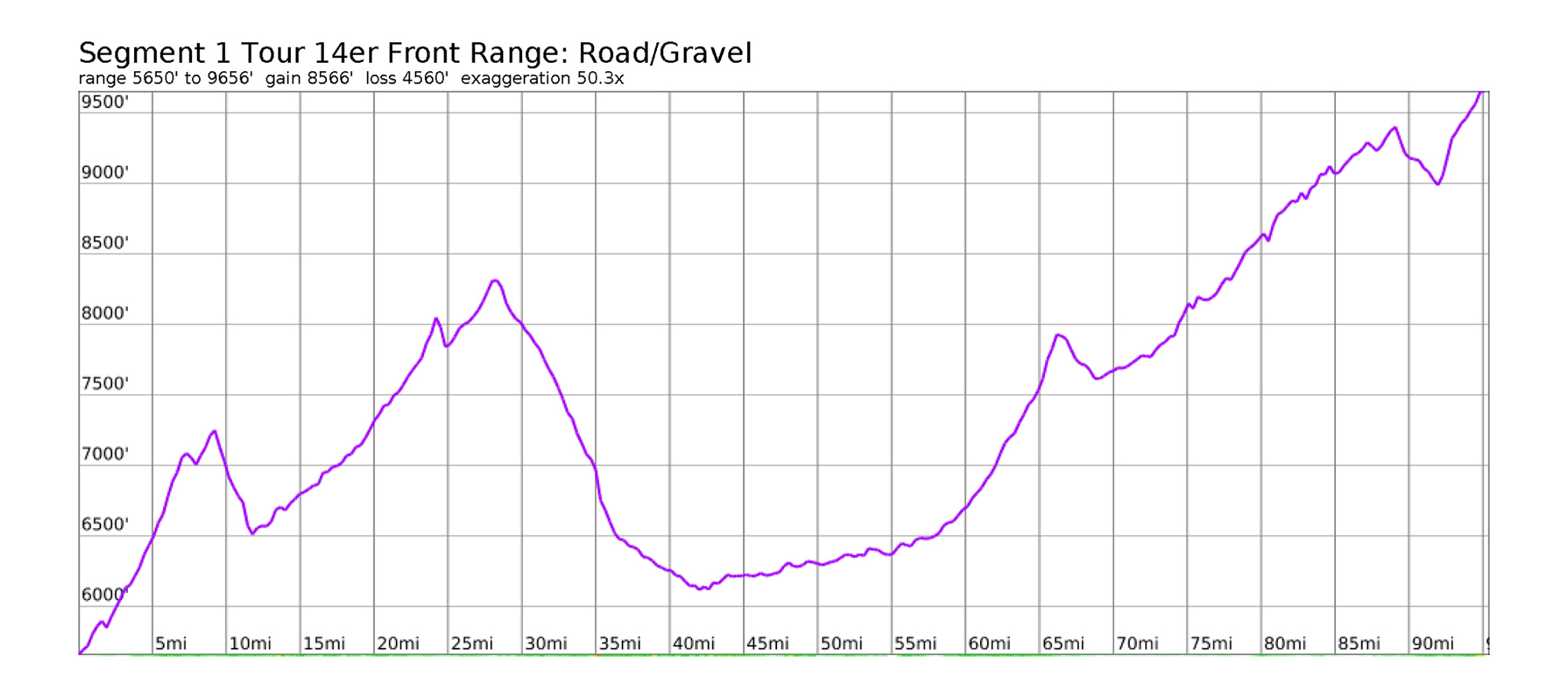
- Mileage: 96 miles
- Elevation Gain/Loss: 8,600’/4,600′
Our route starts at the American Mountaineering Center on 10th and Washington Ave. Head southeast for one block, and get onto the bike path that follows Clear Creek west. Transition onto the designated bike path that parallels 6th Ave, and take this bike path southeast until Heritage Road. Take a right on Heritage Road south. Heritage will fizzle out, but continue onto HW40/West Colfax south, and take this road until right before the I-70 underpass. Turn right onto HW40, say goodbye to the plains below and start climbing!
Continue on HW40 until the Paradise Hills Park and Ride. Turn left at the overpass here, cross over I-70, then turn left onto S. Grapevine Road, leaving the hustle and bustle of the interstate for good. Grapevine provides engaging road riding right in back of the foothills of Denver/Golden.
Reach the hamlet of Idledale and turn right onto Bear Creek Road and continue climbing up towards the town of Evergreen. Evergreen has a fair amount of services available to you, so you can start your trip somewhat light, to facilitate getting up those initial hills.
Evergreen Services
- Grocery: Safeway
3851 S, CO-74 - Coffee: Java Groove
28186 CO-74 #1 - Gear/Bike Shop: Outbound Mountain Gear
4600 Plettner Ln #1e
outboundmountaingear.com
Once in Evergreen, turn left onto CR 73 and take this south. Turn right of South Brook Forest Road to leave some of the busyness of CR 73 behind.
Turn left onto S. Blue Creek Road/CR 75 and take this road south until it’s end. Turn right back onto CR73 and continue on CR73 until the small town of Conifer. The grocery stores and other stores nearby are your last dependable resupply until Woodland Park. CR 73 will end. Jog momentarily onto HW285, then cross under HW285 and onto S Foxton Road.
Conifer Services
- Grocery: Safeway
27152 Main St - Grocery: Natural Grocers
27101 Main St
Enjoy your descent down S Foxton Road.
At a tight switchback, turn let onto W Platte River Road and take this road southwest. Going will be a bit rougher at the beginning, but enjoy the escape from traffic and congestion.
Water will be available to you at the South Platte River (definitely treat) . Easily access the South Platte where the Colorado Trail crosses over the Platte River Road. Share the gossip with the Colorado Trail thru hikers and bikepackers you may meet at this crossing point.
Transition to MTB Route
West Pine Creek Road will come out from the east, and junction at W Platte River Road. Take West Pine Creek Road east until it merges with HW 67, then take HW 67 northeast until Rampart Range Road. Rampart Range Road is well maintained gravel, although can get a bit roughed up from the 4WD traffic. It’s too good of a route to not mention getting on, rather than the all-pavement route narrated below. Rejoin the Road route narrative in Woodland Park.
Continue on Platte River Road, until it merges into HW 67, then take HW 67 south until the small trading post of Deckers. Deckers has a small cafe perfect for lunch, limited groceries, beer, and a place to get your fishing license!
Deckers Services
- Grocery/Restaurant: Deckers Corner
8570 CO-67
Sedalia, CO
https://deckerscorner.com
Once you’ve had your fill of ice cream floats and french fries, continue south on HW 67 until you reach Woodland Park. The initial climb up out of Deckers may leave you a bit winded, but the road riding here is excellent. The historical burn areas from the Hayman Fire leave this area looking almost alien.
Enter into Woodland Park, where the Road and MTB routes converge. Most all services will be available to you here, so stock up before camping for the night. Dispersed camping before Horsethief Park TH will be very limited. Fee camping at a NFS campsite is available, just north of town, or go full credit card touring, and get a cheap motel.
Continue on your way southwest on Highway 24. The highway, for the most part, has a very generous shoulder and a parallel bike path off the main highway. This bike path is almost unusable, so I would skip it if you enjoy your sanity.
Enter into the small town of Divide. A few services are available:
Divide Services
- Grocery: Teller Markets Grocery
11115 US-24 - Restaurant: McGinty’s Wood Oven Pub – Irish food. And pizza.
11115 US-24
Once filled with a slice or two (and a pint or two), carefully make your way onto Highway 67 south. We’ll be taking this all the way to Horsethief TH which will be on your left.
An alternative trail head will come up before Horsethief called, Crags. Crags is a very popular trail head for hiking Pikes. Access it by turning left onto Teller Country Road 62 and taking this to the Crags TH. Paid camping is available at the trailhead (first come, first serve). Take the Crags/Northwest Slopes route to the summit.
To reach Horsthief, continue on HW 67 until finding its small parking lot on the left. The Road and MTB route narratives will once again converge here. A dry camp can be made on the somewhat steep slopes on the first few switchbacks up the trail. It’s suggested to bring along your bike while bivying. Find a flat enough spot to get some rest for the hike the next day.
Hiking: Horsethief Park Trailhead to Pikes Peak
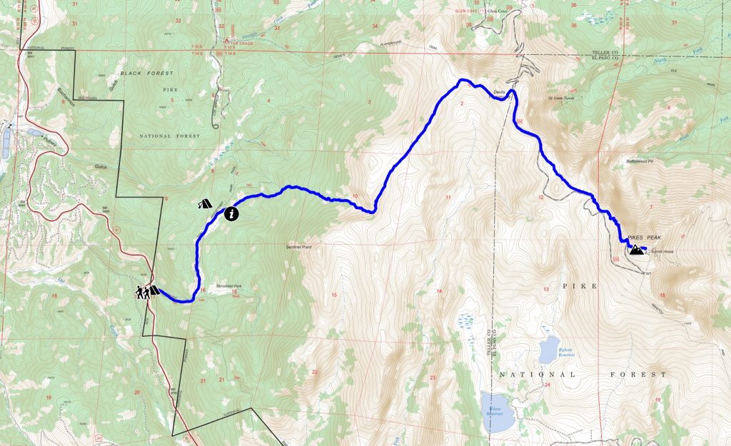
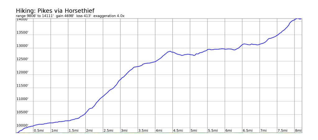
- Rating: Hard Class 2
- Mileage: 8.25 miles (one way)
- Elevation Gain/Loss: +4701’/-414′ (one way)
This is route isn’t used as much as the extremely popular Barr trail on the other side of the mountain, or the almost as popular Crags route just to the north. I believe it gives one a little more solitude and backcountry experience than either of these two routes.
From the trailhead, hike up the switchbacks of the Horsethief Park Trail. At the trail junction head left (north). Turn right at the next trail crossing. Turning left will take you to Crags, turning left will have you follow Oil Creek. This portion of the trail is smooth, wide and perhaps even rideable, if you don’t mind pushing a loaded down bike up some of the steeper grades – consider caching some gear at the start of your day.
The trail will fade at the start of a steep slope. If you’ve been adventurous this far, leave your bikes here. Find and follow cairns up a faint trail east. Turn northwards near a steep cliff. Oil Creek will turn into a waterfall and the faint trail and cairns will disappear.
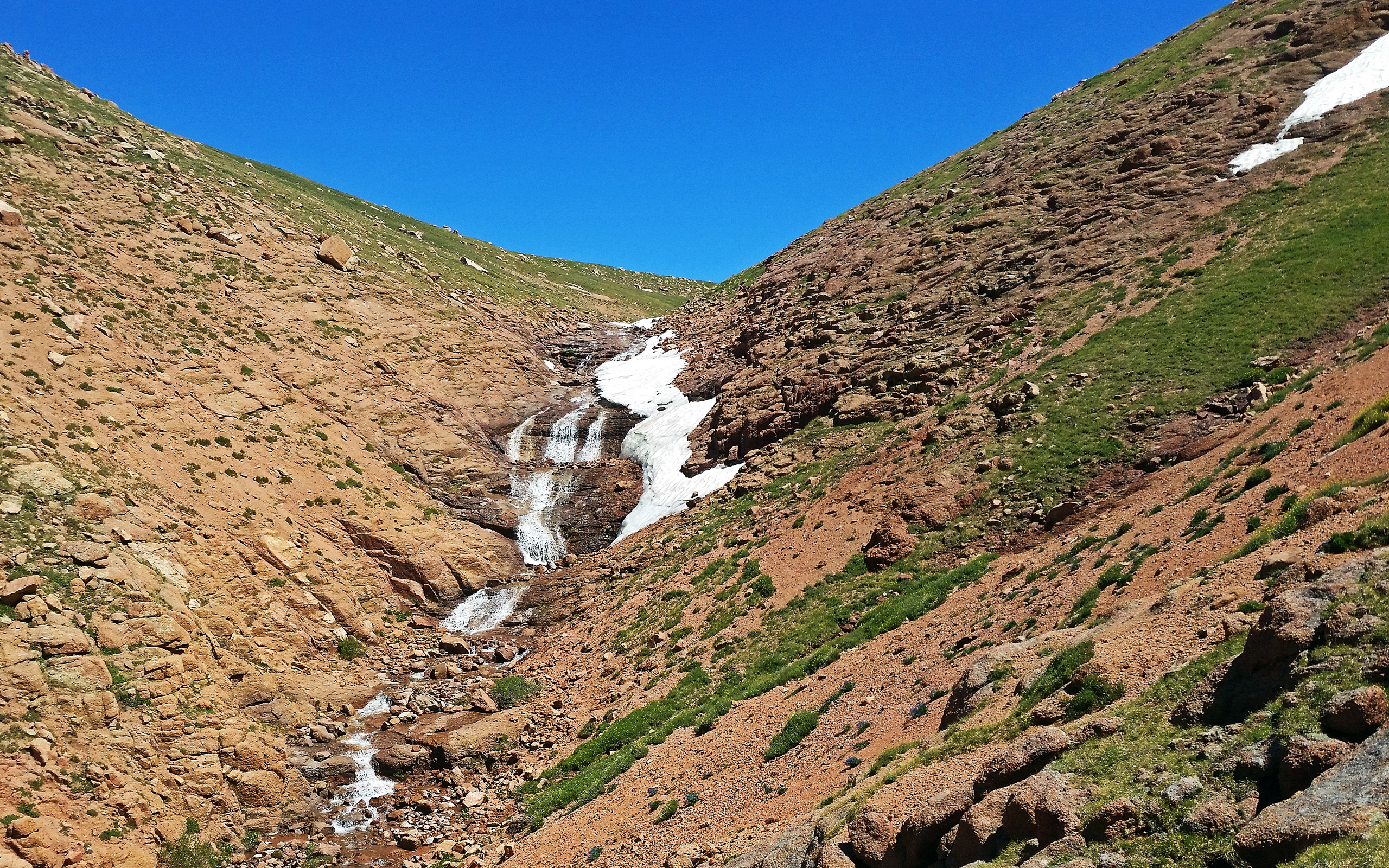
From here, hike cross country towards the Devils Playground, and join the Crags route, which will be on a very defined trail. The trail will take you to the Pikes Peak Highway, which you’ll have to carefully cross, then parallel for a little while on the east side. Follow the trail to the summit of Pikes Peak.
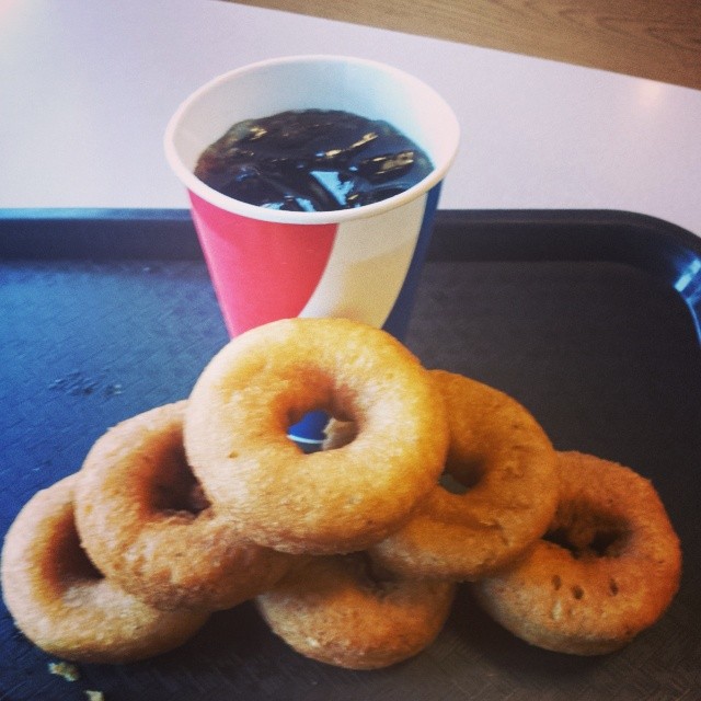
Somewhat unique to Colorado 14ers, a gift shop and cafe can be found at the summit, servicing hikers as well as those who merely drove to the summit/took the Cog Railway. The cafe is replete with donuts, and I encourage/dare you to eat as many as possible.
Double-back to descend the way you’ve came.
Highlighted Alternative: Pikes Peak Highway
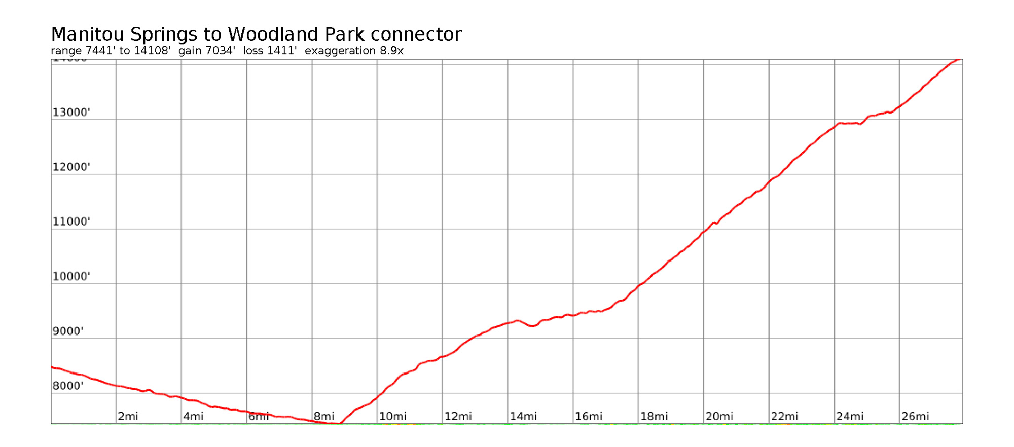
- Surface: Pavement
- Mileage: 28 miles (one way)
- Elevation Gain/Loss: +7037′ -1412′ (one way)
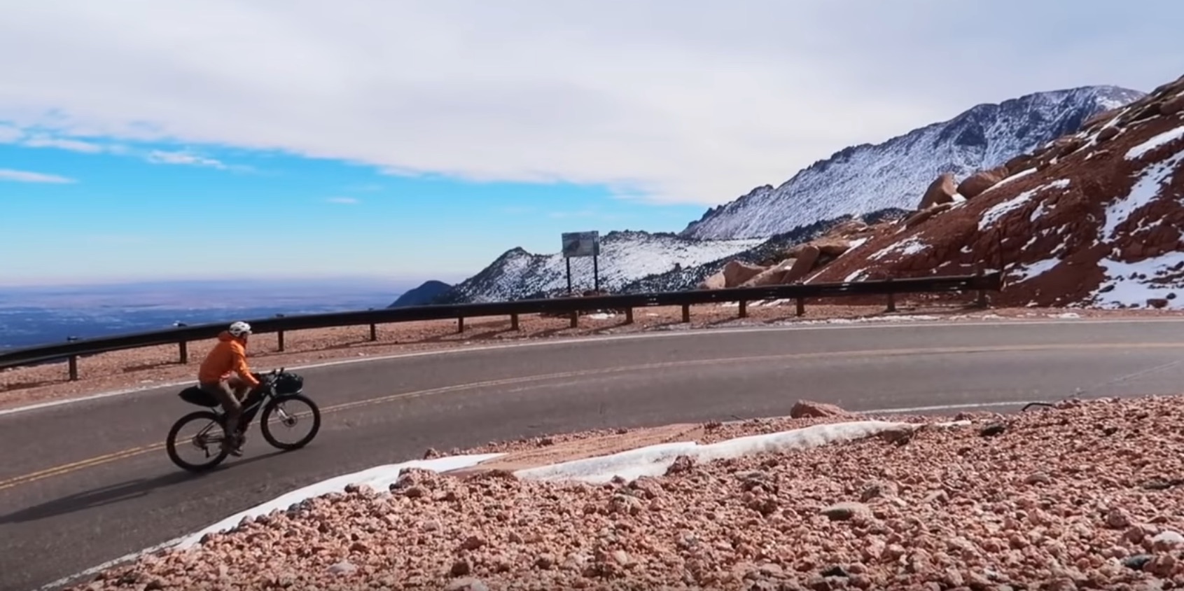
A bikepacking trip narrative to Pikes Peak wouldn’t be complete without at least suggesting cycling up to the summit of Pikes Peak itself, via the Pikes Peak Highway! It’s certainly one of the most awesome road hill climbs in the country. From Woodland Park head Southeast on the backroad route mapped out to the start of the Pikes Peak Highway. The highway entrance opens at 9:00am, and it’s suggested to start as early as possible to give yourself as much time as you need. Pay your fee and enjoy the ride.
- Pikes Peak Highway
pikespeakcolorado.com
(719) 385-7325
In Woodland Park, stock up on supplies, and get ready for the final leg of this segment. Take HW 24 south towards Divide. Turn left on Edlowe Road south. Edlowe Road will gain you access to the Ring the Peak trail system, a project to provide a trail system around Pikes Peak.
We’ll be taking this trail system from Edlow Road, to Crags Campground, then further to Horsethief. You’ll be accessing National Forest on this trail, and camping opportunities will present themselves. Horsethief Park Trailhead is at the end of this section of the route.
Dry camping is available near the trailhead itself, but better camping may be found a bit further up, before you reach the trailhead. If you do camp at the trailhead proper, you’ll need to backtrack a bit up the trail anyways when it comes to doing the hike up Pikes Peak itself.
Aprés Hike
Camping for the night can be done back at Horsethief, or if you have the legs, ride north on HW 67 (paved) to the town of Divide where food/groceries can be found. Once in Divide, one can ride north on CR 5 and find dispersed camping after the NFS boundary. The road is paved until the boundary, where it turns into gravel. If you have the legs, one can continue past Divide and Lake George and camp up on Tarryall Road.
Work in Progress
Bikepacking to the Colorado 14ers is currently being written and published publicly. Get news and updates by joining the Facebook group, Follow us on Instagram, join our subreddit, and mailing list.
You can support its development by purchasing items through the affiliate links on this site: check out the gear reviews, as well as the items below: