“Start anywhere.” – John Cage
The route you take is entirely up to you.
Below is a rough draft of an example of a route to cycle to and from the trail heads that serve the Colorado 14ers – routes from the TH’s to the summits are covered in great detail in other resources (see: Gerry Roach, Lou Dawson, 14ers.com).
The goal is to provide an off-road route (as much as possible and reasonable) for travel by bike, using known routes like the Colorado Trail and the Great Divide Mountain Bike Route, as well as well-known Passes like Cinnamon, Imogene, Pearl, Taylor and Argentine.
The goal of this route is not specifically one of speed, but of adventure, as well as removing the Challenger from as many busy, paved routes as possible (although, sometimes even that is unavoidable). An entirely different route could be created if one wanted to optimize for speed.
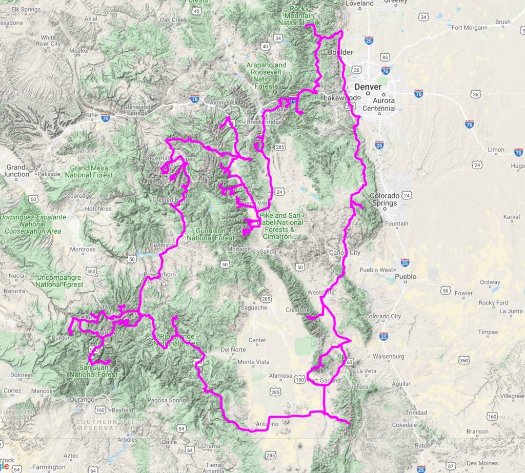
Update/Note: the embedded maps don’t seem to work anymore, and are outdated anyways. The narratives are still fine. The actual route taken can be seen in the following Caltopo Map (Both Tour14er and Tour of the Highest Hundred tracks are shown).
Golden, CO to Crags Campground (Pikes Peak)
Starting at the American Mountaineering Center in Golden, CO this route meanders through the last bastions of the suburban sprawl of the greater Denver/Golden Front Range Urban Corridor, towards the Northernmost terminus of the Colorado Trail, which itself can be taken all the way to Durango, CO (we’ll revisit it, later on – a few times).
It’s just a warm-up though, and our route leaves the CT on the dirt North Platte River Road. With a little jockeying to the East, you’ll then meet up to the start of Rampart Range Road (dirt), which will take you all the way to Woodland Park and HWY 24, where you’ll head slightly Southwest, to meet up with the Crags Campground TH, to start up Pikes Peak.
Cycling:
- Estimated length: 100 miles
- Estimated Time: ~ 12 hours
Summiting via Southwest Slopes/Crags:
An easy, albeit long hike.
- Estimates Length: 14 miles
- Estimated Time: 8 hours
Alternatives to this route is to just take Highway 67 South, forgoing much of the dirt.
Crags Campground to South Colony Road
Hey there, Cripple Creek Ferry. Taking the back side of Pikes out of the area, removes oneself from the Colorado Springs urban area, but still provides enough resupply points for the trek to the of South Colony Road, as well as a more direct, dirt route, shying away from pavement. A quick tour through the Shelf Road climbing area is a nice bonus. Peaks accessed from this trailhead:
- Crestone Needle
- Crestone Peak
- Kit Carson
- Challenger Point
- Humboldt Peak
As well as one of the four great 14er traverses: Crestone Needle -> Peak. This will be one of the most challenging sections of the entire Tour.
After Pikes, this should be a stout wake up call to the challenges that lay ahead.
Cycling:
- Estimated length: 95 miles
- Estimated Time: 12 hours
Summiting:
This is a big day, and no doubt weather will be the deciding factor in if this will go without any trouble. In the best conditions, this can be done as a huge traverse, counter-clockwise:
Humbolt -> Kit Carson -> Challenger -> Crestone Peak -> Crestone Needle
FKT is around 9h17min, which will be unattainable on tired legs. Figure half this speed; two full days will be allocated. If needed, two different trips could be done.
South Colony Lake TH to Lake Como TH
After a short resupply in Westcliff, it’s back to the grind, on an unimaginative route (with, perhaps a nice pass to liven things up) to take on another epic group of mountains:
- Little Bear
- Blanca
- Ellingwood
- Lindsey
As well as the second of the four great 14er Traverses: Little Bear -> Blanca
Cycling:
- Estimated length: 70 miles
- Estimated Time: 9 hours
Summiting:
This group of 14ers may also be coupled in a large traverse:
Little Bear – >Blanca -> Ellingwood -> Lindsey
Another huge day, rife with problems because of weather and tired legs. 2 days will be allocated.
Lake Como TH to Culebra TH
The last of the Sangres de Cristos, and the first full mountain range finished ends with a strange whimper, with the gentle slopes of pricey Culebra. Consider it a few days rest before the San Juans kick up. Depending on how fast the previous peaks take, you may actually have a few days rest before Culebra!
Cycling:
- Estimated length: 40 miles
- Estimated Time: 5 hours
Summiting:
- Estimated Length: 6 miles
- Estimated Time: 5 hours
Culebra TH to Creede via GDMBR
Whisking quickly across the San Luis Valley, one will reach the foothills of the San Juans close to the New Mexican border, outside of Conejos, CO. From there, one will meet up with the Great Divide Mountain Bike Route, askewing paved roads, and instead trading them for wide-open gravel grinding and a stout climb to wake you back up. We’ll divert off the GDMBR near Indiana Pass, and take a more direct route towards our next objective, sadly missing Del Norte. With only the small hamlet of Platoro (don’t drink the water) to hit before Creede, it should get your warmed up for the loneliness of the San Juans ahead. Creede will bring you to your first 14er: the gentle San Luis Peak.
Cycling:
- Estimated length: 160 miles
- Estimated Time: 20 hours
Tour des San Juans
An entire trip in of itself, the tour of the San Juan Mountains will have one travel in a clockwise direction, ticking off the San Juan 14ers as they come, while you travel through this intense region via mountain pass upon mountain pass:
After San Luis, there’s a resupply in Lake City, it’s then off to top Cinnamon Pass, to summit Redcloud/Sunshine and Handies via Silver Creek/Grizzly Gulch TH.
Another resupply in Silverton will get you ready for the Chicago Basin 14ers, further South (Sunlight, Eolus, North Eolus, Windom)
The Wilson Group becons next (Wilson Peak, Mt. Wilson, El Diente) and the third great 14er traverse encountered – El Diente -> Mt. Wilson.
A resupply in Telluride will set one up for Imogene Pass and the 14er it allows access to: Mt. Sneffels.
A quick stop in Ouray, up Engineer Pass to tag Uncompahgre and Wetterhorn. Aren’t you glad Lake City has that weird pizza parlor?
Cycling:
- Estimated length: 250 miles
- Estimated Time: 32 hours
Another difficult route to estimate, since this segment is cut by so many stops to climb and places to resupply.
Lake City, Gunnison, Crested Butte, The Elks, Taylor Pass to Leadville
The obvious choice to get out of Lake City is to take the paved road to Gunnison, and then to Crested Butte, where one will engage in historical-to-MTBers Pearl Pass, to reach Castle/Conundrum and Cathedral, a quick trip to Aspen (if they let you in the city limits, smelling like ya do), and to the rest of the Elks: Pyramid, Maroon/North Maroon (completing the great 14er traverses) and then off to Capital and Snowmass. Once the Elks are surmounted, it could feel like the light at the end of the tunnel will finally be faintly visible in the distance.
Hangerman Pass is the missing link between the Elks and the Sawatch and affords you to miss paved Independence Pass.
Cycling:
- Estimated length: 225 miles
- Estimated Time: actually, pretty hard to tell, as the cycling route will be left for each grouping of 14ers: Castle/Conundrum + Cathedral; Pyramid, Maroon + North Maroon; Capital + Snowmass
Summiting:
- Estimated Length:???
- Estimated Time: Give a full day for each of the three groups, so 3 full days, (some of that including cycling)
The Sawatch via the Colorado Trail
The Colorado Trail will be met again, this time for a more full engagement, The Sawatch have a bad rep. as talus slopes, but become delightful, when they’re talus slopes linked together with sweet, smooth singletrack! Mt. of the Holy Cross is the odd-mountain out of the group, and should probably be tackled first to get out of the way. Then, enjoy the tour south, picking off 14ers on your way: Massive, Elbert, La Plata, Huron, Missouri, Belford, Oxford, Harvard, Columbia, Yale, Princeton, Antero, Tabeguache and Shavano.
Utilize Leadville, Twin Lakes, Salida, and Buena Vista as useful resupply points as you see fit. Figure out the best way to link up multiple Sawatch 14ers in a day, or you could be here for weeks.
Cycling:
- Estimated length: 285 miles
Salida -> Breckenridge, Mosquitos/Tenmile
After a few burritos, it’s out the back door and onto the GDMBR, for a mellow dirt route back North to Hartsel , then Alma. Tag Sheridan, then Democrat, Lincoln, Cameron, Bross, and finally, Quandary to finish up the Mosquito/Tenmile range.
Cycling:
- Estimated length: 125 miles
Breckenridge -> Grays/Torreys, Evans/Bierstadt via Argentine Pass
Take the side roads out of Breckenridge and Summit County and up 13,000+ Argentine Pass and back down to the I-70 corridor, a little bit of a backtrack to tag Grays/Torreys, then back up Guanella Pass to hit up Evans/Bierstadt. Back down Guanella Pass to Idaho Springs and time to realize you’ve only got one peak left: Longs Peak.
Cycling:
- Estimated length: 90 miles
Idaho Springs to Longs Peak TH, and Finish!
Other than taking Oh My God Road outta Idaho Springs, it’s all pavement to the end. Summit Longs Peak with righteous aplomb and savour the (now) relatively easy cruise back to Golden, CO, any way you see fit as you chase the coming change in seasons.
Cycling:
- Estimated length: 125 miles