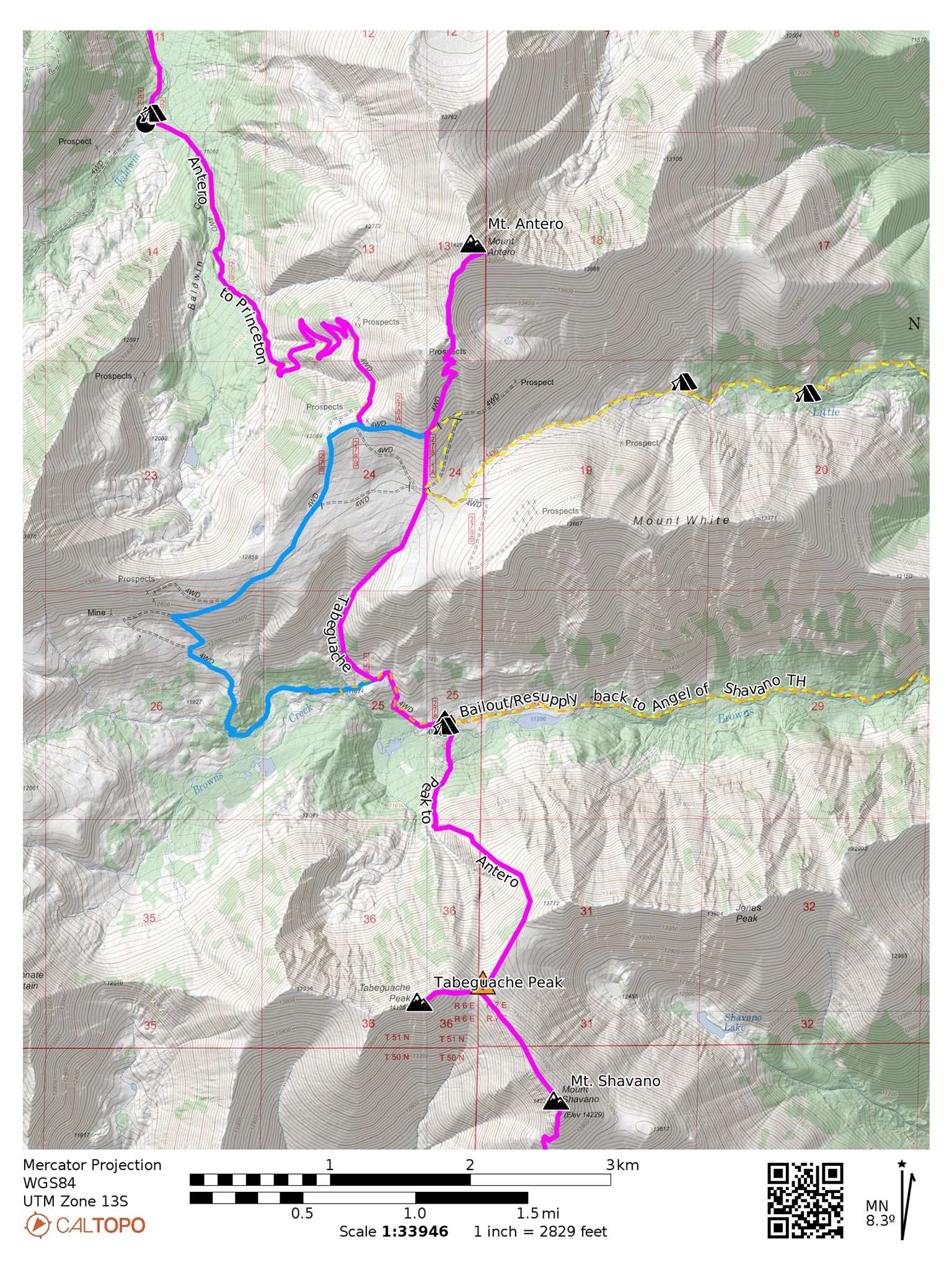
From Tabeguache Peak, we’re going to drop down all the way back below treeline into the Browns Creek Basin. The going is mostly off trail to Browns Creek, so be prepared for a lot of talus hopping. Footing is for the most part good, albeit steep. The route up to Antero is somewhat of a slog, and you’ll share your time with 4WD enthusiasts wondering why anyone would walk such terrain, so be ready to answer some questions!
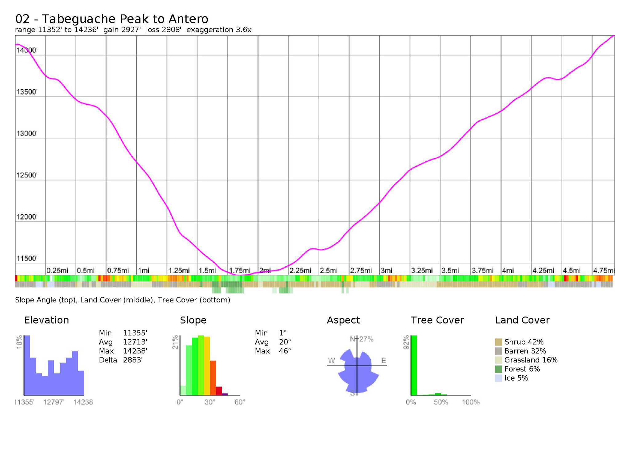
Nolan’s 14 Line Stats
- 4.94 Miles
- +2928‘
- –2810‘
Nolan’s 14 Line
From Tabeguache Peak, reverse your track until you reach the saddle of Tabeguache and Jones Peak West (38.62621,-106.24584). At this point you’ll be leaving the most popular route to Tabeguache Peak, and heading into more rough terrain.
Do a descending traverse on the northwest side of Jones Peak West, then descend to the east of a fairly deep and nasty looking gully. Don’t descend into the gully! You may be able to pick up an old, unmaintained trail once you reach tundra.
Pick your line off the slope and onto more gentler ground carefully, as the loosest material is on the bottom it seems. There are a few variations to this line, including hiking down the west side of the gully, but I’ve tried to describe one of the more reasonable lines.
Once at the bottom of the face of Jones West Peak, make your way north towards Browns Creek. Several old avalanche paths will lead you down, and a few cairns may make life easier.
Cross Browns Creek at an opportunistic place – it should just be a simple hop (38.64333,-106.24796), then follow the CR278 4WD northwest. Once you’re due south of a break of the south slopes of Mt. White, ascend off-trail into a gully on somewhat loose ground (38.64628,-106.25452) and follow this gully north toward Antero. Cairns/social trail may be present to help guide your way. Exit the gully on a barren plain between White and Antero (38.65487, -106.25217), and head north up Antero on a gentle ridgeline. You may be able to spot the 4WD road that we’re aiming for (38.66194,-106.25005).
Take this 4WD northeast towards the summit of Mt. Antero, and follow the road to an obvious parking lot. Prepare yourself for a lot of Jeep traffic – there isn’t much of a wilderness experience in this part of the line. Once at the Jeep parking lot, spy a social trail that will take you on the last bit of elevation to the summit of Mt. Antero (38.66803,-106.24791).
Slowlans Alternative
The going down Tabeguache is steep and loose, no matter how you do it. There’s no reasonable alternative to get into the Brown’s Creek Drainage or points north, other than reversing your route all the way back to Shavano, then down the trail to the Colorado Trail. Descending into Shavano Lake is the precursor of many search and rescue calls.
To summit Antero, stay on the 4WD track after crossing Browns Creek and head west instead of hiking off trail (38.64626, -106.25449). This road will switchback up the slope to the west of the Nolan’s 14 line and bring you up to another 4WD track that will then take you up almost to the summit of Mt. Antero/Jeep parking lot and allow you to rejoin the main line. From there take the social trail the last few hundred feet to the summit of Mt. Antero.
Water
- Copious and reliable water can be found at Browns Creek (38.64345,-106.24849).
Camping
- Good dispersed camping can be found around Browns Creek (38.64345,-106.24849) – pick a nice spot near the creek, and under the trees. Don’t expect to be alone in this location though, as it is possible to take a 4WD vehicle close into this area.
Bailing/Resupply
Once you cross over Browns Creek, head east on the 4WD track you come upon, and take this track east (38.64368, -106.24801). The 4WD track will end, and the Browns Creek Trail will begin. Take this trail east until it runs into the Colorado Trail (38.66193, -106.17973). From here, you have two choices. You can hike north to Chalk Creek/Mount Princeton Hot Springs for a quick dip, dinner, or ice cream at the store (38.73330,-106.16445).
Or head south back to your starting point at the Shavano Trailhead (38.59674,-106.19674), making a round trip. Plentiful camping is available along the Colorado Trail.
Skipping
Once you cross over Browns Creek, head east on the 4WD track you come upon (38.64368, -106.24801), and take this track east. The 4WD track will end, and the Browns Creek Trail will begin. Take this trail east until it runs into the Colorado Trail (38.66193,-106.17973). Once at the Colorado Trail, hike north to CR 162 (38.71734,-106.19925).
From here, you have two choices. Head west towards the townsite of Alpine on CR 162 (you probably want to hitch a ride) to rejoin the main Nolan’s 14 line to Mt. Princeton (38.70976,-106.28897). Head east to continue on the Colorado Trail to take the Slowlans alternative for Mt. Princeton – or even to skip Mt. Princeton altogether and continue on towards Mt. Yale.