Get ready for a roller coaster of a ride! The descent down Mt. Yale is one of the wildest parts of the route and you may swear off bushwhacking for the rest of your life! Take a small breather and get ready to summit Mt. Columbia, followed closely but Mt. Harvard. The traverse between the two has been the setting of many a meltdown, but keep your cool to start your graduation out of the Collegiates.
Nolan’s 14 Line Stats
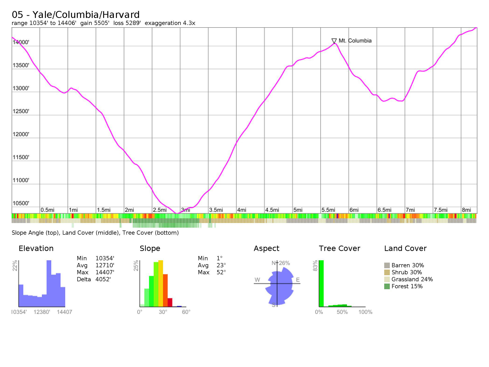
- 8.29 miles
- +5507′
- -5291‘
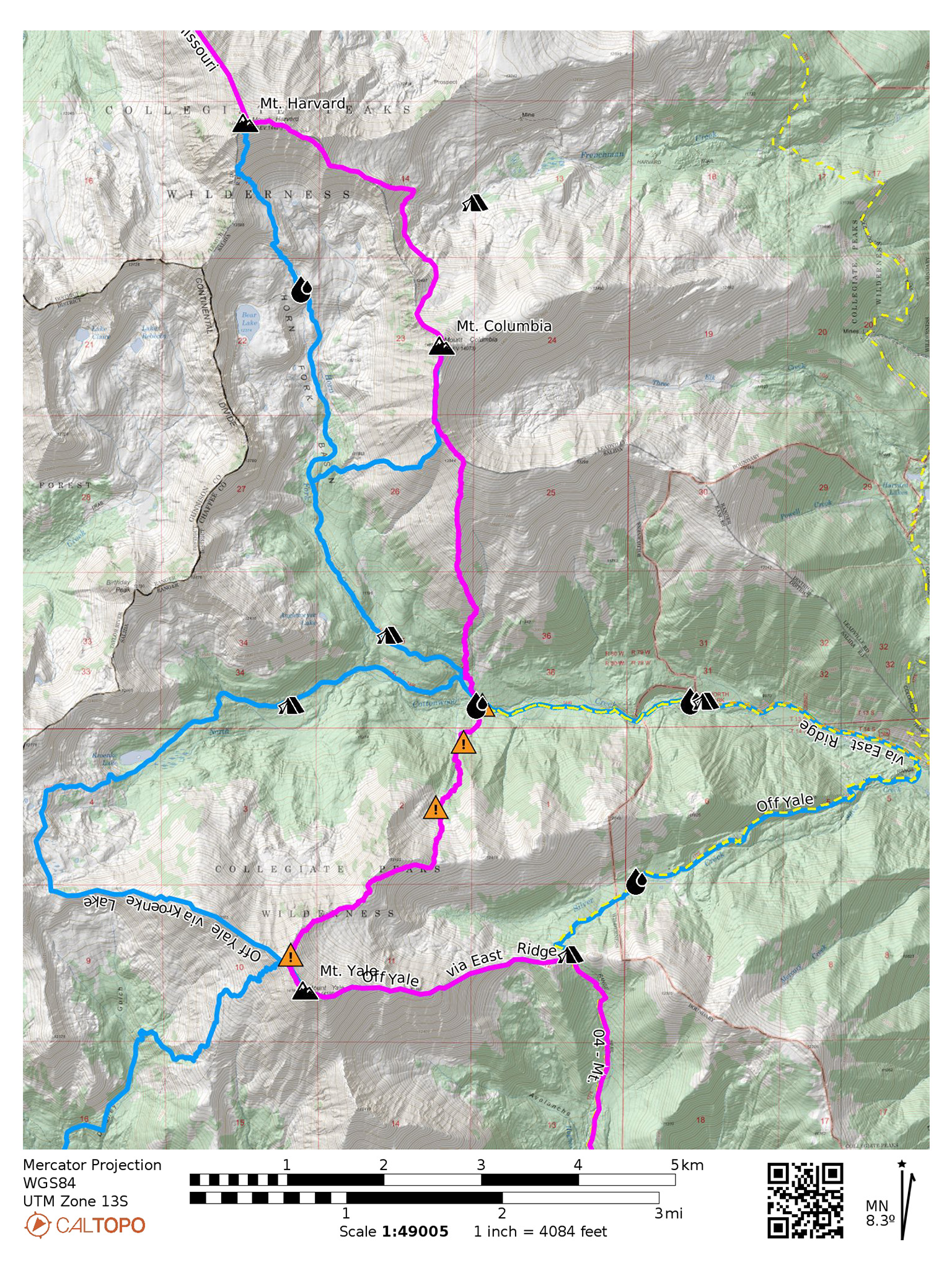
Nolan’s 14 Line
From the summit of Yale, hike west, then northwest initially following Yale’s standard Southwest Slopes route. Break from it fairly soon and descend off of Yale’s northeast ridge. At this point, you can easily hike right on the ridgeline, but at a saddle between Yale and Point 13105, it’s much more efficient to side hill it on the southeast face, traversing east and down to a much broader saddle between Point 13105 and Point 12619.
From this saddle, descend north towards Cottonwood Creek. The going starts as easy talus hopping at a reasonable grade. Pass by the scattered wreckage of a crashed plane from 1956. The going becomes much more steep, once you dip below treeline and into the avalanche chute. This gully is filled with young green trees – a sign of much Winter and Spring avalanche activity. The steepness of the chute is hard to imagine – this could be some of the steepest hiking you’ll experience on the entire route!
Soon the grade will ease up again, only to present you with the next challenge: some fairly stout bushwhacking. The middle of the gully features overgrown shrubbery. To the east you may find older-growth forest, complete with a mess of downed trees. Some game trails may be useful in this area. Look for bountiful stashes of raspberries as well! The east side of the gully may prove an easier exit, especially when cross the creek.
Your last, and final challenge before reaching an honest to goodness trail is crossing Cottonwood Creek. Pick your crossing point carefully – a large downed tree or two may provide access by tip-toeing across their trunks. Don’t go for a swim.
Attain the trail, which splits just a few paces to the west. The southern/left fork will take you to Kroenke Lake. Take the northern, right fork that goes to Horn Fork Basin.
Once you’re on the trail up into Horn Fork Basin, take it for only a minute and turn north at a small unnamed creek that crosses the trail and set off up the loose, steep slope, bushwhacking north up Mt. Columbia (38.87332,-106.29453). Stay to the west of this creek and east of any large cliffs you may encounter. The creek will retreat into a deep gully that you’ll want to stay well away of. The slope will soon turn into more of a broad ridge. Find your way onto the crest of the ridge itself, meet up with the standard route, and take it all the way to its summit.
From Mount Columbia, follow its northwest ridge down until you reach a small saddle, then drop from the ridgeline to the northeast side of the main ridgeline that connects Columbia with Harvard. The main ridgeline can also theoretically be taken on, but the brief splitter hand crack crux goes at an exciting 5.7. Ascend Harvard’s southeast ridge and follow it northwest to the summit of Mount Harvard. This traverse isn’t the most pleasant – prepare for a lot of loose side hilling and talus hopping (14ers.com route description).
Slowlans Alternative
Descending Yale
The Nolan’s 14 line off of Mt. Yale is as “classic” as it gets for this style of bushwhackin-eering. It’s also the most direct line down to Cottonwood Creek by a considerable margin. Many alternatives exist if you’re not feeling the very exposed ridgeline, steep avalanche chute, mess of downed trees, creek crossing, or other character building challenges.
Yale’s East Ridge
From the summit of Mount Yale, descend Yale’s East Ridge Route (Class 2) to the Colorado Trail. Take the Colorado Trail north to the Silver Creek TH. Follow CR 365 West to the North Cottonwood Creek Trailhead and rejoin the Nolan’s 14 line at the Kroenke Lake/Horn Fork Basin trail junction (38.87082,-106.29284).
Kroenke Lake Route
From the summit of Mount Yale, descend Yale’s Northwest Ridge, towards Peak 12,995. Head north before ascending Peak 12,995. Some Class 3 terrain will be found here. You’ll locate the Kroenke Lake trail west of the lake itself. Follow the trail northeast, then east until you reach the Kroenke Lake/Horn Fork Basin trail junction and rejoin the Nolan’s 14 line. Camping in the Kroenke Lake area would be a highlight of this alternative.
Ascending Mount Columbia
From the Kroenke Lake/Horn Fork Basin trail junction, continue onto the Horn Fork Basin Trail, past where you would break off from the trail to ascend Columbia via the standard West Slopes route (14ers.com route description). The trail up this peak used to be devastatingly terrible, but trail work is being done to create a new, sustainable trail. Most of the trail is built but the last third still seems in turmoil. Active work on then trail may be encountered. If you plan to camp before summiting Columbia, this is a great alternative to take, and is just as fast if not faster than the Nolan’s 14 line with the new trail work.
Mount Columbia to Mount Harvard
From Mount Columbia, descend the West Slopes route (14ers.com route description) back to the Horn Fork Basin trail. Continue on the trail north, and take Harvard’s standard route (14ers.com route description) up to its summit.
Water
- Water is scarce from the summit of Mount Yale until you get to North Cottonwood Creek. On the main line, the steep avalanche gully may hold a small seasonal creek (38.86330,-106.29648).
- Cottonwood Creek makes a fine water source, but do make especially sure to treat the water, it’s a high-use area, including guided horseback groups (38.87060,-106.29330).
- If taking the Mount Columbia alt. and/or the Mount Columbia alt, plenty of running water is available, until you start ascending the west slopes in earnest.
- The next water source after Harvard will be Pine Creek (38.94664,-106.33623)
Camping
- Good dispersed camping near water sources is available in both the Horn Fork Basin (38.89138,-106.31335), as well as along the Kroenke Lake Trail (38.87060,-106.31533). It’s suggested to camp just below treeline.
- Once you ascend any of the slopes/ridges, camping (as well as water sources) will dry up. There’s little option on the standard Columbia to make a rough camp around 12,200′ (38.91706,-106.29353).
- Your next option to camp after Harvard will be at Pine Creek (38.95476,-106.31434).
Bailing/Resupply
Reach CR 365 from the main Nolan’s 14 line by hiking east on North Cottonwood Creek trail, all the way to the N. Cottonwood Creek TH (38.87070,-106.26671). Buena Vista is easily reached from CR 365, and chances of catching a hitch into town are great.
Skipping
Reach CR 365 from the main Nolan’s 14 line by hiking east on North Cottonwood Creek trail to the N. Cottonwood Creek TH (38.87070,-106.26671). Continue east on the dirt road, until the Colorado Trail (38.86449,-106.23863) and take the Colorado Trail north until the Pine Creek Trail (38.96483,-106.27670). Take the Pine Creek Trail west until you’re south of Mt. Oxford (38.94765,-106.33573).
Next: Mt. Harvard to Mt. Oxford/Mt. Belford, and Missouri Mountain