Like this? Follow me:
My time in Salida on tour soon came to an end, after a little time at the hostel with an honest to goodness shower. Time for me to travel north! Out of Salida, there’s some pretty awful highway riding to get directly to the next town, Buena Vista, and the day I set off saw me face a stiff headwind, that only got worse as I got closer and as a storm cell was moving from west to east. Frustrating!
I made it to Buena Vista, which I was going to only use as a top-off spot for food, etc – but my Brother was in town for Paddlefest, so I decided to linger a bit. After another partial day of rest, the weather turned much nicer, and I continued my ride to Chaffee County 390. The road out of BV North is dirt, and follows an old railroad line complete with tunneled out sections of the hillside, making things quite fun. TONS of people were out for Paddlefest – or just the good weather – I’ve honestly never seen it so packed.
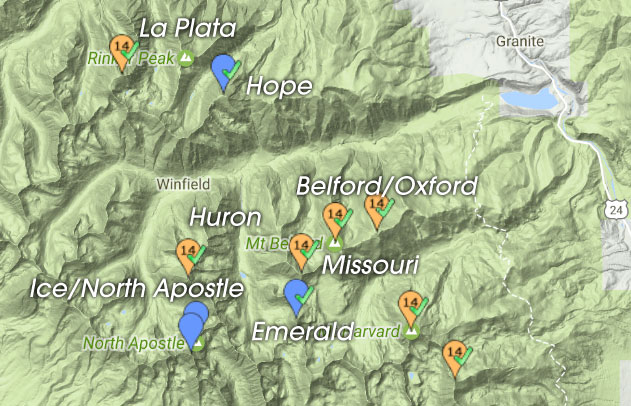
A little more highway riding, then Clear Creek Reservoir shows itself, which signals the turnoff left for 390. A fairly special road – the bike-version of the Colorado Trail dumps you off of 390 after taking you up and over a saddle from Twin Lakes; there’s a very well known old mining ghost town called Winfield which is used as the halfway point for the Leadville 100; and most importantly for me, it’s a Mother Lode of Centennials! –
I may target up to nine separate peaks that I could summit from this one access road in only a couple of days. From West to East:
- La Plata
- North Apostle
- Ice
- Huron
- Hope
- Missouri
- Emerald
- Belford
- Oxford
There’s judicious opportunity for mass-linkups – on my Tour 14er, I was able to basically link up all the 14ers from this road in a single day: Huron/La Plata/Missouri/Belford/Oxford – one of my strongest days! Tour of the Highest Hundred will be a little different – as 9 is a lot to do in just one day – or even two, but these high numbers of peaks, and flexibility in the order in which I take these all on, lend themselves well to doing a good speed run on them. Three days would be awesome:
- Day 1: N. Apostle/Ice/Huron
- Day 2: La Plata/Hope
- Day 3: Missouri/Emerald/Belford/Oxford
As far as Centennials (that aren’t 14ers), I’ve only done Hope in this group, so N. Apostle/Ice, as well as Emerald were my two focus points. I decided to check out N. Apostle/Ice first, as they have somewhat of a reputation.
I set up camp a little past the start of the 4WD track that 390 turns into after Winfield. The track became fairly snow covered, and the sun was setting, so it seemed like a good place. For the early morning alpine start, I started setting up basically all the gear I brought: snowshoes for the approach, ice axe/crampons for the climb up to the saddle of Ice/North Apostle, tons of clothes, food – whatever else I could fit into my Fastpack 35. Ugh!
In the morning, I set out for Ice, a little nervous. Following the track I had pre-programmed seemed to be taking a ton of time, and the creek crossing down and up a steep ravine seemed ridiculous. Surely, this can’t be the way? At the other side of the creek, I entered post-hole hell, as the forest kept its stash of snow greedily – instead of an easy grade up to the lower basin of ice, it was as if a frozen sea of ocean rollers were there to greet me. Even though I brought snowshoes, I was too stubborn to stop and actually put them on, so every now and then, I’d just fall hip deep into a hole of my own making. Gugh!
Reaching the lower basin, I was very much in awe over the setting. The lower, and upper basin of ice were completely covered in snow, and I felt as if I was transported somewhere much more serious than the happy-go-lucky Chaffee County 390. I must say, I was a little nervous. I finally stopped, and put on my snowshoes, and started the approach to the upper basin.
It wasn’t long until I reached an area too steep for snowshoes, so I stashed them (thank Gawd), and continued in microspikes to the upper basin. the upper basin somewhat demanded crampons, so I did another song-and-dance to get those on, get the ice axe out – I hate these gear changes (bring up summer!). The upper basin was completely white, completely silent, and all this just continued to make me nervous. The snow climb up to the saddle of Ice/North Apostle – both of which were my objectives today, isn’t super steep, but it’s not chill either.
I began noticing other signs that were giving me pause: each and every aspect in the upper basin showed signs of recent avalanche activity – including the very slope up to the saddle. I pressed on, but with a bit of trepidation. Snow conditions felt off – the snow wasn’t the crunchy Styrofoam I was hoping for, but was rather layered, with a thick crust, over essentially sugar. Under that, who knows? I didn’t think of digging a pit, but the closer I got to the saddle, the more I realized that this snow wasn’t going to get better. I could climb to the top, but would descending make sense? There’s no real other way to descend.
I had to make a decision, and I decided to bail. It’s was already after 9:00am – had I been at this exact spot at 6:00am, I may have pushed on, but this seemed silly. I was already seeing how bad the snow was – I was walking in avalanche debris! As much as it hurt my fragile little ego, I turned around, plunged step’d down the way I came. Each step went already above my ankle, or to the top of my knee, or all the way to my hip. Yikes.
Beaten down by an immovable, and unfeeling force of nature, I trudged back with all my heavy gear, happy to be in such a beautiful place, but still, a little lost on what else to do on this day. I decided to stash some gear at the Huron trailhead, and do a quick(er) dash up to the summit. Avalanche conditions – even late in the day, shouldn’t be too bad. In fact, they were night and day – Huron feeling like a friendly place in comparison to the hallowed ground of the Three Apostles – the thought of continuing up the route I wanted to recon still giving me chills.
Huron’s summit was easily topped, and I began the post-hole/ski-glissade (if I was lucky!) trip back down to camp. Back at camp, I sat by the creek and filled myself with food. Huron was a nice consolation. Tomorrow, I decided to go a lot lighter – no snow shoes/ice axe/crampons/helmet or 35 liter pack – just my Fastpack 15 liter almost running vest pack, trekking poles and microspikes. Missouri should be no big deal, and I’ll be down in no time.
I honestly don’t know what I was thinking. I found Missouri and the Missouri Gulch chock-full of snow – the North Chutes of Missouri completely filled in. I lost the trail to Missouri before I even got to the junction and just took a face on the north side to what I hope was a ridgeline that would take me to Missouri’s main north ridge. Easy, right?
Easy, I guess, but slow-going. I did finally get to the main north ridge. I found conditions a bit spicy – enough that having the security of an ice axe – or even crampons, would have been a blessing. But of course, those were left at camp. I decided to continue. Weather looked good, and I had plenty of time in the day. The snow was heating up insanely fast, though, so I tried not to dawdle.
Though of course, a few hundred meters from the summit, the route turns a bit serious, and I found myself doing somewhat sketchy snow traverses just below the ridge itself. Finding this situation unappealing, I made the decision to just take the ridgeline. This may have been a mistake. The rock quality of this ridge is poor, and > 100lb rocks were already perfectly set up to topple on top of me if I were foolish enough to use them as, say: a handhold. I kept it together, but seriously reconsidered the idea of retracing my steps to descend, whatever that looked like. I was following a lone pair of steps – they must of had the same idea, as I saw their descent went down a couloir I’ve only descended in the summertime. That ended in avalanche debris – whoa! Hope everything is OK – I didn’t hear of an accident! So, that idea, is out!
Finally summiting Missouri, I… kind of realized I didn’t bring a ton of food with me. Not completely alarming, but something I noted. Hmm, how to get down? Ridgeline was out, couloir was out. Ah! Elkhead Pass! Elkhead Pass cuts between Missouri and Belford/Oxford going north to south. I could continue on the ridgeline I was on, which ducks down and gets way more casual. Following the ridgeline would allow me to tag an unranked 13er, Iowa, and then a Centennial, Emerald! Brilliant! From there, I could descend the Emerald/Iowa saddle, simply walk to Elkhead Pass, take that back into the right side of the basin, and hike back to the bike!
Iowa/Emerald were summited quickly and easily. But, from the vantage point of the summit of Emerald, it was quite clear that Elkhead Pass wasn’t passable: The entire ridge of Elkhead Pass was snowed in, and in parts: was topped with a meaty cornice. Well, shit.
Options for self-extraction were getting a bit thin: I could retrace going over Iowa AND Missouri, take the sketchy ridgeline that’s now poised to slide, I could walk out to the highway from this basin – a good 15 miles of snow covered trail, or, I could look and see if there was another way of getting on the ridge of Elkhead. “Shit!”, I thought, “I may have to summit Oxford, today!”.
I spied, and I cringed when I did, a subsidiary ridge line that bee-lined to Missouri’s East Ridge – once on this ridge, I could gain access to the northern Missouri Gulch basin, and get outta here.
I knew this, because I’ve taken Missouri’s East Ridge – it’s a memorable ridgeline and goes at Class 4. But, it’s also way loose and scary. Now we get to add snow to the mix: great. But, it was the only realistic option. So I pressed on.
The ridge started as a steep pile of gravel (great), the type that slides you back almost as far down as you’ve stepped up. To my relief – and after surviving this, it became a steep, Class 3 ridge. Loose, but, doable. I only needed to climb a few hundred feet to gain the ridgeline itself, and from there, it was a ridge walk a little bit more east to get to easier ground.
But of course, I became impatient. It seemed that it would be doable to traverse over more east and meet to the ridgeline as it started dipping down. I knew enough about the east ridge of Missouri that the going – even on the top of the ridge, wasn’t going to be breezy, so I wanted to engross myself as little as possible with it. To my perspective, there was a few ledges I could hop across to do exactly what I wanted to do.
Except those ridges were spaced out, and in between were some fairly steep faces of snow. I’m sweating through everything I own at the moment, and the chance of causing a wet slide – however small, was getting kind of great. A small slide wouldn’t harm me, but would bring me down a few hundred meters to the bottom – and of course, the bottom cliffed out. There’s nothing really to do but to keep it together, do the traverses over the way-scary snow quickly and efficiently, and thank your maker later. Long story short, I’m typing this, so the plan worked, but I can’t suggest it for others.
I walked the ridge to a low point, and ski-glissaded the much mellower north side to the basin below. Success! Just another post-hole death march back to camp.
It’s funny for me to compare my two days. The first day, I felt over-conservative (looking back) of my decision of not going for N. Apostle/Ice. On the second day, I threw caution to the wind for Missouri/Iowa/Emerald. I never felt, I guess, “afraid”, but I had put myself into a dicey situation, then got myself out – and perfectly fine with that, too. I guess I assessed the risk and mentally one day was a , “no”, the other was a, “yes”
I returned back to camp, and ate most of the rest of the food I packed, except for two granola bars. I broke camp, and made the ride to Leadville.
Goodbye, Chaffee County, 390! I shall return.
