Like this? Follow me:
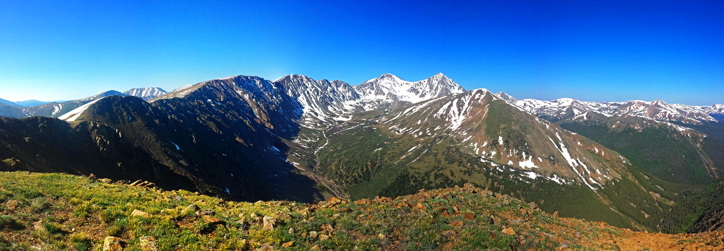

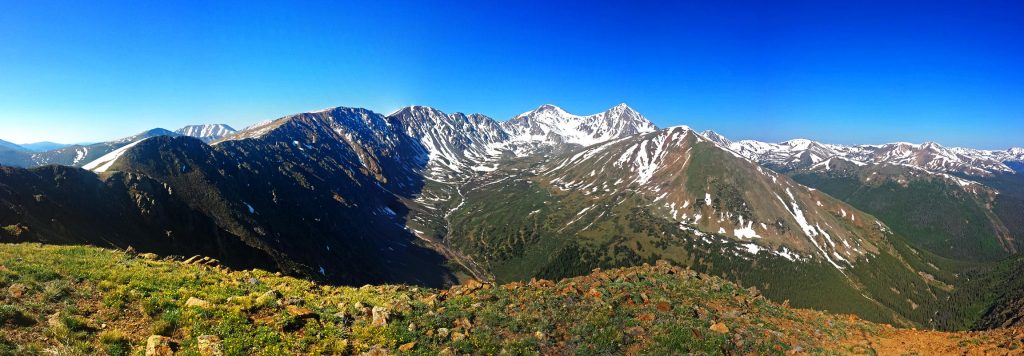
The Front Range 14ers Grays and Torreys make an excellent beginner 14er hike – it was one of the first 14ers I ever did. Being so close to the Front Range Urban Corridor – less than an hour from Denver, it still affords some dramatic changes in environment, not the least because of the sweeping ridgeline going West to East to Northeast from Grays Peak, and ending essentially at I-70. When hiking up (or driving, I guess) up the beginning of Stevens Gulch, you can’t but feel that the world is closing in on you, and you’re now entering a different place altogether.
You may also, like me, have the urge to be on top of this ridge line. Not many obvious entrance points present themselves from the start of the Summer trail head to Grays Peak, to the summit of Grays Peak itself. The ridge is rocky and broken, with much rockfall danger. You could, and people have, find a weakness in the ridge to climb up, but I don’t suggest it. In this route, I outline what is sure to be a classic traverse over the entire Steven’s Gulch; bagging you two 14ers, a Class 3 ridge scramble, and at least 2 13ers – one of which (Mt. Edwards) is a Centennial. If that’s not enough, you’ll also go over a mountain that used to be labeled a 14er, McClellan Mountain – actually height: 13,587′ which faked out turn-of-the-century tourists!; as well as many smaller 12ers, in your hike to close out the loop.
Some stats of the route as I describe it:
- 14.5 miles
- 7,000 feet elevation gain/loss
- mostly off-trail, w/Class 3 scrambling
- no easy bailout point after Grays Peak
- crampons/ice axe recommended until late in the summer season
This route is not to be underestimated, it’s a requirement to get an alpine start, and to not be afraid to bail, if weather comes in (bailout points are noted, below). Be strong in your logistics game.
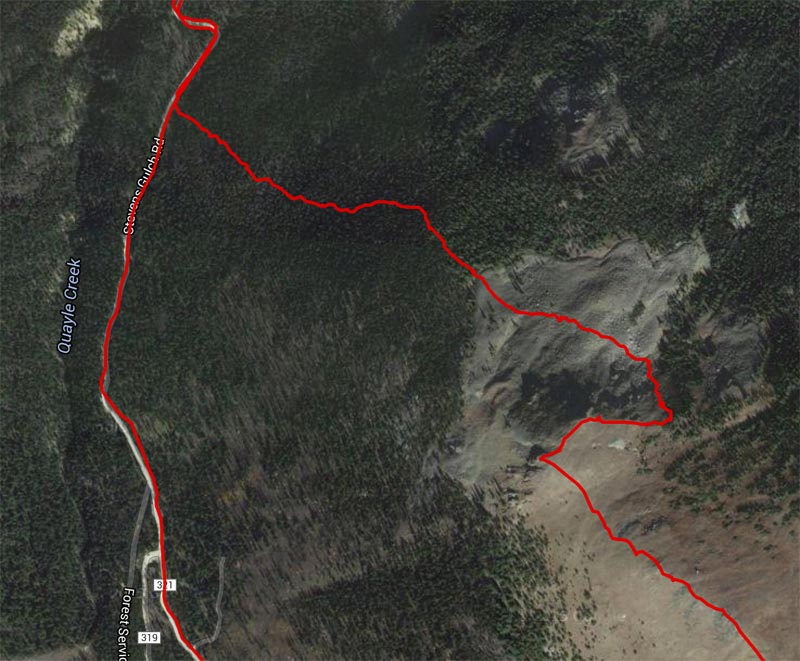
The start of this route I describe begins basically at the Winter trail head of Grays Peak (not the Summer trail head, farther up the road). Plan to start very early for this route. My suggestion would be to summit Kelso Mountain – around 4.5 miles into the tour, at sun up. I started myself around 2:30 am.
Because of the early start, you may want to camp near the trail head. I don’t suggest camping in the Winter trail head parking – that may not be legal. But rather, you could camp higher up the road. The road itself is a public right of way through some private land, so please respect the private land, as well as not parking in any way that would block this busy road for others to use.
When I did this route, I made my approach by bike, and camped a little west of the Winter trail head off of the bike path – which itself doubles as part of the Continental Trail. This is again a little less than ideal, as Interstate I-70 is just a few hundred feet away, and large tracker trailers will be checking their speeds with very loud braking mechanisms.
Perhaps the best or at least easiest choice for camping is to camp at the summer trail head, where there is ample free, legal, and quiet(er) camping available. This area is very popular to camp in, so don’t expect to be alone – it still will beat camping by the highway. This will also cut the first three miles or so of dirt road hiking – just remember you will still have to do this, to finish your loop!
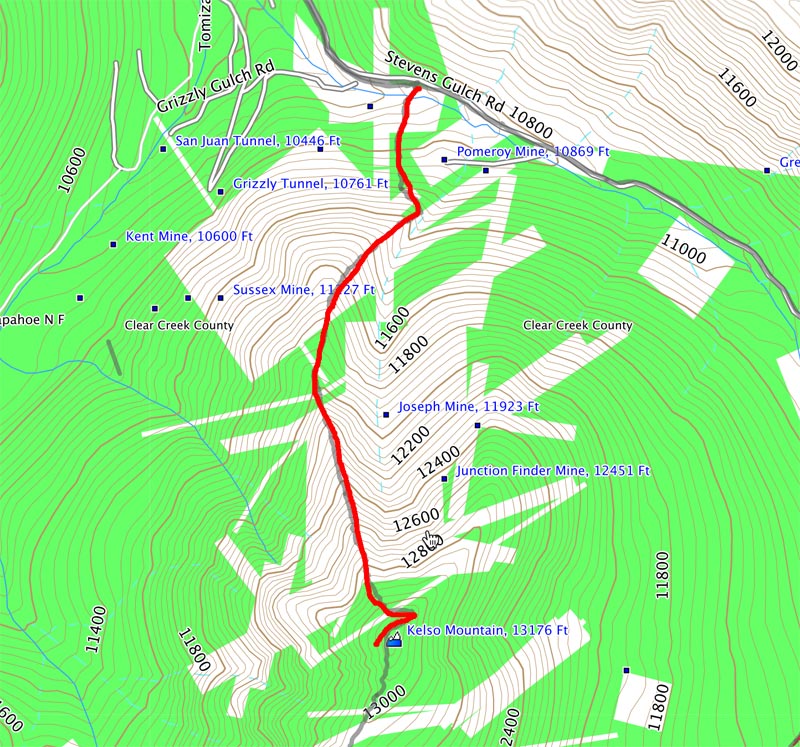
Starting from the Winter trail head, follow the road the summer trailhead (3 miles), continue on the Grays Peak trail for another .9 miles until you’re at the south east face Kelso Mountain. Leave the trail and go… straight up Keslo Mountain! This is an avalanche-prone area, so only attempt this route when avalanche threat is low or nonexistent. It’s about .5 miles to the summit at a pretty stiff grade. Once on Kelso (and if the sun is already up!), indulge yourself with the rest of the route the lies before you, in almost a 360 degree view.
- Bailout Point: head straight down the way you came.
Next stop is Torreys Peak. Find Kelso’s south ridge and descend the Class 3 terrain to the saddle between Kelso Mountain and Torreys. If the terrain becomes difficult, head to climbers left, but ultimately, try to stay on the ridge as close as possible. I do not suggest spending too much time on the right (North) side of the ridge.
- Bailout point: the saddle between Kelso and Torreys has a trail that will lead you to the main Grays Peak trail. Take it, then turn left on the main trail to go back to the summer trailhead.
Once at the saddle, it’s time to take on Kelso Ridge, which is a classic Class 3 ridge scramble in of itself. Depending on the conditions, bringing along crampons and an ice axe may be useful – especially at the last pitch, as a snow field usually guards the summit. Enjoy this ridge, as you will ultimately lose much of your solitude for a while, once you summit Torreys.
Once you summit Torreys, congratulate yourself, you are at mile #6.5, when measured from the Winter trail head. Most, but not all, of the scrambling is over, and your hike to Grays should be a relatively easy one.
- Bailout Point: head to the saddle of Torreys and Grays, and take the Grays Peak trail back to the summer trail head.
Follow the obvious trail and perhaps throngs of people to Grays Peak, the second 14er of the day, the high point of this tour, the highest point on the Continental Divide Trail, and highest point of the Continental Divide in North America.
- Bailout Point: Take the Grays Peak trail back to the summer trail head. This is the last bailout point on this route that will take you easily back to the summer trail head. You will options to bail from this route, but only into the wrong drainage!
From Grays Peak, follow the ridgeline east towards Mt. Edwards and The Remarkables – a series of bumps along the ridge. Summiting these are optional, but I would suggest that you do. You may find some social trail segments on your way to Mt. Edwards, but don’t count on it. You should be able to keep things Class 2+. Once on Mt. Edwards, keep following the ridgeline as it slowly curves North. The way should be obvious until the very end of the ridgeline.
- Bailout Points: all the bail out points will have you drop to the right of the ridgeline, and into a separate basin near the Waldorf mine. There is a 4wd road that reaches almost to the summit of McClellan Mountain, but following it will bring you back to Guanella Pass and almost to Georgetown – this is the wrong basin from which you started. Attempting to descend back into Stevens Gulch is a fairly dicey proposition, given the loose nature of the rock.
Once you’ve exhausted the ridgeline, it’s time to go down. Several options present themselves, but I decided on jogging east slightly at a flat area, low on the ridgeline, then descending Northwest on steep terrain, following a line of trees. This is most likely the crux of the route, especially since it’s being done on tired legs.
The terrain is mostly steep tundra and talus, but the angle of the slope will exceed 40 degrees . When you’re descending, look for the giant boulder field below and aim for it. This boulder field will continue past treeline, and allow the easiest entrance to your bushwhack back to the road.
Continue heading NW, picking up game trails along the way. Take your time to find the best line, and always remember the road to the Summer trail head will be to your left (west), so don’t wander too much to your right (east).
Reach the road (hurray!) then back to your starting point: if it’s the Winter Trailhead, it’s just a short hike down the road; Summer Trailhead, time to do one last climb.
Route Variations:
Ascent: Another way up Kelso mountain, is to start up nearer to the Winter Trailhead and take the ridgeline that follows the avalanche gulley. I don’t suggest this, as you would essentially have to cross over someone’s backyard, into private property, over a creek, then ascend a very steep line into thick trees, to get to the gravely ridgeline:
There may be a better way to descend the ridgeline to the west of where I descended, but I didn’t see anything exceptionally promising. Whatever you do, do not descend any of the ridge between Grays and the Summer trail head, except the Edwardian Couloir and probably only then in good snow conditions.

Just read through this for the first time. My friend Logan (I think you may kinda at least know the dude) did this with absolutely nothing, luckily there were some snowballs left up there to munch on! We definitely waded across the creek and were likely in private property, but given that its also clearly an avalanche chute, I’m reluctant to care about being there since any and all above ground property will be destroyed every year. Despite legal ramifications it did seem a bit more environmentally responsible to take this more rocky and forested route as opposed to walking on tundra up from the standard trail. I really liked the descent from Kelso Mtn to the Kelso-Torreys Saddle, very fun rock hopping with intermittent tundra to keep things stable. We also definitely descended a gully too early to connect to essentially the other side of the avy chute on Kelso. I remember it seeming very lose and annoying but I’m not sure I’d think it was *that* bad after some of the other crap I went on later last summer! Certainly by no means preferable though. We parked halfway up the road, so we were trying not to have to do extraneous climbing on the road. I’ll have to try parking lower and traversing the final ridge all the way to the end for the full experience, this route is definitely the way to go on these peaks, we thought the view from Edwards/McClellan was the best vantage possible of G&T which otherwise often look non-exciting.